Making of Canada, the North - Published 1997 by National Geographic
Historical Regional Map | Yukon, Northwest Territories & Nunavut | Wall Format (683 × 520 mm) | Premium Finishes
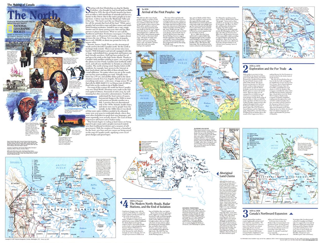
A powerful exploration of Canada’s vast northern frontier, The North reveals a landscape defined by scale, resilience, and cultural depth. Published by National Geographic in September 1997 as part of the Making of Canada series, this map brings together geography, Indigenous history, and modern political change.
From Arctic tundra to remote settlements, it presents a compelling view of northern Canada—highlighting the enduring presence of First Peoples and the historic formation of Nunavut.
Why This Map Stands Out
A true northern perspective
Explores one of the most remote and expansive regions in the world.
Part of the Making of Canada series
Combines storytelling with precise cartography.
Strong cultural focus
Highlights the history and presence of Indigenous peoples.
Historic political context
Captures the emergence of Nunavut as a new territory.
A meaningful wall map
Ideal for both education and display.
🗺️ What the Map Shows
- Northern Canada, including:
- Yukon
- Northwest Territories
- The formation and extent of Nunavut
- Arctic landscapes including tundra, waterways, and ice-covered regions
- Remote communities and regional connections
- Historical context of the region’s first inhabitants
- Geographic framework linking environment, culture, and governance
📐 Size & Format
683 mm (W) × 520 mm (H)
Landscape orientation
A practical format ideal for:
- Classrooms and geography education
- Home offices and studies
- Libraries and cultural displays
- Interiors inspired by Arctic and remote landscapes
✨ Premium Finishes
| Format | Description |
|---|---|
| 📜 Paper (160 gsm) | Heavyweight matte-coated paper—ideal for framing. Preserves clarity and fine detail. |
| 🧼 Laminated (Encapsulated) | Sealed in 2 × 80-micron gloss laminate. Durable, wipe-clean, and suitable for reference use. |
| 🪵 Laminated + Timber Hang Rails | Laminated map mounted with lacquered natural timber rails and hanging cord—ready to display. |
| 🖼️ Canvas (395 gsm HP Professional Matte) | Printed with archival pigment inks. Adds depth and a refined finish. |
| 🪵 Canvas + Timber Hang Rails | Canvas paired with timber rails for a gallery-style presentation. |
🔨 Please allow up to 10 working days for professionally mounted hang-railed finishes.
📊 Specifications
| Feature | Detail |
|---|---|
| Title | Making of Canada: The North |
| Publisher | National Geographic |
| Published | 1997 |
| Dimensions | 683 mm × 520 mm |
| Orientation | Landscape |
| Map Type | Historical / Regional |
| Coverage | Northern Canada (Yukon, Northwest Territories, Nunavut) |
| Collections | Canada, Historical |
| Materials | 160 gsm matte paper / 2 × 80-micron laminate / 395 gsm HP Professional Matte Canvas |
| Printing | Pigment-based, fade-resistant inks |
| Origin | Printed in Australia |
🎯 Ideal For
- Students and educators of Canadian geography and Indigenous history
- Those interested in Arctic regions and northern development
- Collectors of National Geographic historical maps
- Interiors seeking a unique, remote landscape display piece
- Gift buyers looking for a thoughtful and educational map
❄️ A Land of Scale and Heritage
Canada’s North is defined by:
- Vast, sparsely populated landscapes
- Deep cultural roots of Indigenous peoples
- Harsh yet beautiful Arctic environments
- Political and geographic change shaping modern identity
This map captures that essence—offering a clear and compelling view of a region where land, culture, and history converge at the edge of the Arctic.
🤝 Our Commitment
- Printed in Australia using archival-quality production
- Faithfully reproduced to preserve clarity and detail
- Premium materials selected for durability and longevity
- Each map is hand-checked before dispatch
- Carefully packaged for safe delivery
🚚 Delivery
- Paper, Laminated, Canvas (rolled): Dispatch within 1–2 business days
- Hang-Railed Maps: Made to order—allow up to 10 working days
- Packaging: Securely rolled in protective tubing
Explore Canada’s northern frontier—
a map that brings the Arctic, its people, and its story into focus.
👉 Order now and add a powerful northern perspective to your wall.
Original: $57.20
-65%$57.20
$20.02Product Information
Product Information
Shipping & Returns
Shipping & Returns
Description
Historical Regional Map | Yukon, Northwest Territories & Nunavut | Wall Format (683 × 520 mm) | Premium Finishes
A powerful exploration of Canada’s vast northern frontier, The North reveals a landscape defined by scale, resilience, and cultural depth. Published by National Geographic in September 1997 as part of the Making of Canada series, this map brings together geography, Indigenous history, and modern political change.
From Arctic tundra to remote settlements, it presents a compelling view of northern Canada—highlighting the enduring presence of First Peoples and the historic formation of Nunavut.
Why This Map Stands Out
A true northern perspective
Explores one of the most remote and expansive regions in the world.
Part of the Making of Canada series
Combines storytelling with precise cartography.
Strong cultural focus
Highlights the history and presence of Indigenous peoples.
Historic political context
Captures the emergence of Nunavut as a new territory.
A meaningful wall map
Ideal for both education and display.
🗺️ What the Map Shows
- Northern Canada, including:
- Yukon
- Northwest Territories
- The formation and extent of Nunavut
- Arctic landscapes including tundra, waterways, and ice-covered regions
- Remote communities and regional connections
- Historical context of the region’s first inhabitants
- Geographic framework linking environment, culture, and governance
📐 Size & Format
683 mm (W) × 520 mm (H)
Landscape orientation
A practical format ideal for:
- Classrooms and geography education
- Home offices and studies
- Libraries and cultural displays
- Interiors inspired by Arctic and remote landscapes
✨ Premium Finishes
| Format | Description |
|---|---|
| 📜 Paper (160 gsm) | Heavyweight matte-coated paper—ideal for framing. Preserves clarity and fine detail. |
| 🧼 Laminated (Encapsulated) | Sealed in 2 × 80-micron gloss laminate. Durable, wipe-clean, and suitable for reference use. |
| 🪵 Laminated + Timber Hang Rails | Laminated map mounted with lacquered natural timber rails and hanging cord—ready to display. |
| 🖼️ Canvas (395 gsm HP Professional Matte) | Printed with archival pigment inks. Adds depth and a refined finish. |
| 🪵 Canvas + Timber Hang Rails | Canvas paired with timber rails for a gallery-style presentation. |
🔨 Please allow up to 10 working days for professionally mounted hang-railed finishes.
📊 Specifications
| Feature | Detail |
|---|---|
| Title | Making of Canada: The North |
| Publisher | National Geographic |
| Published | 1997 |
| Dimensions | 683 mm × 520 mm |
| Orientation | Landscape |
| Map Type | Historical / Regional |
| Coverage | Northern Canada (Yukon, Northwest Territories, Nunavut) |
| Collections | Canada, Historical |
| Materials | 160 gsm matte paper / 2 × 80-micron laminate / 395 gsm HP Professional Matte Canvas |
| Printing | Pigment-based, fade-resistant inks |
| Origin | Printed in Australia |
🎯 Ideal For
- Students and educators of Canadian geography and Indigenous history
- Those interested in Arctic regions and northern development
- Collectors of National Geographic historical maps
- Interiors seeking a unique, remote landscape display piece
- Gift buyers looking for a thoughtful and educational map
❄️ A Land of Scale and Heritage
Canada’s North is defined by:
- Vast, sparsely populated landscapes
- Deep cultural roots of Indigenous peoples
- Harsh yet beautiful Arctic environments
- Political and geographic change shaping modern identity
This map captures that essence—offering a clear and compelling view of a region where land, culture, and history converge at the edge of the Arctic.
🤝 Our Commitment
- Printed in Australia using archival-quality production
- Faithfully reproduced to preserve clarity and detail
- Premium materials selected for durability and longevity
- Each map is hand-checked before dispatch
- Carefully packaged for safe delivery
🚚 Delivery
- Paper, Laminated, Canvas (rolled): Dispatch within 1–2 business days
- Hang-Railed Maps: Made to order—allow up to 10 working days
- Packaging: Securely rolled in protective tubing
Explore Canada’s northern frontier—
a map that brings the Arctic, its people, and its story into focus.
👉 Order now and add a powerful northern perspective to your wall.


