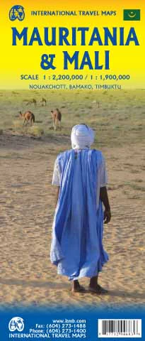
Mali ITMB Map
🇲🇱 Mali Travel Map – ITMB
Updated Edition | Optional Laminated Finish | Folded or Flat
Size: 690 mm × 990 mm
Publisher: International Travel Maps (ITMB)
🗺️ Discover Mali with Confidence and Detail
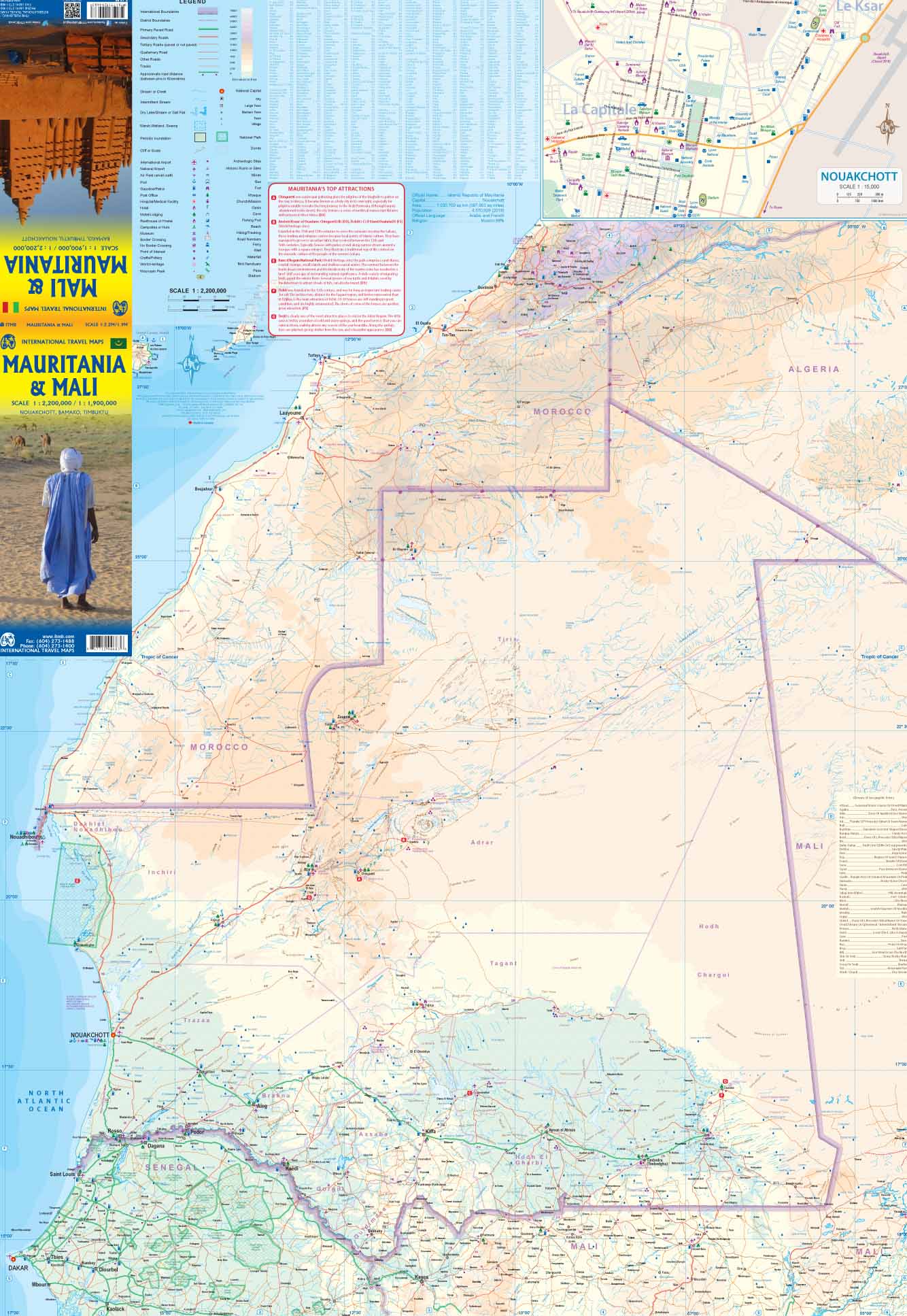
This updated ITMB map of Mali offers a clear and practical overview of one of West Africa’s most culturally rich and geographically diverse nations. Designed for travellers, researchers, educators, and planners alike, it places special emphasis on key tourist destinations, transport routes, and regional highlights.
Mali has a relatively strong road network for the region, and this map outlines major highways, secondary roads, towns, and national borders, alongside key rivers and desert zones such as the Niger River Valley and the edges of the Sahara.
🌍 Map Features
-
✅ Up-to-date road network, with clear symbols for paved and unpaved routes
-
✅ Highlights tourist attractions, cities, borders, rivers, and terrain shading
-
✅ Covers the full country, including Bamako, Timbuktu, Gao, Segou, and Mopti
-
✅ Ideal for anyone planning travel, study, aid work, or cultural exploration in the region
-
✅ Printed on high-quality stock for durability and clarity
🛡️ Optional Laminated Finish – For Durability
Upgrade to a laminated version to make your map long-lasting and interactive:
-
💧 Encapsulated in 80-micron gloss laminate – waterproof, tear-resistant, and stain-proof
-
🖍️ Write-on/wipe-off surface – perfect for annotating routes or marking locations with whiteboard markers
-
📍 Apply and remove map dots or stickers without damage
-
⚠️ Note: Laminated maps are produced by flattening folded stock; minor fold lines may still be visible
📐 Specifications
| Feature | Details |
|---|---|
| Map Title | Mali Travel Map |
| Publisher | ITMB – International Travel Maps |
| Format | Folded (standard) or laminated (flat) |
| Material | Paper or 80-micron gloss laminate |
| Size | 690 mm × 990 mm |
| Edition | Updated with enhanced tourist data |
👤 Who Is This Map For?
-
🌍 Travellers and tour operators heading to West Africa
-
📚 Researchers and educators studying Sahelian geography or African development
-
🧭 NGOs and humanitarian workers operating in remote areas
-
🗺️ Collectors or map lovers interested in high-quality international cartography
🛒 Add the Mali ITMB Map to your travel kit or research library and explore one of West Africa’s most compelling landscapes with confidence and clarity
Original: $17.85
-65%$17.85
$6.25Product Information
Product Information
Shipping & Returns
Shipping & Returns
Description
🇲🇱 Mali Travel Map – ITMB
Updated Edition | Optional Laminated Finish | Folded or Flat
Size: 690 mm × 990 mm
Publisher: International Travel Maps (ITMB)
🗺️ Discover Mali with Confidence and Detail
This updated ITMB map of Mali offers a clear and practical overview of one of West Africa’s most culturally rich and geographically diverse nations. Designed for travellers, researchers, educators, and planners alike, it places special emphasis on key tourist destinations, transport routes, and regional highlights.
Mali has a relatively strong road network for the region, and this map outlines major highways, secondary roads, towns, and national borders, alongside key rivers and desert zones such as the Niger River Valley and the edges of the Sahara.
🌍 Map Features
-
✅ Up-to-date road network, with clear symbols for paved and unpaved routes
-
✅ Highlights tourist attractions, cities, borders, rivers, and terrain shading
-
✅ Covers the full country, including Bamako, Timbuktu, Gao, Segou, and Mopti
-
✅ Ideal for anyone planning travel, study, aid work, or cultural exploration in the region
-
✅ Printed on high-quality stock for durability and clarity
🛡️ Optional Laminated Finish – For Durability
Upgrade to a laminated version to make your map long-lasting and interactive:
-
💧 Encapsulated in 80-micron gloss laminate – waterproof, tear-resistant, and stain-proof
-
🖍️ Write-on/wipe-off surface – perfect for annotating routes or marking locations with whiteboard markers
-
📍 Apply and remove map dots or stickers without damage
-
⚠️ Note: Laminated maps are produced by flattening folded stock; minor fold lines may still be visible
📐 Specifications
| Feature | Details |
|---|---|
| Map Title | Mali Travel Map |
| Publisher | ITMB – International Travel Maps |
| Format | Folded (standard) or laminated (flat) |
| Material | Paper or 80-micron gloss laminate |
| Size | 690 mm × 990 mm |
| Edition | Updated with enhanced tourist data |
👤 Who Is This Map For?
-
🌍 Travellers and tour operators heading to West Africa
-
📚 Researchers and educators studying Sahelian geography or African development
-
🧭 NGOs and humanitarian workers operating in remote areas
-
🗺️ Collectors or map lovers interested in high-quality international cartography
🛒 Add the Mali ITMB Map to your travel kit or research library and explore one of West Africa’s most compelling landscapes with confidence and clarity