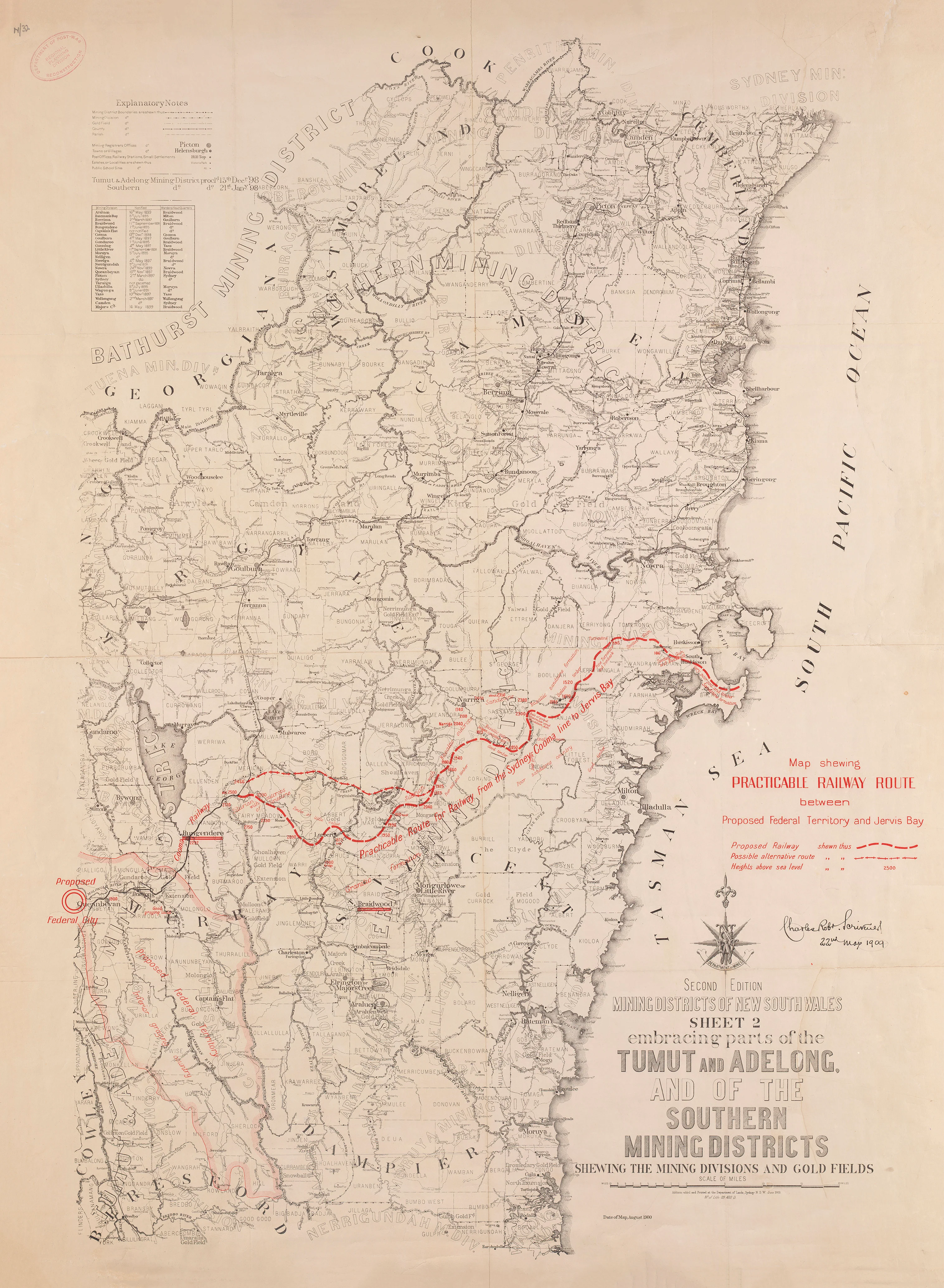
Map Shewing a Practicable Railway Route between the Proposed Federal Territory and Jervis Bay (1909)
Map Shewing a Practicable Railway Route between the Proposed Federal Territory and Jervis Bay (1909)
Map Shewing a Practicable Railway Route between the Proposed Federal Territory and Jervis Bay (1909)
The strategic rail vision behind Australia’s national capital
This important Commonwealth-era government map was prepared in 1909 to support the decision-making that led to the establishment of Canberra as Australia’s federal capital. Compiled by Charles Robert Scrivener—the surveyor whose recommendations ultimately shaped the choice of the Yass–Canberra site—and printed by the New South Wales Department of Lands, this map sets out the most practicable railway route linking the proposed Federal Territory to the coast at Jervis Bay.
Created for presentation to the Parliament of Australia, the map visualises the essential logistical problem of the new capital: secure access to a seaport. Proposed railway alignments are shown prominently in red, laid over a detailed base map of mining districts, parishes, tracks, and terrain—revealing how geography, industry, and infrastructure intersected in the birth of the nation’s capital.
This is not just a railway plan.
It is a foundational document in Australia’s federal story.
🧭 What This Map Shows
-
Proposed railway routes from the Federal Capital site to Jervis Bay (highlighted in red)
-
The Yass–Canberra region and surrounding districts
-
Mining districts, parishes, and localities
-
Existing tracks and transport corridors
-
Relief shown by hachures and spot heights
-
Base mapping derived from Mining Districts of New South Wales, Sheet 2 (1900)
🚆 Why This Map Matters
-
Prepared by Charles Robert Scrivener, architect of the Canberra site selection
-
Produced specifically for Commonwealth Parliamentary deliberation
-
Demonstrates early thinking around rail access and a national port
-
A rare survival from the Federal Capital proposed sites map series
-
Combines infrastructure planning, topography, and political history
Few maps so clearly show Australia thinking itself into existence.
🗂️ Historical Context
This sheet formed part of a seven-map folio published to accompany Scrivener’s 1909 report to the Minister of Home Affairs, addressing railway access, water supply, and port connectivity for the proposed capital. The highlighted rail corridor to Jervis Bay reflects long-held strategic concerns about defence, trade, and independence from state capitals—ideas that shaped Canberra’s early planning even when the railway itself was never fully realised as envisioned.
✨ Premium Print & Display Options
Printed in Australia using archival methods to preserve colour, linework, and historical integrity.
| Finish | Description |
|---|---|
| 📄 Heavyweight Paper (160 gsm matte) | Archival matte surface with excellent colour fidelity; ideal for framing under glass. |
| 🔒 Laminated (True Encapsulation) | Sealed between 2 × 80-micron gloss laminate; durable, wipe-clean, and tear-resistant. |
| 🎨 Archival Canvas (395 gsm HP Professional Matte) | Pigment-based, fade-resistant inks with gallery-grade presence. |
| 🪵 Laminated + Timber Hang Rails | Natural lacquered timber rails, ready to hang (allow up to 10 working days). |
| 🪵 Canvas + Timber Hang Rails | Elegant, frameless wall presentation (allow up to 10 working days). |
📐 Size (W × H)
730 mm × 1000 mm
Orientation: Portrait
Aspect ratio: ~1 : 1.37
Framing tips:
-
Allow a 2–3 mm mat overlap for traditional framing.
-
For modern displays, a float-mount with a ~3 mm reveal highlights the red railway alignments beautifully.
Custom sizing: Available on request.
🎯 Ideal For
-
Canberra and Federation-era history enthusiasts
-
Railway and infrastructure historians
-
Libraries, museums, and educational institutions
-
Government offices and planning environments
-
Collectors of rare Australian government maps
🤝 Our Commitment
Printed locally in Australia with archival pigment inks, careful colour management, and hand-checked finishing—packed securely and ready to display.
Choose your finish and own a key planning map from the birth of Australia’s national capital.
Original: $64.36
-65%$64.36
$22.53Product Information
Product Information
Shipping & Returns
Shipping & Returns
Description
Map Shewing a Practicable Railway Route between the Proposed Federal Territory and Jervis Bay (1909)
The strategic rail vision behind Australia’s national capital
This important Commonwealth-era government map was prepared in 1909 to support the decision-making that led to the establishment of Canberra as Australia’s federal capital. Compiled by Charles Robert Scrivener—the surveyor whose recommendations ultimately shaped the choice of the Yass–Canberra site—and printed by the New South Wales Department of Lands, this map sets out the most practicable railway route linking the proposed Federal Territory to the coast at Jervis Bay.
Created for presentation to the Parliament of Australia, the map visualises the essential logistical problem of the new capital: secure access to a seaport. Proposed railway alignments are shown prominently in red, laid over a detailed base map of mining districts, parishes, tracks, and terrain—revealing how geography, industry, and infrastructure intersected in the birth of the nation’s capital.
This is not just a railway plan.
It is a foundational document in Australia’s federal story.
🧭 What This Map Shows
-
Proposed railway routes from the Federal Capital site to Jervis Bay (highlighted in red)
-
The Yass–Canberra region and surrounding districts
-
Mining districts, parishes, and localities
-
Existing tracks and transport corridors
-
Relief shown by hachures and spot heights
-
Base mapping derived from Mining Districts of New South Wales, Sheet 2 (1900)
🚆 Why This Map Matters
-
Prepared by Charles Robert Scrivener, architect of the Canberra site selection
-
Produced specifically for Commonwealth Parliamentary deliberation
-
Demonstrates early thinking around rail access and a national port
-
A rare survival from the Federal Capital proposed sites map series
-
Combines infrastructure planning, topography, and political history
Few maps so clearly show Australia thinking itself into existence.
🗂️ Historical Context
This sheet formed part of a seven-map folio published to accompany Scrivener’s 1909 report to the Minister of Home Affairs, addressing railway access, water supply, and port connectivity for the proposed capital. The highlighted rail corridor to Jervis Bay reflects long-held strategic concerns about defence, trade, and independence from state capitals—ideas that shaped Canberra’s early planning even when the railway itself was never fully realised as envisioned.
✨ Premium Print & Display Options
Printed in Australia using archival methods to preserve colour, linework, and historical integrity.
| Finish | Description |
|---|---|
| 📄 Heavyweight Paper (160 gsm matte) | Archival matte surface with excellent colour fidelity; ideal for framing under glass. |
| 🔒 Laminated (True Encapsulation) | Sealed between 2 × 80-micron gloss laminate; durable, wipe-clean, and tear-resistant. |
| 🎨 Archival Canvas (395 gsm HP Professional Matte) | Pigment-based, fade-resistant inks with gallery-grade presence. |
| 🪵 Laminated + Timber Hang Rails | Natural lacquered timber rails, ready to hang (allow up to 10 working days). |
| 🪵 Canvas + Timber Hang Rails | Elegant, frameless wall presentation (allow up to 10 working days). |
📐 Size (W × H)
730 mm × 1000 mm
Orientation: Portrait
Aspect ratio: ~1 : 1.37
Framing tips:
-
Allow a 2–3 mm mat overlap for traditional framing.
-
For modern displays, a float-mount with a ~3 mm reveal highlights the red railway alignments beautifully.
Custom sizing: Available on request.
🎯 Ideal For
-
Canberra and Federation-era history enthusiasts
-
Railway and infrastructure historians
-
Libraries, museums, and educational institutions
-
Government offices and planning environments
-
Collectors of rare Australian government maps
🤝 Our Commitment
Printed locally in Australia with archival pigment inks, careful colour management, and hand-checked finishing—packed securely and ready to display.
Choose your finish and own a key planning map from the birth of Australia’s national capital.


