Mauritania Wall Map 610 x 914mm
Physical & Political Detail | Sahara & Atlantic Coast | Premium Finishes
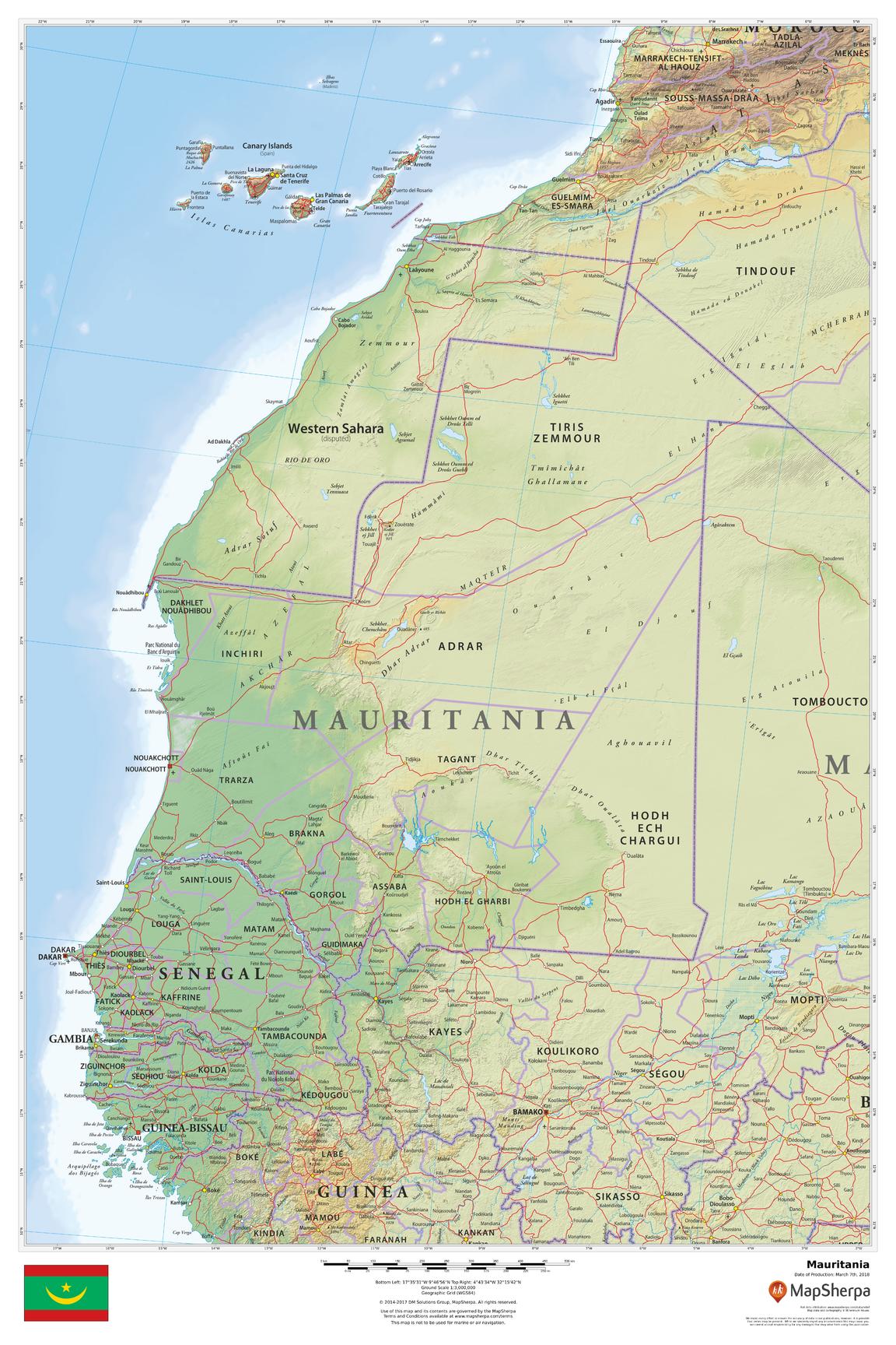
Explore the sweeping Sahara dunes, stone plateaus, and Atlantic coastline of Mauritania—from Nouakchott and Nouadhibou to the Senegal River and the remote Hodh regions. Clean political boundaries sit atop refined terrain shading so ergs, escarpments, and coastal lowlands read at a glance. Perfect for classrooms, offices, travel planning, and elegant home display.
🗺️ Map Features
-
Physical + Political Coverage – National borders, regions (where shown), major cities and towns—Nouakchott, Nouadhibou, Atar, Kiffa, Rosso—plus primary roads and rail.
-
Relief Shading & Elevation Tints – Hypsometric colours and hillshading distinguish the Adrar and Tagant plateaus, Aoukar basin, and the great sand seas of the Sahara.
-
Rivers, Coast & Wetlands – Clear depiction of the Senegal River, Atlantic shoreline, estuaries, and (where depicted) the wetlands of Banc d’Arguin National Park.
-
Notable Landforms (where shown) – Orientation to features such as the Richat Structure (Eye of the Sahara) for added geographic context.
-
Regional Context – Neighbouring Western Sahara, Algeria, Mali, and Senegal included for seamless continuity.
-
Wall-Optimised Cartography – Balanced label hierarchy and crisp symbology ensure clarity without clutter at typical viewing distances.
All features appear as depicted on the printed map.
✨ Available Finishes
| Format | Description |
|---|---|
| 📜 Paper (160 gsm) | Heavyweight matte-coated paper—perfect for framing under glass. |
| 🧼 Laminated (Encapsulated) | Fully sealed in 80-micron gloss laminate—durable, wipe-clean, great for notes. |
| 🪵 Laminated with Wooden Hang Rails | Laminated map mounted with lacquered natural timber rails (top & bottom) and a hanging cord—ready to display. |
| 🖼️ Canvas (395 gsm) | HP Professional Matte Canvas with archival pigment-based inks—rich texture, fade-resistant, gallery grade. |
| 🪵 Canvas with Wooden Hang Rails | Canvas finished with lacquered timber rails and a hanging cord—timeless, frame-free presentation. |
🔨 Hang-railed maps are made to order—please allow up to 10 working days for professional mounting.
📐 Specifications
| Feature | Detail |
|---|---|
| Title | Mauritania Wall Map |
| Map Type | Physical / Political |
| Scale | 1:3,000,000 (≈ 1 cm = 30 km) |
| Dimensions | 610 mm (W) × 914 mm (H) |
| Orientation | Portrait |
| Materials | Paper, Laminated, Canvas, With or Without Timber Rails |
| Printing | Archival pigment-based inks, fade-resistant |
💡 Why You’ll Love It
-
Desert-to-delta clarity—dunes, plateaus, basins, and river corridors rendered in elegant shaded relief.
-
Clear political framing supports teaching, logistics, and presentations.
-
Five premium finishes to suit homes, offices, classrooms, and studios.
-
Built to last—laminated/canvas options handle frequent use and keep colours true.
🚚 Delivery
-
Paper, Laminated & Canvas (rolled): Usually ships within 1–2 business days.
-
Hang-railed versions: Made to order; allow up to 10 working days.
-
Packaging: Securely protected to arrive in pristine condition.
Bring Mauritania’s Sahara horizons and Atlantic edge into daily focus. Choose your finish, hang with ease, and enjoy a map that’s both beautiful and deeply useful.
Original: $42.89
-65%$42.89
$15.01Product Information
Product Information
Shipping & Returns
Shipping & Returns
Description
Physical & Political Detail | Sahara & Atlantic Coast | Premium Finishes
Explore the sweeping Sahara dunes, stone plateaus, and Atlantic coastline of Mauritania—from Nouakchott and Nouadhibou to the Senegal River and the remote Hodh regions. Clean political boundaries sit atop refined terrain shading so ergs, escarpments, and coastal lowlands read at a glance. Perfect for classrooms, offices, travel planning, and elegant home display.
🗺️ Map Features
-
Physical + Political Coverage – National borders, regions (where shown), major cities and towns—Nouakchott, Nouadhibou, Atar, Kiffa, Rosso—plus primary roads and rail.
-
Relief Shading & Elevation Tints – Hypsometric colours and hillshading distinguish the Adrar and Tagant plateaus, Aoukar basin, and the great sand seas of the Sahara.
-
Rivers, Coast & Wetlands – Clear depiction of the Senegal River, Atlantic shoreline, estuaries, and (where depicted) the wetlands of Banc d’Arguin National Park.
-
Notable Landforms (where shown) – Orientation to features such as the Richat Structure (Eye of the Sahara) for added geographic context.
-
Regional Context – Neighbouring Western Sahara, Algeria, Mali, and Senegal included for seamless continuity.
-
Wall-Optimised Cartography – Balanced label hierarchy and crisp symbology ensure clarity without clutter at typical viewing distances.
All features appear as depicted on the printed map.
✨ Available Finishes
| Format | Description |
|---|---|
| 📜 Paper (160 gsm) | Heavyweight matte-coated paper—perfect for framing under glass. |
| 🧼 Laminated (Encapsulated) | Fully sealed in 80-micron gloss laminate—durable, wipe-clean, great for notes. |
| 🪵 Laminated with Wooden Hang Rails | Laminated map mounted with lacquered natural timber rails (top & bottom) and a hanging cord—ready to display. |
| 🖼️ Canvas (395 gsm) | HP Professional Matte Canvas with archival pigment-based inks—rich texture, fade-resistant, gallery grade. |
| 🪵 Canvas with Wooden Hang Rails | Canvas finished with lacquered timber rails and a hanging cord—timeless, frame-free presentation. |
🔨 Hang-railed maps are made to order—please allow up to 10 working days for professional mounting.
📐 Specifications
| Feature | Detail |
|---|---|
| Title | Mauritania Wall Map |
| Map Type | Physical / Political |
| Scale | 1:3,000,000 (≈ 1 cm = 30 km) |
| Dimensions | 610 mm (W) × 914 mm (H) |
| Orientation | Portrait |
| Materials | Paper, Laminated, Canvas, With or Without Timber Rails |
| Printing | Archival pigment-based inks, fade-resistant |
💡 Why You’ll Love It
-
Desert-to-delta clarity—dunes, plateaus, basins, and river corridors rendered in elegant shaded relief.
-
Clear political framing supports teaching, logistics, and presentations.
-
Five premium finishes to suit homes, offices, classrooms, and studios.
-
Built to last—laminated/canvas options handle frequent use and keep colours true.
🚚 Delivery
-
Paper, Laminated & Canvas (rolled): Usually ships within 1–2 business days.
-
Hang-railed versions: Made to order; allow up to 10 working days.
-
Packaging: Securely protected to arrive in pristine condition.
Bring Mauritania’s Sahara horizons and Atlantic edge into daily focus. Choose your finish, hang with ease, and enjoy a map that’s both beautiful and deeply useful.


