Melbourne & Region Hema 700 x 1000mm Laminated Wall Map with Hang Rails
Melbourne & Region — Hema (Laminated Wall Map + Hang Rails)
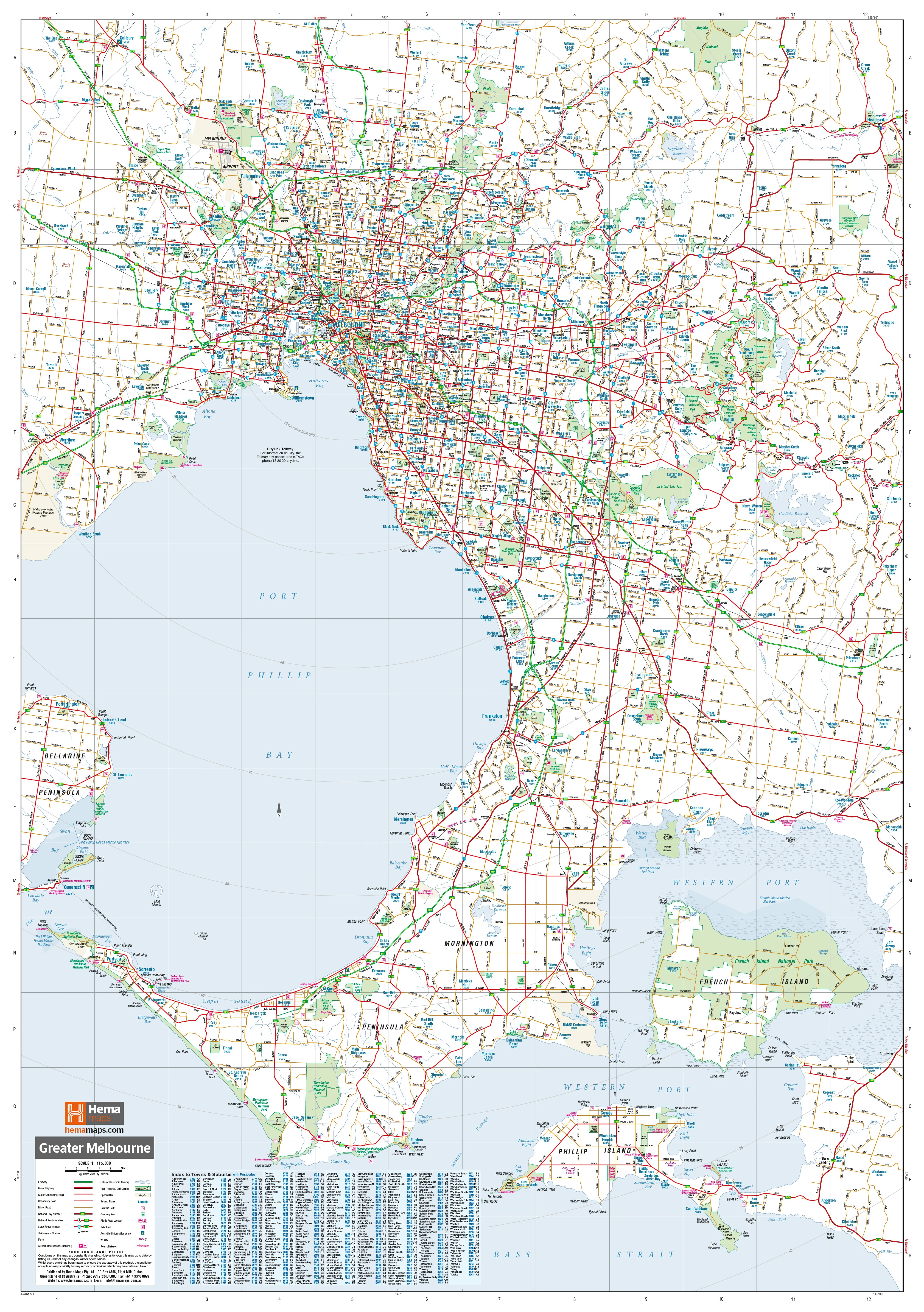
700 × 1000 mm • Scale 1:115,000 • Writable Laminate • Ready-to-Hang Timber Rails
A clear, business-ready wall map of Greater Melbourne—from Yan Yean (N) to Phillip Island (S) and Healesville (E) to Werribee (W). Ideal for planning, routing, sales territories, and team briefings.
🔍 At a Glance (What’s on the Map)
-
🛣️ Road hierarchy: All major & secondary roads with easy legibility at wall distance
-
🧭 Route numbering: Met routes, plus national & state route numbers for quick navigation
-
🚧 Freeways: Present corridors and future freeway alignments for forward planning
-
🧾 Postcodes: Complete postcode coverage—handy for sales and service areas
-
🏙️ Metro + peri-urban extent: Captures key growth fronts and commuter corridors
-
📏 Legend & scale: Clean symbology for instant interpretation
Clean cartography and tuned labels keep dense information readable—even from across the room.
Why This Map Works
-
Wall-readable clarity: Line weights, colour contrasts, and typography optimised for meeting rooms
-
Planning-ready: See the whole network at once—perfect for logistics, field ops, and sales
-
Easy collaboration: Writable, wipe-clean surface for quick mark-ups during stand-ups and reviews
-
Professional presentation: Rail-mounted finish suits offices, briefing rooms, and reception areas
🎨 Finish & Display
-
💧 Laminated (True Encapsulation)
-
Sealed in 2 × 80-micron gloss laminate (edge-sealed)
-
Waterproof • Tear-resistant • Wipe-clean
-
Use whiteboard markers and Mark-It-Dots; wipe away cleanly
-
-
🪵 Timber Hang Rails — Ready to Hang
-
Natural lacquered timber rails (top & bottom) with a top hanging cord
-
Neat, professional presentation—hang from a single hook
-
🧭 How Teams Use It
-
Sales & account teams: Define territories, visualise postcode coverage, track opportunities
-
Operations & logistics: Plan routes, depots, and service windows at a glance
-
Property & projects: Communicate portfolio spread and pipeline by corridor or postcode
-
Customer success & support: Map service calls and response zones for faster decisions
-
Leadership & comms: Align stakeholders quickly with a single shared view
Optional Add-Ons & Customisation
-
Branding & overlays: Add logos, territories, or custom symbols
-
Alternate sizes/formats: Talk to us about extended formats or companion region sheets
📐 Size & Scale
-
Size: 700 mm (W) × 1000 mm (H) • Portrait
-
Scale: 1:115,000
📊 Specifications
| Attribute | Details |
|---|---|
| Title | Melbourne & Region — Hema |
| Coverage | Yan Yean (N) to Phillip Island (S); Healesville (E) to Werribee (W) |
| Content | Major & secondary roads; met routes; national & state route numbers; present & future freeways; postcodes |
| Format | Laminated + Timber Hang Rails (true encapsulation; writable) |
| Laminate | 2 × 80-micron gloss |
| Rails | Natural timber, lacquered; top hanging cord |
| Size | 700 × 1000 mm |
| Scale | 1:115,000 |
🤝 Our Commitment
-
✅ Local craftsmanship: Printed and finished in Australia with tight colour management
-
✅ Built to last: True-encapsulation lamination stands up to daily handling
-
✅ Clarity first: Legends, symbols, and label hierarchies tuned for wall readability
-
✅ Packed with care: Hand-checked and securely shipped to arrive flat and display-ready
-
✅ Flexible options: We’ll tailor overlays, branding, or sizing to your workflow
Delivery: Custom hang-railed finish—please allow up to 10 working days.
🛒 Mount once, plan daily: a durable, ready-to-hang Melbourne metro map built for business.
Original: $178.83
-65%$178.83
$62.59Product Information
Product Information
Shipping & Returns
Shipping & Returns
Description
Melbourne & Region — Hema (Laminated Wall Map + Hang Rails)
700 × 1000 mm • Scale 1:115,000 • Writable Laminate • Ready-to-Hang Timber Rails
A clear, business-ready wall map of Greater Melbourne—from Yan Yean (N) to Phillip Island (S) and Healesville (E) to Werribee (W). Ideal for planning, routing, sales territories, and team briefings.
🔍 At a Glance (What’s on the Map)
-
🛣️ Road hierarchy: All major & secondary roads with easy legibility at wall distance
-
🧭 Route numbering: Met routes, plus national & state route numbers for quick navigation
-
🚧 Freeways: Present corridors and future freeway alignments for forward planning
-
🧾 Postcodes: Complete postcode coverage—handy for sales and service areas
-
🏙️ Metro + peri-urban extent: Captures key growth fronts and commuter corridors
-
📏 Legend & scale: Clean symbology for instant interpretation
Clean cartography and tuned labels keep dense information readable—even from across the room.
Why This Map Works
-
Wall-readable clarity: Line weights, colour contrasts, and typography optimised for meeting rooms
-
Planning-ready: See the whole network at once—perfect for logistics, field ops, and sales
-
Easy collaboration: Writable, wipe-clean surface for quick mark-ups during stand-ups and reviews
-
Professional presentation: Rail-mounted finish suits offices, briefing rooms, and reception areas
🎨 Finish & Display
-
💧 Laminated (True Encapsulation)
-
Sealed in 2 × 80-micron gloss laminate (edge-sealed)
-
Waterproof • Tear-resistant • Wipe-clean
-
Use whiteboard markers and Mark-It-Dots; wipe away cleanly
-
-
🪵 Timber Hang Rails — Ready to Hang
-
Natural lacquered timber rails (top & bottom) with a top hanging cord
-
Neat, professional presentation—hang from a single hook
-
🧭 How Teams Use It
-
Sales & account teams: Define territories, visualise postcode coverage, track opportunities
-
Operations & logistics: Plan routes, depots, and service windows at a glance
-
Property & projects: Communicate portfolio spread and pipeline by corridor or postcode
-
Customer success & support: Map service calls and response zones for faster decisions
-
Leadership & comms: Align stakeholders quickly with a single shared view
Optional Add-Ons & Customisation
-
Branding & overlays: Add logos, territories, or custom symbols
-
Alternate sizes/formats: Talk to us about extended formats or companion region sheets
📐 Size & Scale
-
Size: 700 mm (W) × 1000 mm (H) • Portrait
-
Scale: 1:115,000
📊 Specifications
| Attribute | Details |
|---|---|
| Title | Melbourne & Region — Hema |
| Coverage | Yan Yean (N) to Phillip Island (S); Healesville (E) to Werribee (W) |
| Content | Major & secondary roads; met routes; national & state route numbers; present & future freeways; postcodes |
| Format | Laminated + Timber Hang Rails (true encapsulation; writable) |
| Laminate | 2 × 80-micron gloss |
| Rails | Natural timber, lacquered; top hanging cord |
| Size | 700 × 1000 mm |
| Scale | 1:115,000 |
🤝 Our Commitment
-
✅ Local craftsmanship: Printed and finished in Australia with tight colour management
-
✅ Built to last: True-encapsulation lamination stands up to daily handling
-
✅ Clarity first: Legends, symbols, and label hierarchies tuned for wall readability
-
✅ Packed with care: Hand-checked and securely shipped to arrive flat and display-ready
-
✅ Flexible options: We’ll tailor overlays, branding, or sizing to your workflow
Delivery: Custom hang-railed finish—please allow up to 10 working days.
🛒 Mount once, plan daily: a durable, ready-to-hang Melbourne metro map built for business.


