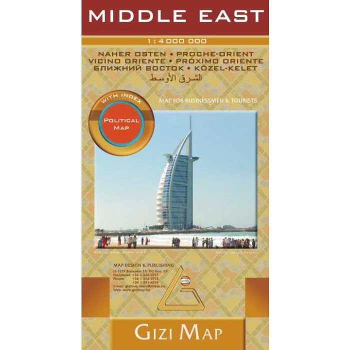
Middle East Gizi Maps folded map
Scale: 1:4,000,000
Format: Folded, single-sided road & physical map
Size (unfolded): 1000 mm x 930 mm
Publisher: Gizi Maps
ISBN: 9789638746573
Edition: Latest available
Printed in: Hungary
Made for: Travellers, researchers, teachers, and geopolitical explorers
🌍 Explore the Middle East with Clarity and Detail
This folded map of the Middle East by Gizi Maps offers a clear and informative overview of one of the world’s most historically and geopolitically significant regions. With detailed road networks, shaded relief terrain, and locations of tourist attractions and services, this map is both beautiful and highly functional.
Perfect for route planning, classroom use, or armchair travel, this single-sided map balances topographic detail with user-friendly design, making it ideal for both adventure and study.
🧭 Key Features
✔ Clear road network, including highways, main roads, and regional routes
✔ Relief shading and elevation colouring to represent mountain ranges and valleys
✔ Distances marked between major cities and junctions
✔ Tourist sites and service symbols – cultural landmarks, archaeological sites, airports, and more
✔ National borders, capital cities, major towns, rivers, and lakes
✔ Comprehensive place name index for fast reference
✔ Printed on durable paper for repeated unfolding and reference
✔ Folded format – lightweight and travel-friendly
🌐 Regional Coverage
Covers the core countries of the Middle East and surrounding regions, including but not limited to:
-
Turkey, Syria, Lebanon, Israel & Palestine, Jordan, Iraq, Iran
-
Saudi Arabia, UAE, Oman, Qatar, Bahrain, Kuwait, Yemen
-
Egypt, Cyprus, parts of North Africa, Afghanistan & Pakistan
This map provides an excellent regional overview—ideal for logistics, history, travel, and regional context.
📐 Product Specifications
| Feature | Details |
|---|---|
| Scale | 1:4,000,000 |
| Unfolded Size | 1000 mm x 930 mm |
| Format | Folded, single-sided |
| Index | Extensive place name index |
| Relief Style | Colour elevation shading |
| Publisher | Gizi Maps |
| Language | English |
| Country of Print | Hungary |
🛍️ Why Choose This Map?
🧳 Perfect for Travel Planning – Lightweight and informative
🧠 Excellent for Education – A clear teaching aid for geopolitics and geography
📚 Great Reference Tool – A must-have for researchers, libraries, and offices
🎁 Ideal Gift – For map collectors, globetrotters, and history lovers
🚚 Order & Delivery
This is an Order-on-Demand map.
🕐 Please allow up to 10 working days for delivery as we import this map directly from the publisher in Europe.
From the deserts of Arabia to the peaks of eastern Turkey, trace the movement of history and the complexity of the modern world with the Middle East Folded Map by Gizi Maps — a stunning combination of cartographic precision and visual clarity.
Original: $21.43
-65%$21.43
$7.50Product Information
Product Information
Shipping & Returns
Shipping & Returns
Description
Scale: 1:4,000,000
Format: Folded, single-sided road & physical map
Size (unfolded): 1000 mm x 930 mm
Publisher: Gizi Maps
ISBN: 9789638746573
Edition: Latest available
Printed in: Hungary
Made for: Travellers, researchers, teachers, and geopolitical explorers
🌍 Explore the Middle East with Clarity and Detail
This folded map of the Middle East by Gizi Maps offers a clear and informative overview of one of the world’s most historically and geopolitically significant regions. With detailed road networks, shaded relief terrain, and locations of tourist attractions and services, this map is both beautiful and highly functional.
Perfect for route planning, classroom use, or armchair travel, this single-sided map balances topographic detail with user-friendly design, making it ideal for both adventure and study.
🧭 Key Features
✔ Clear road network, including highways, main roads, and regional routes
✔ Relief shading and elevation colouring to represent mountain ranges and valleys
✔ Distances marked between major cities and junctions
✔ Tourist sites and service symbols – cultural landmarks, archaeological sites, airports, and more
✔ National borders, capital cities, major towns, rivers, and lakes
✔ Comprehensive place name index for fast reference
✔ Printed on durable paper for repeated unfolding and reference
✔ Folded format – lightweight and travel-friendly
🌐 Regional Coverage
Covers the core countries of the Middle East and surrounding regions, including but not limited to:
-
Turkey, Syria, Lebanon, Israel & Palestine, Jordan, Iraq, Iran
-
Saudi Arabia, UAE, Oman, Qatar, Bahrain, Kuwait, Yemen
-
Egypt, Cyprus, parts of North Africa, Afghanistan & Pakistan
This map provides an excellent regional overview—ideal for logistics, history, travel, and regional context.
📐 Product Specifications
| Feature | Details |
|---|---|
| Scale | 1:4,000,000 |
| Unfolded Size | 1000 mm x 930 mm |
| Format | Folded, single-sided |
| Index | Extensive place name index |
| Relief Style | Colour elevation shading |
| Publisher | Gizi Maps |
| Language | English |
| Country of Print | Hungary |
🛍️ Why Choose This Map?
🧳 Perfect for Travel Planning – Lightweight and informative
🧠 Excellent for Education – A clear teaching aid for geopolitics and geography
📚 Great Reference Tool – A must-have for researchers, libraries, and offices
🎁 Ideal Gift – For map collectors, globetrotters, and history lovers
🚚 Order & Delivery
This is an Order-on-Demand map.
🕐 Please allow up to 10 working days for delivery as we import this map directly from the publisher in Europe.
From the deserts of Arabia to the peaks of eastern Turkey, trace the movement of history and the complexity of the modern world with the Middle East Folded Map by Gizi Maps — a stunning combination of cartographic precision and visual clarity.