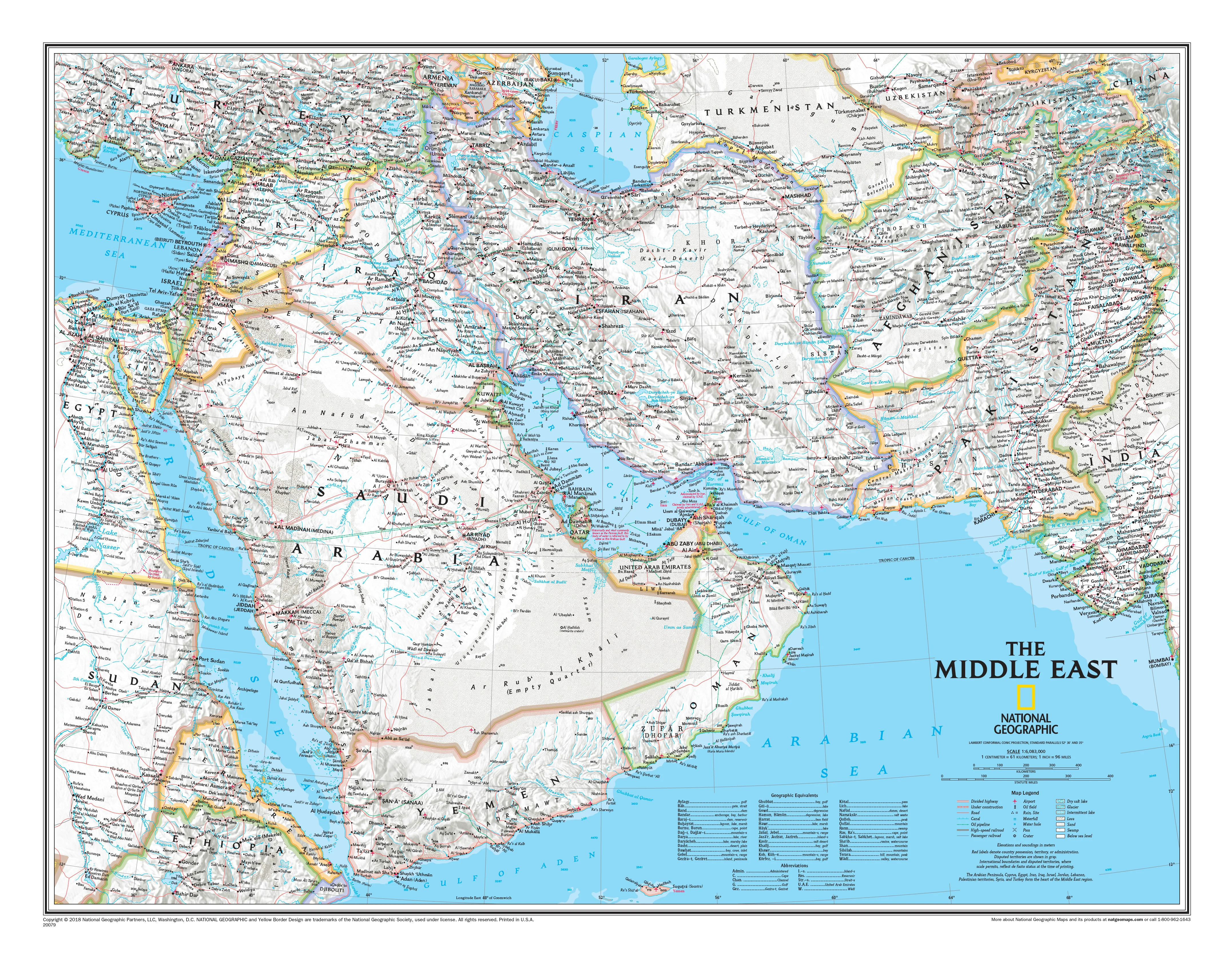
Middle East National Geographic 1450 x 1130mm Wall Map
Political Detail with Shaded Relief | Large-Format Reference | Premium Finishes
An expansive, authoritative portrait of one of the world’s most consequential regions—rendered with the clarity, balance, and cartographic excellence that define National Geographic.
Stretching from North Africa and the eastern Mediterranean across the Fertile Crescent to Central Asia, this map captures a region where continents converge, civilisations emerged, and modern geopolitics continues to unfold. Every element—borders, cities, rivers, deserts, and mountain systems—is presented with precision, while subtle shaded relief adds depth and realism without compromising legibility.
This is a map designed to inform, impress, and endure—equally suited to education, strategic reference, travel planning, or refined wall display.
⚓ Why This Map Stands Out
A region of global significance
From ancient trade routes to modern energy corridors, the Middle East remains central to world history, commerce, and geopolitics.
National Geographic authority
Renowned for accuracy, balance, and visual clarity, this map reflects decades of cartographic expertise.
Political clarity with geographic depth
Country borders, capitals, and major cities are paired with terrain features—creating a complete spatial understanding.
Shaded relief that enhances—not overwhelms
Mountain ranges, plateaus, and desert basins are subtly modelled for depth while maintaining readability.
A statement wall piece
Large-format scale and refined colour palette make this as visually compelling as it is informative.
🗺️ What the Map Shows
- The core Middle East region in rich political and physical detail
- Countries including Iran, Iraq, Saudi Arabia, Israel, Jordan, UAE, Oman, Yemen, Qatar, Kuwait, and beyond
- Extended coverage from Egypt and the eastern Mediterranean through to Afghanistan and Pakistan
- Surrounding regions of Turkey, Central Asia, and parts of India and China
- Major cities, transport corridors, rivers, deserts, and mountain systems
- A clear geographic framework for understanding regional relationships, borders, and terrain
📐 Size
1450 mm (W) × 1130 mm (H)
A substantial wall format that delivers excellent readability without overwhelming the room—ideal for offices, classrooms, and living spaces.
✨ Premium Finishes
| Format | Description |
|---|---|
| 📜 Paper (160 gsm) | Heavyweight matte-coated paper—ideal for framing under glass with crisp detail and a smooth, non-reflective finish. |
| 🧼 Laminated (Encapsulated) | Fully sealed in 2 × 80-micron gloss laminate. Durable, tear-resistant, and wipe-clean—perfect for frequent handling or annotation. |
| 🪵 Laminated + Timber Hang Rails | Laminated map fitted with lacquered natural timber rails (top & bottom) and hanging cord—ready to display. |
| 🖼️ Canvas (395 gsm HP Professional Matte) | Printed with archival pigment-based inks on premium canvas. Rich texture, low glare, and gallery-quality presentation. |
| 🪵 Canvas + Timber Hang Rails | Canvas paired with timber rails for a refined, frame-free display solution with timeless appeal. |
🔨 Please allow up to 10 working days for professionally mounted hang-railed finishes.
📊 Specifications
| Feature | Detail |
|---|---|
| Title | Middle East — National Geographic Wall Map |
| Dimensions | 1450 mm (W) × 1130 mm (H) |
| Map Type | Political with shaded relief |
| Coverage | Middle East, North Africa, and Central Asia |
| Materials | 160 gsm matte paper / 2 × 80-micron laminate / 395 gsm HP Professional Matte Canvas |
| Printing | Pigment-based, fade-resistant inks |
| Origin | Printed and finished in Australia |
🎯 Ideal For
- Offices and boardrooms needing a clear regional reference
- Classrooms and universities teaching history, geography, or geopolitics
- Travellers and researchers planning across multiple countries
- Collectors of National Geographic cartography
- Interior spaces seeking a refined, intellectually engaging focal point
🤝 Our Commitment
- Printed in Australia using archival methods
- Premium materials only—from heavyweight paper to museum-grade canvas
- Colour-managed for clarity at large scale
- Hand-checked and carefully packed for safe delivery
- Built to deliver long-term durability and visual impact
🚚 Delivery
- Paper, Laminated, Canvas (rolled): Dispatch in 1–2 business days
- Hang-Railed Maps: Made to order—allow up to 10 working days
- Packaging: Securely rolled and protected for safe arrival
Bring the history, geography, and strategic significance of the Middle East into sharp focus with a wall map that is as informative as it is visually striking.
👉 Order now and elevate your space with world-class cartography.
Original: $128.75
-65%$128.75
$45.06Product Information
Product Information
Shipping & Returns
Shipping & Returns
Description
Political Detail with Shaded Relief | Large-Format Reference | Premium Finishes
An expansive, authoritative portrait of one of the world’s most consequential regions—rendered with the clarity, balance, and cartographic excellence that define National Geographic.
Stretching from North Africa and the eastern Mediterranean across the Fertile Crescent to Central Asia, this map captures a region where continents converge, civilisations emerged, and modern geopolitics continues to unfold. Every element—borders, cities, rivers, deserts, and mountain systems—is presented with precision, while subtle shaded relief adds depth and realism without compromising legibility.
This is a map designed to inform, impress, and endure—equally suited to education, strategic reference, travel planning, or refined wall display.
⚓ Why This Map Stands Out
A region of global significance
From ancient trade routes to modern energy corridors, the Middle East remains central to world history, commerce, and geopolitics.
National Geographic authority
Renowned for accuracy, balance, and visual clarity, this map reflects decades of cartographic expertise.
Political clarity with geographic depth
Country borders, capitals, and major cities are paired with terrain features—creating a complete spatial understanding.
Shaded relief that enhances—not overwhelms
Mountain ranges, plateaus, and desert basins are subtly modelled for depth while maintaining readability.
A statement wall piece
Large-format scale and refined colour palette make this as visually compelling as it is informative.
🗺️ What the Map Shows
- The core Middle East region in rich political and physical detail
- Countries including Iran, Iraq, Saudi Arabia, Israel, Jordan, UAE, Oman, Yemen, Qatar, Kuwait, and beyond
- Extended coverage from Egypt and the eastern Mediterranean through to Afghanistan and Pakistan
- Surrounding regions of Turkey, Central Asia, and parts of India and China
- Major cities, transport corridors, rivers, deserts, and mountain systems
- A clear geographic framework for understanding regional relationships, borders, and terrain
📐 Size
1450 mm (W) × 1130 mm (H)
A substantial wall format that delivers excellent readability without overwhelming the room—ideal for offices, classrooms, and living spaces.
✨ Premium Finishes
| Format | Description |
|---|---|
| 📜 Paper (160 gsm) | Heavyweight matte-coated paper—ideal for framing under glass with crisp detail and a smooth, non-reflective finish. |
| 🧼 Laminated (Encapsulated) | Fully sealed in 2 × 80-micron gloss laminate. Durable, tear-resistant, and wipe-clean—perfect for frequent handling or annotation. |
| 🪵 Laminated + Timber Hang Rails | Laminated map fitted with lacquered natural timber rails (top & bottom) and hanging cord—ready to display. |
| 🖼️ Canvas (395 gsm HP Professional Matte) | Printed with archival pigment-based inks on premium canvas. Rich texture, low glare, and gallery-quality presentation. |
| 🪵 Canvas + Timber Hang Rails | Canvas paired with timber rails for a refined, frame-free display solution with timeless appeal. |
🔨 Please allow up to 10 working days for professionally mounted hang-railed finishes.
📊 Specifications
| Feature | Detail |
|---|---|
| Title | Middle East — National Geographic Wall Map |
| Dimensions | 1450 mm (W) × 1130 mm (H) |
| Map Type | Political with shaded relief |
| Coverage | Middle East, North Africa, and Central Asia |
| Materials | 160 gsm matte paper / 2 × 80-micron laminate / 395 gsm HP Professional Matte Canvas |
| Printing | Pigment-based, fade-resistant inks |
| Origin | Printed and finished in Australia |
🎯 Ideal For
- Offices and boardrooms needing a clear regional reference
- Classrooms and universities teaching history, geography, or geopolitics
- Travellers and researchers planning across multiple countries
- Collectors of National Geographic cartography
- Interior spaces seeking a refined, intellectually engaging focal point
🤝 Our Commitment
- Printed in Australia using archival methods
- Premium materials only—from heavyweight paper to museum-grade canvas
- Colour-managed for clarity at large scale
- Hand-checked and carefully packed for safe delivery
- Built to deliver long-term durability and visual impact
🚚 Delivery
- Paper, Laminated, Canvas (rolled): Dispatch in 1–2 business days
- Hang-Railed Maps: Made to order—allow up to 10 working days
- Packaging: Securely rolled and protected for safe arrival
Bring the history, geography, and strategic significance of the Middle East into sharp focus with a wall map that is as informative as it is visually striking.
👉 Order now and elevate your space with world-class cartography.