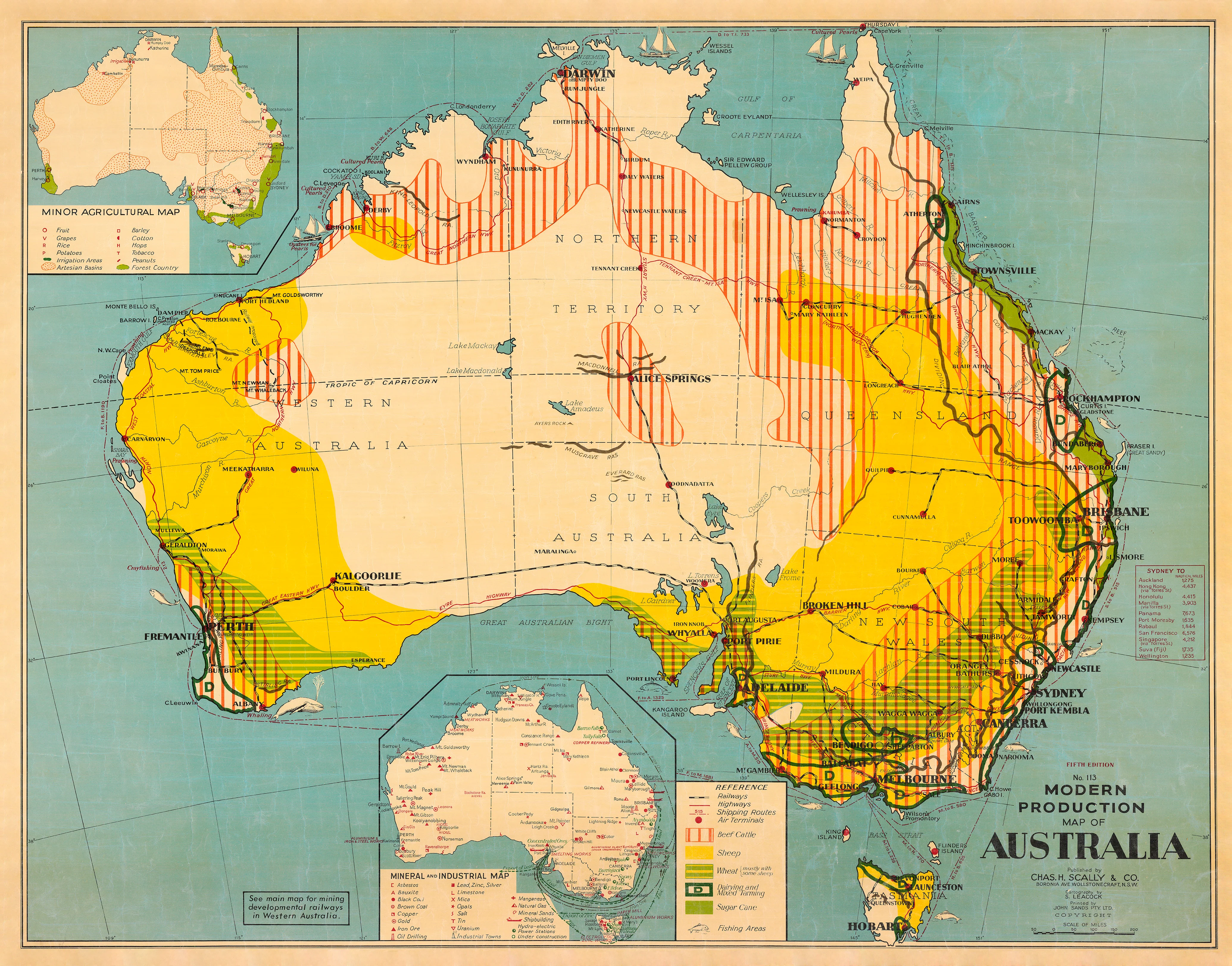
Modern Production Map of Australia 1963 cartography by S. Leacock
🇦🇺 Modern Production Map of Australia – 1963
A Mid-Century Portrait of Australian Industry and Agriculture
Cartography by S. Leacock
Step back into the dynamic post-war era of the 1960s with this beautifully restored Modern Production Map of Australia, originally designed by celebrated cartographer S. Leacock in 1963. This map is more than a historical snapshot—it’s a visual celebration of Australia’s industrial progress, agricultural output, and national infrastructure at a time of innovation and expansion.
Ideal for educators, collectors, historians, and anyone passionate about Australia’s economic history, this map captures the heartbeat of a nation that was booming with productivity—from wheat belts and cattle stations to mining regions and manufacturing hubs.
🏭 What's Displayed
S. Leacock’s meticulous cartographic work showcases a fascinating cross-section of Australia's mid-century production economy:
-
Primary Industry Zones:
-
Wheat, wool, sugar cane, dairy and beef cattle regions
-
Mixed farming, forestry, fishing and fruit production
-
Key industrial centres and transport hubs
-
-
Infrastructure & Trade Routes:
-
National and state highways
-
Railway systems and key freight lines
-
Shipping routes and export ports
-
Air terminals and early aviation routes
-
-
Production Icons:
-
Regionally placed pictograms representing products and industries
-
Colour-coded land use areas for easy reference
-
Tables and charts summarising national outputs and economic indicators
-
This map is both a powerful educational tool and a beautifully nostalgic decorative piece—perfect for classrooms, libraries, offices, or rural homes.
🖼️ Available Finishes
Choose the format that best suits your needs or décor style:
| Finish | Description |
|---|---|
| Paper (160 gsm) | Archival-quality heavyweight stock—ideal for traditional framing under glass. |
| Laminated | Fully encapsulated in gloss 80-micron laminate. Waterproof, markable, and durable. |
| Laminated with Hang Rails | Includes top and bottom wooden rails and hanging cord—ready for wall display. |
| Canvas (395 gsm) | Printed on HP Professional Matte Canvas using fade-resistant pigment inks. Museum-grade quality. |
| Canvas with Hang Rails | A gallery-style finish with natural timber hang rails and cord—ready to hang with ease. |
⏳ Please allow up to 10 working days for framed hang-rail options, which are custom-finished by our in-house framer.
📐 Specifications
| Feature | Details |
|---|---|
| Map Title | Modern Production Map of Australia |
| Cartographer | S. Leacock |
| Year of Publication | 1963 |
| Dimensions | 1100 mm (H) × 860 mm (W) (approx.) |
| Projection | Thematic mid-century geographic |
| Printing Method | High-resolution digital restoration |
| Canvas Material | 395 gsm HP Matte Canvas |
| Paper Material | 160 gsm archival paper |
| Lamination | Gloss 80-micron encapsulation |
| Made in | Australia |
🎯 Who Will Love This Map
✔️ Educators & Students – A tangible way to explore Australia's 20th-century economy
✔️ Historians & Archivists – A significant mid-century production reference
✔️ Farmers & Regional Planners – See how your region was represented 60 years ago
✔️ Collectors & Decorators – Vintage charm that sparks conversation
✔️ Business Owners & Analysts – Explore how infrastructure and trade have evolved
🌟 Why Choose This Map
-
📚 Historically Significant – A rare and beautifully detailed depiction of 1960s Australia
-
🖼️ Display-Ready – Choose from multiple finishes to suit your interior aesthetic
-
💡 Educational & Insightful – Perfect for understanding the development of modern Australia
-
💎 Crafted to Last – Premium print materials and optional framing ensure long-term enjoyment
🇦🇺 From wheat fields to wharves, railroads to refineries—this map is a powerful portrait of a nation on the move. S. Leacock’s 1963 Modern Production Map of Australia brings our industrial story to life with grace, colour, and cartographic finesse
Original: $64.36
-65%$64.36
$22.53Product Information
Product Information
Shipping & Returns
Shipping & Returns
Description
🇦🇺 Modern Production Map of Australia – 1963
A Mid-Century Portrait of Australian Industry and Agriculture
Cartography by S. Leacock
Step back into the dynamic post-war era of the 1960s with this beautifully restored Modern Production Map of Australia, originally designed by celebrated cartographer S. Leacock in 1963. This map is more than a historical snapshot—it’s a visual celebration of Australia’s industrial progress, agricultural output, and national infrastructure at a time of innovation and expansion.
Ideal for educators, collectors, historians, and anyone passionate about Australia’s economic history, this map captures the heartbeat of a nation that was booming with productivity—from wheat belts and cattle stations to mining regions and manufacturing hubs.
🏭 What's Displayed
S. Leacock’s meticulous cartographic work showcases a fascinating cross-section of Australia's mid-century production economy:
-
Primary Industry Zones:
-
Wheat, wool, sugar cane, dairy and beef cattle regions
-
Mixed farming, forestry, fishing and fruit production
-
Key industrial centres and transport hubs
-
-
Infrastructure & Trade Routes:
-
National and state highways
-
Railway systems and key freight lines
-
Shipping routes and export ports
-
Air terminals and early aviation routes
-
-
Production Icons:
-
Regionally placed pictograms representing products and industries
-
Colour-coded land use areas for easy reference
-
Tables and charts summarising national outputs and economic indicators
-
This map is both a powerful educational tool and a beautifully nostalgic decorative piece—perfect for classrooms, libraries, offices, or rural homes.
🖼️ Available Finishes
Choose the format that best suits your needs or décor style:
| Finish | Description |
|---|---|
| Paper (160 gsm) | Archival-quality heavyweight stock—ideal for traditional framing under glass. |
| Laminated | Fully encapsulated in gloss 80-micron laminate. Waterproof, markable, and durable. |
| Laminated with Hang Rails | Includes top and bottom wooden rails and hanging cord—ready for wall display. |
| Canvas (395 gsm) | Printed on HP Professional Matte Canvas using fade-resistant pigment inks. Museum-grade quality. |
| Canvas with Hang Rails | A gallery-style finish with natural timber hang rails and cord—ready to hang with ease. |
⏳ Please allow up to 10 working days for framed hang-rail options, which are custom-finished by our in-house framer.
📐 Specifications
| Feature | Details |
|---|---|
| Map Title | Modern Production Map of Australia |
| Cartographer | S. Leacock |
| Year of Publication | 1963 |
| Dimensions | 1100 mm (H) × 860 mm (W) (approx.) |
| Projection | Thematic mid-century geographic |
| Printing Method | High-resolution digital restoration |
| Canvas Material | 395 gsm HP Matte Canvas |
| Paper Material | 160 gsm archival paper |
| Lamination | Gloss 80-micron encapsulation |
| Made in | Australia |
🎯 Who Will Love This Map
✔️ Educators & Students – A tangible way to explore Australia's 20th-century economy
✔️ Historians & Archivists – A significant mid-century production reference
✔️ Farmers & Regional Planners – See how your region was represented 60 years ago
✔️ Collectors & Decorators – Vintage charm that sparks conversation
✔️ Business Owners & Analysts – Explore how infrastructure and trade have evolved
🌟 Why Choose This Map
-
📚 Historically Significant – A rare and beautifully detailed depiction of 1960s Australia
-
🖼️ Display-Ready – Choose from multiple finishes to suit your interior aesthetic
-
💡 Educational & Insightful – Perfect for understanding the development of modern Australia
-
💎 Crafted to Last – Premium print materials and optional framing ensure long-term enjoyment
🇦🇺 From wheat fields to wharves, railroads to refineries—this map is a powerful portrait of a nation on the move. S. Leacock’s 1963 Modern Production Map of Australia brings our industrial story to life with grace, colour, and cartographic finesse


