Mount Everest 50th Anniversary Wall Map (Side B) by National Geographic
Topographic & Expedition Map | Sagarmatha National Park & Everest Routes | Wall Format (791 × 511 mm) | Premium Finishes
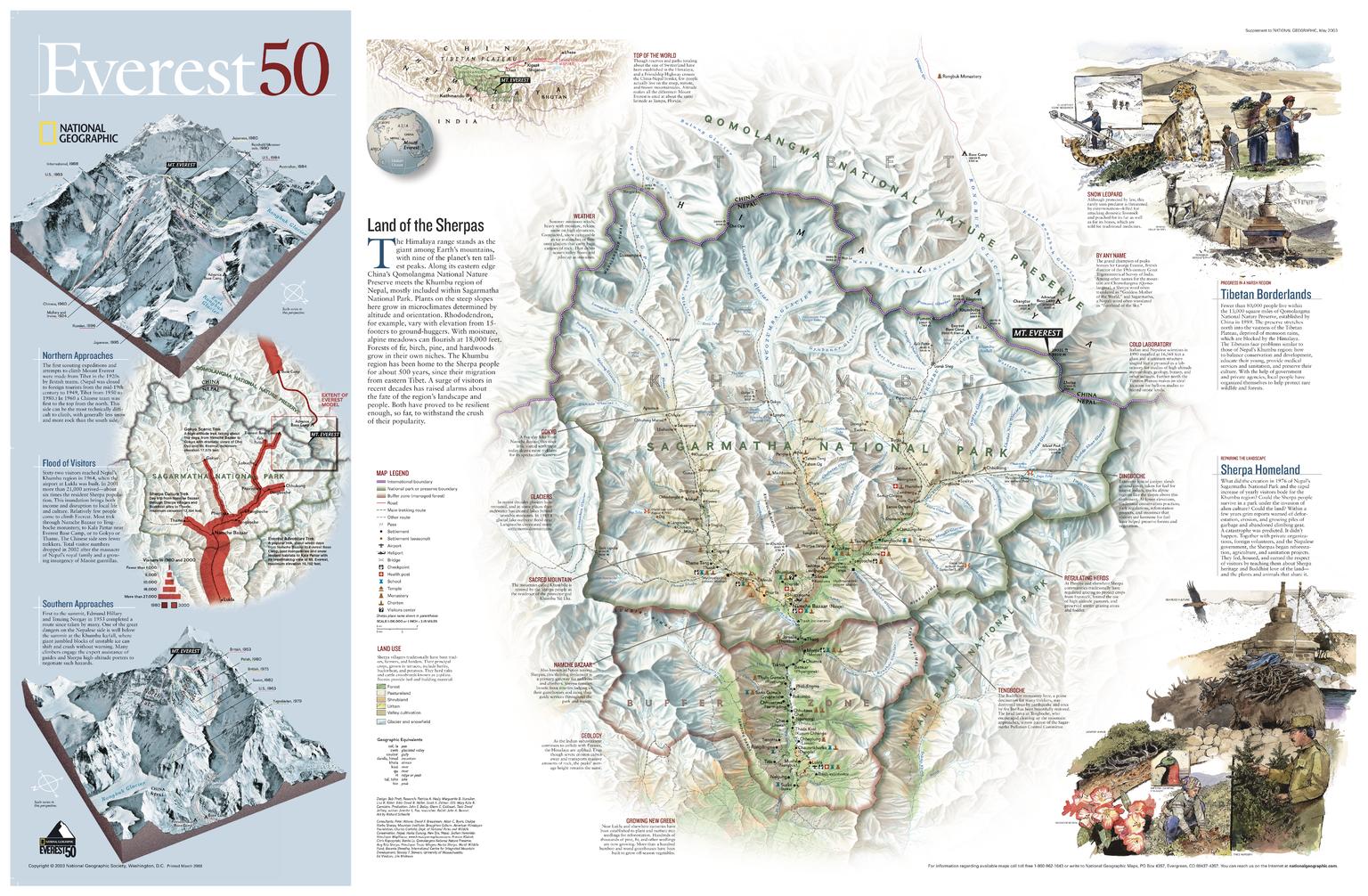
A remarkable companion to the anniversary edition celebrating the first ascent of Mount Everest, this Side B map turns its focus to the landscape surrounding the world’s highest peak. Published by National Geographic, it presents a richly detailed view of Sagarmatha National Park and the greater Everest region—where culture, terrain, and exploration converge.
Designed to complement the digital elevation model on Side A, this map offers a ground-level perspective of the routes, people, and places that define Everest.
Why This Map Stands Out
A complete Everest perspective
Pairs with Side A to deliver both scientific and geographic views of the region.
Expedition-focused detail
Highlights the routes taken by historic climbs and modern expeditions.
Cultural and environmental insight
Explores the role of Sherpa communities and protected landscapes.
Richly annotated
Includes inset maps and informative sidebars for deeper understanding.
A striking wall map
Ideal for both mountaineering enthusiasts and collectors.
🗺️ What the Map Shows
- Detailed mapping of Sagarmatha National Park and surrounding Himalayan terrain
- The position and structure of Mount Everest within the region
- Major expedition routes used by climbers over time
- Key locations including base camps, passes, and settlements
- Inset maps providing additional regional and route context
- Informative panels covering:
- The Sherpa people and their culture
- Growth in tourism and climbing activity
- Notable expeditions and historic ascents
📐 Size & Format
791 mm (W) × 511 mm (H)
Landscape orientation
A versatile format ideal for:
- Classrooms and geography education
- Home offices and studies
- Mountaineering and adventure displays
- Feature walls celebrating exploration
✨ Premium Finishes
| Format | Description |
|---|---|
| 📜 Paper (160 gsm) | Heavyweight matte-coated paper—ideal for framing. Preserves fine topographic detail. |
| 🧼 Laminated (Encapsulated) | Sealed in 2 × 80-micron gloss laminate. Durable, wipe-clean, and suitable for reference use. |
| 🪵 Laminated + Timber Hang Rails | Laminated map mounted with lacquered natural timber rails and hanging cord—ready to display. |
| 🖼️ Canvas (395 gsm HP Professional Matte) | Printed with archival pigment inks. Enhances relief and depth. |
| 🪵 Canvas + Timber Hang Rails | Canvas paired with timber rails for a gallery-style presentation. |
🔨 Please allow up to 10 working days for professionally mounted hang-railed finishes.
📊 Specifications
| Feature | Detail |
|---|---|
| Title | Mount Everest 50th Anniversary — Side B |
| Publisher | National Geographic |
| Published | 2010 |
| Scale | 1:90,000 |
| Dimensions | 791 mm × 511 mm |
| Orientation | Landscape |
| Map Type | Topographic / Thematic |
| Coverage | Sagarmatha National Park & Everest Region |
| Materials | 160 gsm matte paper / 2 × 80-micron laminate / 395 gsm HP Professional Matte Canvas |
| Printing | Pigment-based, fade-resistant inks |
| Origin | Printed in Australia |
🎯 Ideal For
- Mountaineers and Everest enthusiasts
- Students and educators of geography and high-altitude environments
- Collectors of National Geographic exploration maps
- Interiors seeking a bold, adventure-inspired display piece
- Gift buyers looking for a unique and meaningful map
🏔️ The World Around Everest
Beyond the summit lies a landscape of:
- Glaciers, valleys, and towering Himalayan peaks
- Communities shaped by altitude and tradition
- Routes forged by generations of climbers
- A fragile environment under increasing pressure
This map captures that world—offering a clear and compelling view of the region where human ambition meets the highest point on Earth.
🤝 Our Commitment
- Printed in Australia using archival-quality production
- Faithfully reproduced to preserve clarity and topographic detail
- Premium materials selected for durability and longevity
- Each map is hand-checked before dispatch
- Carefully packaged for safe delivery
🚚 Delivery
- Paper, Laminated, Canvas (rolled): Dispatch within 1–2 business days
- Hang-Railed Maps: Made to order—allow up to 10 working days
- Packaging: Securely rolled in protective tubing
Explore the world beneath Everest’s summit—
a map that brings the Himalayan landscape and its stories into focus.
👉 Order now and complete the Everest anniversary set.
Original: $57.20
-65%$57.20
$20.02Product Information
Product Information
Shipping & Returns
Shipping & Returns
Description
Topographic & Expedition Map | Sagarmatha National Park & Everest Routes | Wall Format (791 × 511 mm) | Premium Finishes
A remarkable companion to the anniversary edition celebrating the first ascent of Mount Everest, this Side B map turns its focus to the landscape surrounding the world’s highest peak. Published by National Geographic, it presents a richly detailed view of Sagarmatha National Park and the greater Everest region—where culture, terrain, and exploration converge.
Designed to complement the digital elevation model on Side A, this map offers a ground-level perspective of the routes, people, and places that define Everest.
Why This Map Stands Out
A complete Everest perspective
Pairs with Side A to deliver both scientific and geographic views of the region.
Expedition-focused detail
Highlights the routes taken by historic climbs and modern expeditions.
Cultural and environmental insight
Explores the role of Sherpa communities and protected landscapes.
Richly annotated
Includes inset maps and informative sidebars for deeper understanding.
A striking wall map
Ideal for both mountaineering enthusiasts and collectors.
🗺️ What the Map Shows
- Detailed mapping of Sagarmatha National Park and surrounding Himalayan terrain
- The position and structure of Mount Everest within the region
- Major expedition routes used by climbers over time
- Key locations including base camps, passes, and settlements
- Inset maps providing additional regional and route context
- Informative panels covering:
- The Sherpa people and their culture
- Growth in tourism and climbing activity
- Notable expeditions and historic ascents
📐 Size & Format
791 mm (W) × 511 mm (H)
Landscape orientation
A versatile format ideal for:
- Classrooms and geography education
- Home offices and studies
- Mountaineering and adventure displays
- Feature walls celebrating exploration
✨ Premium Finishes
| Format | Description |
|---|---|
| 📜 Paper (160 gsm) | Heavyweight matte-coated paper—ideal for framing. Preserves fine topographic detail. |
| 🧼 Laminated (Encapsulated) | Sealed in 2 × 80-micron gloss laminate. Durable, wipe-clean, and suitable for reference use. |
| 🪵 Laminated + Timber Hang Rails | Laminated map mounted with lacquered natural timber rails and hanging cord—ready to display. |
| 🖼️ Canvas (395 gsm HP Professional Matte) | Printed with archival pigment inks. Enhances relief and depth. |
| 🪵 Canvas + Timber Hang Rails | Canvas paired with timber rails for a gallery-style presentation. |
🔨 Please allow up to 10 working days for professionally mounted hang-railed finishes.
📊 Specifications
| Feature | Detail |
|---|---|
| Title | Mount Everest 50th Anniversary — Side B |
| Publisher | National Geographic |
| Published | 2010 |
| Scale | 1:90,000 |
| Dimensions | 791 mm × 511 mm |
| Orientation | Landscape |
| Map Type | Topographic / Thematic |
| Coverage | Sagarmatha National Park & Everest Region |
| Materials | 160 gsm matte paper / 2 × 80-micron laminate / 395 gsm HP Professional Matte Canvas |
| Printing | Pigment-based, fade-resistant inks |
| Origin | Printed in Australia |
🎯 Ideal For
- Mountaineers and Everest enthusiasts
- Students and educators of geography and high-altitude environments
- Collectors of National Geographic exploration maps
- Interiors seeking a bold, adventure-inspired display piece
- Gift buyers looking for a unique and meaningful map
🏔️ The World Around Everest
Beyond the summit lies a landscape of:
- Glaciers, valleys, and towering Himalayan peaks
- Communities shaped by altitude and tradition
- Routes forged by generations of climbers
- A fragile environment under increasing pressure
This map captures that world—offering a clear and compelling view of the region where human ambition meets the highest point on Earth.
🤝 Our Commitment
- Printed in Australia using archival-quality production
- Faithfully reproduced to preserve clarity and topographic detail
- Premium materials selected for durability and longevity
- Each map is hand-checked before dispatch
- Carefully packaged for safe delivery
🚚 Delivery
- Paper, Laminated, Canvas (rolled): Dispatch within 1–2 business days
- Hang-Railed Maps: Made to order—allow up to 10 working days
- Packaging: Securely rolled in protective tubing
Explore the world beneath Everest’s summit—
a map that brings the Himalayan landscape and its stories into focus.
👉 Order now and complete the Everest anniversary set.


