Mozambique Wall Map 610 x 914mm
Physical & Political Detail | Indian Ocean Coastline | Premium Finishes
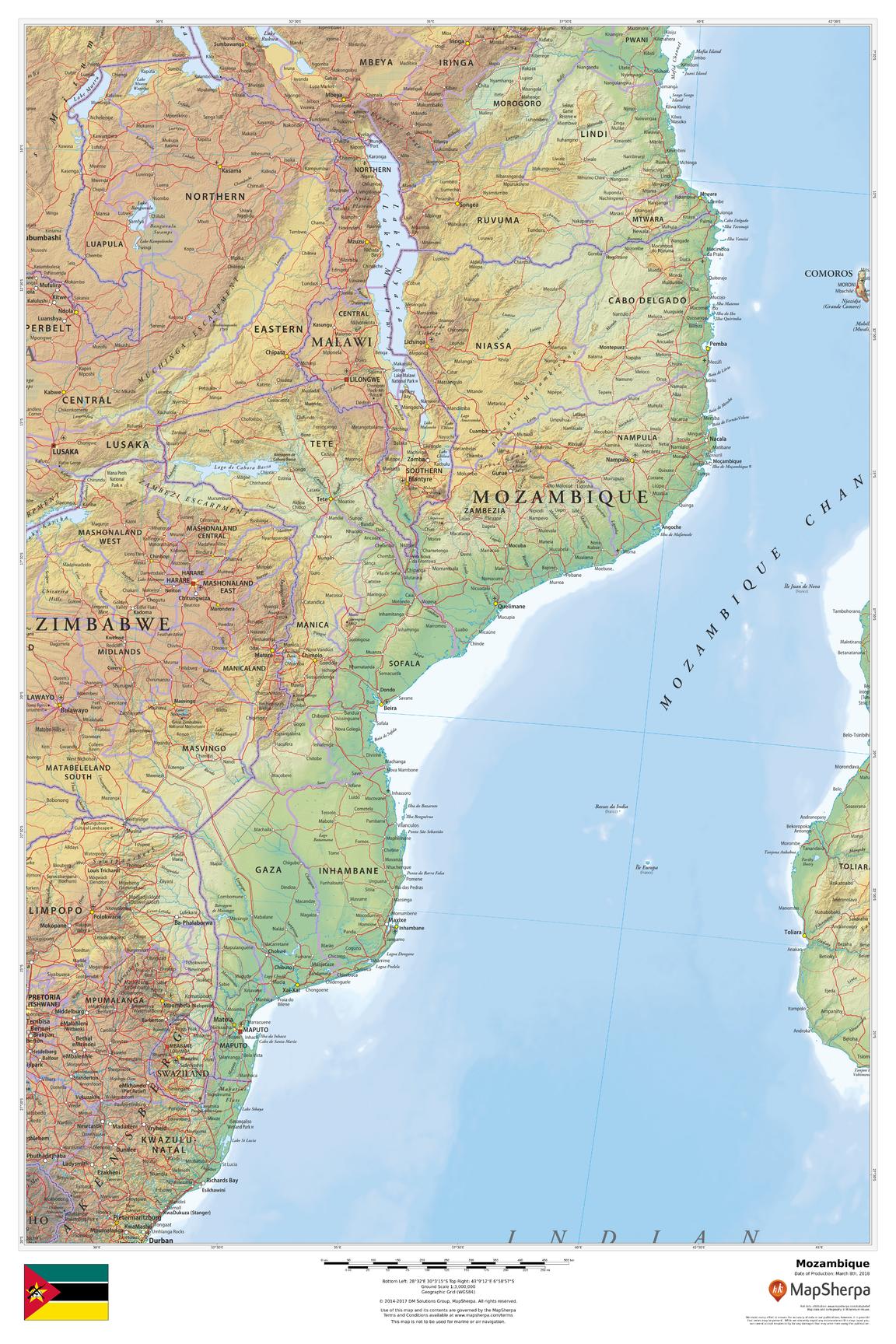
Experience Mozambique in elegant wall-ready clarity—from the turquoise curve of the Mozambique Channel and the Bazaruto and Quirimbas archipelagos to the inland Zambezi and Limpopo river systems. Clean political boundaries overlay refined terrain shading so coastal plains, central highlands, and escarpments read at a glance. Ideal for classrooms, offices, travel planning, and stylish home display.
🗺️ Map Features
-
Physical + Political Coverage – National borders, provinces (where shown), major cities and towns—Maputo, Beira, Nampula, Pemba, Tete, Nacala—plus primary roads and rail.
-
Relief Shading & Elevation Tints – Hypsometric colours and hillshading highlight coastal lowlands, central plateaus, and ranges along the Lebombo and Chimanimani areas.
-
Rivers, Lakes & Coast – Clear depiction of the Zambezi and Limpopo corridors, Lake Malawi/Nyasa, estuaries, and key bays and ports for full geographic context.
-
Parks & Heritage (where shown) – Orientation to Gorongosa National Park, Bazaruto & Quirimbas archipelagos, and Ilha de Moçambique.
-
Regional Context – Neighbouring South Africa, Eswatini, Zimbabwe, Zambia, Malawi, and Tanzania included for seamless continuity.
-
Wall-Optimised Cartography – Balanced label hierarchy and crisp symbology ensure clarity without clutter at typical viewing distances.
All features appear as depicted on the printed map.
✨ Available Finishes
| Format | Description |
|---|---|
| 📜 Paper (160 gsm) | Heavyweight matte-coated paper—perfect for framing under glass. |
| 🧼 Laminated (Encapsulated) | Fully sealed in 80-micron gloss laminate—durable, wipe-clean, great for notes. |
| 🪵 Laminated with Wooden Hang Rails | Laminated map mounted with lacquered natural timber rails (top & bottom) and a hanging cord—ready to display. |
| 🖼️ Canvas (395 gsm) | HP Professional Matte Canvas with archival pigment-based inks—rich texture, fade-resistant, gallery grade. |
| 🪵 Canvas with Wooden Hang Rails | Canvas finished with lacquered timber rails and a hanging cord—timeless, frame-free presentation. |
🔨 Hang-railed maps are made to order—please allow up to 10 working days for professional mounting.
📐 Specifications
| Feature | Detail |
|---|---|
| Title | Mozambique Wall Map |
| Map Type | Physical / Political |
| Scale | 1:3,000,000 (≈ 1 cm = 30 km) |
| Dimensions | 610 mm (W) × 914 mm (H) |
| Orientation | Portrait |
| Materials | Paper, Laminated, Canvas, With or Without Timber Rails |
| Printing | Archival pigment-based inks, fade-resistant |
💡 Why You’ll Love It
-
Coast-to-highlands clarity—shorelines, deltas, plateaus, and river basins rendered in elegant shaded relief.
-
Clear political framing for teaching, planning, and professional presentations.
-
Five premium finishes to suit homes, offices, classrooms, and studios.
-
Built to last—laminated/canvas options handle frequent use and keep colours true.
🚚 Delivery
-
Paper, Laminated & Canvas (rolled): Usually ships within 1–2 business days.
-
Hang-railed versions: Made to order; allow up to 10 working days.
-
Packaging: Securely protected to arrive in pristine condition.
Bring Mozambique’s islands, river lifelines, and Indian Ocean horizon into daily focus. Choose your finish, hang with ease, and enjoy a map that’s both beautiful and deeply useful.
Original: $42.89
-65%$42.89
$15.01Product Information
Product Information
Shipping & Returns
Shipping & Returns
Description
Physical & Political Detail | Indian Ocean Coastline | Premium Finishes
Experience Mozambique in elegant wall-ready clarity—from the turquoise curve of the Mozambique Channel and the Bazaruto and Quirimbas archipelagos to the inland Zambezi and Limpopo river systems. Clean political boundaries overlay refined terrain shading so coastal plains, central highlands, and escarpments read at a glance. Ideal for classrooms, offices, travel planning, and stylish home display.
🗺️ Map Features
-
Physical + Political Coverage – National borders, provinces (where shown), major cities and towns—Maputo, Beira, Nampula, Pemba, Tete, Nacala—plus primary roads and rail.
-
Relief Shading & Elevation Tints – Hypsometric colours and hillshading highlight coastal lowlands, central plateaus, and ranges along the Lebombo and Chimanimani areas.
-
Rivers, Lakes & Coast – Clear depiction of the Zambezi and Limpopo corridors, Lake Malawi/Nyasa, estuaries, and key bays and ports for full geographic context.
-
Parks & Heritage (where shown) – Orientation to Gorongosa National Park, Bazaruto & Quirimbas archipelagos, and Ilha de Moçambique.
-
Regional Context – Neighbouring South Africa, Eswatini, Zimbabwe, Zambia, Malawi, and Tanzania included for seamless continuity.
-
Wall-Optimised Cartography – Balanced label hierarchy and crisp symbology ensure clarity without clutter at typical viewing distances.
All features appear as depicted on the printed map.
✨ Available Finishes
| Format | Description |
|---|---|
| 📜 Paper (160 gsm) | Heavyweight matte-coated paper—perfect for framing under glass. |
| 🧼 Laminated (Encapsulated) | Fully sealed in 80-micron gloss laminate—durable, wipe-clean, great for notes. |
| 🪵 Laminated with Wooden Hang Rails | Laminated map mounted with lacquered natural timber rails (top & bottom) and a hanging cord—ready to display. |
| 🖼️ Canvas (395 gsm) | HP Professional Matte Canvas with archival pigment-based inks—rich texture, fade-resistant, gallery grade. |
| 🪵 Canvas with Wooden Hang Rails | Canvas finished with lacquered timber rails and a hanging cord—timeless, frame-free presentation. |
🔨 Hang-railed maps are made to order—please allow up to 10 working days for professional mounting.
📐 Specifications
| Feature | Detail |
|---|---|
| Title | Mozambique Wall Map |
| Map Type | Physical / Political |
| Scale | 1:3,000,000 (≈ 1 cm = 30 km) |
| Dimensions | 610 mm (W) × 914 mm (H) |
| Orientation | Portrait |
| Materials | Paper, Laminated, Canvas, With or Without Timber Rails |
| Printing | Archival pigment-based inks, fade-resistant |
💡 Why You’ll Love It
-
Coast-to-highlands clarity—shorelines, deltas, plateaus, and river basins rendered in elegant shaded relief.
-
Clear political framing for teaching, planning, and professional presentations.
-
Five premium finishes to suit homes, offices, classrooms, and studios.
-
Built to last—laminated/canvas options handle frequent use and keep colours true.
🚚 Delivery
-
Paper, Laminated & Canvas (rolled): Usually ships within 1–2 business days.
-
Hang-railed versions: Made to order; allow up to 10 working days.
-
Packaging: Securely protected to arrive in pristine condition.
Bring Mozambique’s islands, river lifelines, and Indian Ocean horizon into daily focus. Choose your finish, hang with ease, and enjoy a map that’s both beautiful and deeply useful.


