Natural Hazards: Humans, Earth, and Risks - Atlas of the World, 10th Edition by National Geographic
Natural Hazards: Humans, Earth, and Risks - Atlas of the World, 10th Edition by National Geographic
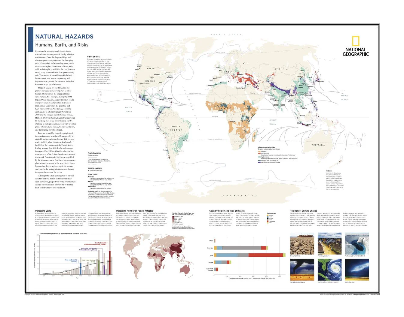
Global Thematic Wall Map | Disasters, Cities & Climate Risk | Atlas of the World (10th Edition) | Wall Format (711 × 559 mm)
A powerful global overview of risk in an increasingly vulnerable world, Natural Hazards: Humans, Earth, and Risks reveals how natural forces intersect with human populations and infrastructure. Published by National Geographic as part of the Atlas of the World, 10th Edition, this map brings together data, geography, and environmental science to highlight where—and why—hazards impact us most.
From earthquakes and storms to climate-driven events, it offers a clear and compelling perspective on the growing challenges facing modern societies.
Why This Map Stands Out
A global risk perspective
Explores natural hazards across continents and populations.
Data-rich and highly visual
Combines maps, charts, and graphics for clear interpretation.
Contemporary and relevant
Addresses rising disaster costs and climate-related impacts.
Part of a trusted atlas series
Drawn from National Geographic’s authoritative 10th Edition.
A thought-provoking wall map
Ideal for education, planning, and discussion.
🗺️ What the Map Shows
- Major cities at risk from natural hazards worldwide
- Increasing economic costs of disasters over time
- Growth in the number of people affected globally
- Breakdown of disaster impacts by region and hazard type
- The influence of climate change on hazard frequency and intensity
- A comprehensive framework linking environment, population, and risk
📐 Size & Format
711 mm (W) × 559 mm (H)
Landscape orientation
A versatile format ideal for:
- Classrooms and environmental science education
- Universities and research spaces
- Offices and policy environments
- Interiors focused on global challenges and sustainability
✨ Premium Finishes
| Format | Description |
|---|---|
| 📜 Paper (160 gsm) | Heavyweight matte-coated paper—ideal for framing. Preserves clarity in data and graphics. |
| 🧼 Laminated (Encapsulated) | Sealed in 2 × 80-micron gloss laminate. Durable, wipe-clean, and ideal for teaching use. |
| 🪵 Laminated + Timber Hang Rails | Laminated map mounted with lacquered natural timber rails and hanging cord—ready to display. |
| 🖼️ Canvas (395 gsm HP Professional Matte) | Printed with archival pigment inks. Enhances colour depth and presentation. |
| 🪵 Canvas + Timber Hang Rails | Canvas paired with timber rails for a refined, gallery-style presentation. |
🔨 Please allow up to 10 working days for professionally mounted hang-railed finishes.
📊 Specifications
| Feature | Detail |
|---|---|
| Title | Natural Hazards: Humans, Earth, and Risks |
| Publisher | National Geographic |
| Published | 2015 |
| Atlas | Atlas of the World, 10th Edition (Plate 10) |
| Dimensions | 711 mm × 559 mm |
| Orientation | Landscape |
| Map Type | Thematic |
| Coverage | Global |
| Collections | World, Thematic |
| Materials | 160 gsm matte paper / 2 × 80-micron laminate / 395 gsm HP Professional Matte Canvas |
| Printing | Pigment-based, fade-resistant inks |
| Origin | Printed in Australia |
🎯 Ideal For
- Students and educators of geography, environmental science, and risk studies
- Professionals in planning, emergency management, and policy
- Collectors of National Geographic thematic maps
- Interiors seeking a modern, data-driven display piece
- Gift buyers looking for a relevant and educational map
🌍 A World Under Pressure
Natural hazards are increasingly shaping our future:
- More people living in high-risk urban areas
- Rising financial costs from disasters
- Climate change amplifying extreme events
- A growing need for resilience and planning
This map captures those realities—offering a clear and compelling view of a world where human systems and natural forces are increasingly intertwined.
🤝 Our Commitment
- Printed in Australia using archival-quality production
- Faithfully reproduced to preserve clarity in data and graphics
- Premium materials selected for durability and longevity
- Each map is hand-checked before dispatch
- Carefully packaged for safe delivery
🚚 Delivery
- Paper, Laminated, Canvas (rolled): Dispatch within 1–2 business days
- Hang-Railed Maps: Made to order—allow up to 10 working days
- Packaging: Securely rolled in protective tubing
Understand the risks shaping our world—
a map that brings natural hazards and human vulnerability into sharp focus.
👉 Order now and add a powerful global perspective to your wall.
Original: $57.20
-65%$57.20
$20.02Product Information
Product Information
Shipping & Returns
Shipping & Returns
Description
Global Thematic Wall Map | Disasters, Cities & Climate Risk | Atlas of the World (10th Edition) | Wall Format (711 × 559 mm)
A powerful global overview of risk in an increasingly vulnerable world, Natural Hazards: Humans, Earth, and Risks reveals how natural forces intersect with human populations and infrastructure. Published by National Geographic as part of the Atlas of the World, 10th Edition, this map brings together data, geography, and environmental science to highlight where—and why—hazards impact us most.
From earthquakes and storms to climate-driven events, it offers a clear and compelling perspective on the growing challenges facing modern societies.
Why This Map Stands Out
A global risk perspective
Explores natural hazards across continents and populations.
Data-rich and highly visual
Combines maps, charts, and graphics for clear interpretation.
Contemporary and relevant
Addresses rising disaster costs and climate-related impacts.
Part of a trusted atlas series
Drawn from National Geographic’s authoritative 10th Edition.
A thought-provoking wall map
Ideal for education, planning, and discussion.
🗺️ What the Map Shows
- Major cities at risk from natural hazards worldwide
- Increasing economic costs of disasters over time
- Growth in the number of people affected globally
- Breakdown of disaster impacts by region and hazard type
- The influence of climate change on hazard frequency and intensity
- A comprehensive framework linking environment, population, and risk
📐 Size & Format
711 mm (W) × 559 mm (H)
Landscape orientation
A versatile format ideal for:
- Classrooms and environmental science education
- Universities and research spaces
- Offices and policy environments
- Interiors focused on global challenges and sustainability
✨ Premium Finishes
| Format | Description |
|---|---|
| 📜 Paper (160 gsm) | Heavyweight matte-coated paper—ideal for framing. Preserves clarity in data and graphics. |
| 🧼 Laminated (Encapsulated) | Sealed in 2 × 80-micron gloss laminate. Durable, wipe-clean, and ideal for teaching use. |
| 🪵 Laminated + Timber Hang Rails | Laminated map mounted with lacquered natural timber rails and hanging cord—ready to display. |
| 🖼️ Canvas (395 gsm HP Professional Matte) | Printed with archival pigment inks. Enhances colour depth and presentation. |
| 🪵 Canvas + Timber Hang Rails | Canvas paired with timber rails for a refined, gallery-style presentation. |
🔨 Please allow up to 10 working days for professionally mounted hang-railed finishes.
📊 Specifications
| Feature | Detail |
|---|---|
| Title | Natural Hazards: Humans, Earth, and Risks |
| Publisher | National Geographic |
| Published | 2015 |
| Atlas | Atlas of the World, 10th Edition (Plate 10) |
| Dimensions | 711 mm × 559 mm |
| Orientation | Landscape |
| Map Type | Thematic |
| Coverage | Global |
| Collections | World, Thematic |
| Materials | 160 gsm matte paper / 2 × 80-micron laminate / 395 gsm HP Professional Matte Canvas |
| Printing | Pigment-based, fade-resistant inks |
| Origin | Printed in Australia |
🎯 Ideal For
- Students and educators of geography, environmental science, and risk studies
- Professionals in planning, emergency management, and policy
- Collectors of National Geographic thematic maps
- Interiors seeking a modern, data-driven display piece
- Gift buyers looking for a relevant and educational map
🌍 A World Under Pressure
Natural hazards are increasingly shaping our future:
- More people living in high-risk urban areas
- Rising financial costs from disasters
- Climate change amplifying extreme events
- A growing need for resilience and planning
This map captures those realities—offering a clear and compelling view of a world where human systems and natural forces are increasingly intertwined.
🤝 Our Commitment
- Printed in Australia using archival-quality production
- Faithfully reproduced to preserve clarity in data and graphics
- Premium materials selected for durability and longevity
- Each map is hand-checked before dispatch
- Carefully packaged for safe delivery
🚚 Delivery
- Paper, Laminated, Canvas (rolled): Dispatch within 1–2 business days
- Hang-Railed Maps: Made to order—allow up to 10 working days
- Packaging: Securely rolled in protective tubing
Understand the risks shaping our world—
a map that brings natural hazards and human vulnerability into sharp focus.
👉 Order now and add a powerful global perspective to your wall.


