New England, United States - Atlas of the World, 11th Edition by National Geographic
Atlas of the World (11th Edition) | Physical & Political Wall Map | 798 × 610 mm | Premium Finishes
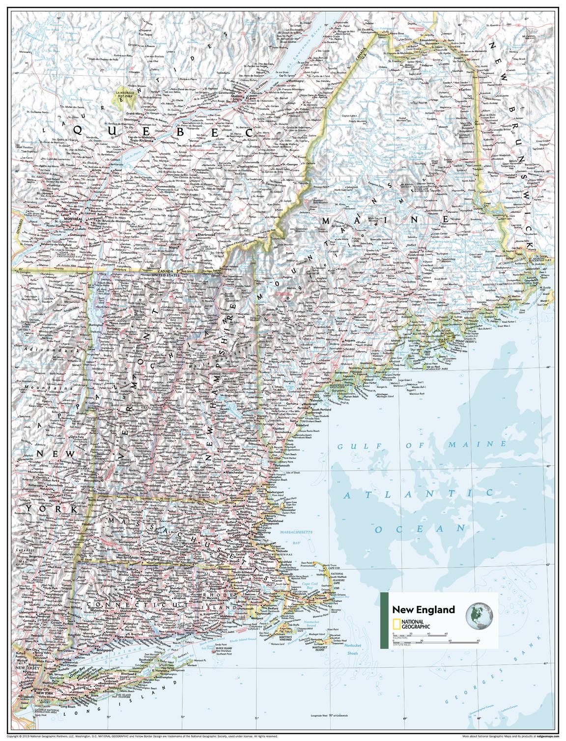
A refined and highly detailed view of one of America’s most historic regions, New England brings together physical landscapes and political boundaries in a beautifully balanced composition. Published by National Geographic as part of the Atlas of the World, 11th Edition, this map showcases the region with clarity, precision, and signature cartographic style.
From rugged coastlines to forested interiors, it offers a complete and engaging perspective on the northeastern United States.
Why This Map Stands Out
Atlas-quality cartography
Drawn from National Geographic’s authoritative 11th Edition.
Physical and political detail combined
Shows both terrain and administrative boundaries in one cohesive view.
Clear, accessible design
Carefully placed labels ensure readability across the entire map.
Educational and versatile
Ideal for geography, environmental studies, and general reference.
A compact yet impactful wall map
Designed to fit a wide range of spaces.
🗺️ What the Map Shows
- The New England region of the United States, including:
- Maine
- New Hampshire
- Vermont
- Massachusetts
- Rhode Island
- Connecticut
- Coastal features along the Atlantic Ocean, including bays and inlets
- Mountain ranges, forests, rivers, and lakes
- Cities, towns, and transport networks
- A clear depiction of how geography shapes settlement and movement
📐 Projection & Design
-
Projection: Albers Conic Equal-Area
- Minimises distortion between two standard parallels
- Preserves area relationships across the region
-
Style:
- Bright ocean tones and classic National Geographic palette
- Detailed shaded relief for terrain depth
- Clean typography for easy readability
📐 Size & Format
798 mm (H) × 610 mm (W)
Portrait orientation
A versatile format ideal for:
- Classrooms and teaching environments
- Offices and meeting spaces
- Home studies and libraries
- Compact wall displays with high visual impact
✨ Premium Finishes
| Format | Description |
|---|---|
| 📜 Paper (160 gsm) | Heavyweight matte-coated paper—ideal for framing. Preserves fine cartographic detail. |
| 🧼 Laminated (Encapsulated) | Sealed in 2 × 80-micron gloss laminate. Durable, wipe-clean, and suitable for teaching use. |
| 🪵 Laminated + Timber Hang Rails | Laminated map mounted with lacquered natural timber rails and hanging cord—ready to display. |
| 🖼️ Canvas (395 gsm HP Professional Matte) | Printed with archival pigment inks. Enhances colour depth and presentation. |
| 🪵 Canvas + Timber Hang Rails | Canvas paired with timber rails for a refined, gallery-style finish. |
🔨 Please allow up to 10 working days for professionally mounted hang-railed finishes.
📊 Specifications
| Feature | Detail |
|---|---|
| Title | New England |
| Publisher | National Geographic |
| Published | 2019 |
| Atlas | Atlas of the World, 11th Edition (Plate 44) |
| Scale | 1:1,053,000 |
| Dimensions | 798 mm × 610 mm |
| Orientation | Portrait |
| Projection | Albers Conic Equal-Area |
| Map Type | Political / Physical |
| Coverage | New England, USA |
| Collections | USA, Political, Regional |
| Materials | 160 gsm matte paper / 2 × 80-micron laminate / 395 gsm HP Professional Matte Canvas |
| Printing | Pigment-based, fade-resistant inks |
| Origin | Printed in Australia |
🎯 Ideal For
- Students and educators of U.S. geography and regional studies
- Those interested in New England’s landscapes and history
- Collectors of National Geographic atlas maps
- Interiors seeking a clean, informative wall display
- Gift buyers looking for a practical and elegant map
🌲 A Region of Character and Contrast
New England is defined by:
- Rocky coastlines and maritime heritage
- Forested hills and mountain ranges
- Historic towns and modern cities
- Landscapes shaped by both nature and settlement
This map captures that identity—offering a clear and engaging view of a region where history, geography, and community are closely connected.
🤝 Our Commitment
- Printed in Australia using archival-quality production
- Faithfully reproduced to preserve colour, clarity, and detail
- Premium materials selected for durability and longevity
- Each map is hand-checked before dispatch
- Carefully packaged for safe delivery
🚚 Delivery
- Paper, Laminated, Canvas (rolled): Dispatch within 1–2 business days
- Hang-Railed Maps: Made to order—allow up to 10 working days
- Packaging: Securely rolled in protective tubing
Discover the detail of New England—
a map that brings landscape, history, and place into sharp focus.
👉 Order now and add a refined regional map to your wall.
Original: $57.20
-65%$57.20
$20.02Product Information
Product Information
Shipping & Returns
Shipping & Returns
Description
Atlas of the World (11th Edition) | Physical & Political Wall Map | 798 × 610 mm | Premium Finishes
A refined and highly detailed view of one of America’s most historic regions, New England brings together physical landscapes and political boundaries in a beautifully balanced composition. Published by National Geographic as part of the Atlas of the World, 11th Edition, this map showcases the region with clarity, precision, and signature cartographic style.
From rugged coastlines to forested interiors, it offers a complete and engaging perspective on the northeastern United States.
Why This Map Stands Out
Atlas-quality cartography
Drawn from National Geographic’s authoritative 11th Edition.
Physical and political detail combined
Shows both terrain and administrative boundaries in one cohesive view.
Clear, accessible design
Carefully placed labels ensure readability across the entire map.
Educational and versatile
Ideal for geography, environmental studies, and general reference.
A compact yet impactful wall map
Designed to fit a wide range of spaces.
🗺️ What the Map Shows
- The New England region of the United States, including:
- Maine
- New Hampshire
- Vermont
- Massachusetts
- Rhode Island
- Connecticut
- Coastal features along the Atlantic Ocean, including bays and inlets
- Mountain ranges, forests, rivers, and lakes
- Cities, towns, and transport networks
- A clear depiction of how geography shapes settlement and movement
📐 Projection & Design
-
Projection: Albers Conic Equal-Area
- Minimises distortion between two standard parallels
- Preserves area relationships across the region
-
Style:
- Bright ocean tones and classic National Geographic palette
- Detailed shaded relief for terrain depth
- Clean typography for easy readability
📐 Size & Format
798 mm (H) × 610 mm (W)
Portrait orientation
A versatile format ideal for:
- Classrooms and teaching environments
- Offices and meeting spaces
- Home studies and libraries
- Compact wall displays with high visual impact
✨ Premium Finishes
| Format | Description |
|---|---|
| 📜 Paper (160 gsm) | Heavyweight matte-coated paper—ideal for framing. Preserves fine cartographic detail. |
| 🧼 Laminated (Encapsulated) | Sealed in 2 × 80-micron gloss laminate. Durable, wipe-clean, and suitable for teaching use. |
| 🪵 Laminated + Timber Hang Rails | Laminated map mounted with lacquered natural timber rails and hanging cord—ready to display. |
| 🖼️ Canvas (395 gsm HP Professional Matte) | Printed with archival pigment inks. Enhances colour depth and presentation. |
| 🪵 Canvas + Timber Hang Rails | Canvas paired with timber rails for a refined, gallery-style finish. |
🔨 Please allow up to 10 working days for professionally mounted hang-railed finishes.
📊 Specifications
| Feature | Detail |
|---|---|
| Title | New England |
| Publisher | National Geographic |
| Published | 2019 |
| Atlas | Atlas of the World, 11th Edition (Plate 44) |
| Scale | 1:1,053,000 |
| Dimensions | 798 mm × 610 mm |
| Orientation | Portrait |
| Projection | Albers Conic Equal-Area |
| Map Type | Political / Physical |
| Coverage | New England, USA |
| Collections | USA, Political, Regional |
| Materials | 160 gsm matte paper / 2 × 80-micron laminate / 395 gsm HP Professional Matte Canvas |
| Printing | Pigment-based, fade-resistant inks |
| Origin | Printed in Australia |
🎯 Ideal For
- Students and educators of U.S. geography and regional studies
- Those interested in New England’s landscapes and history
- Collectors of National Geographic atlas maps
- Interiors seeking a clean, informative wall display
- Gift buyers looking for a practical and elegant map
🌲 A Region of Character and Contrast
New England is defined by:
- Rocky coastlines and maritime heritage
- Forested hills and mountain ranges
- Historic towns and modern cities
- Landscapes shaped by both nature and settlement
This map captures that identity—offering a clear and engaging view of a region where history, geography, and community are closely connected.
🤝 Our Commitment
- Printed in Australia using archival-quality production
- Faithfully reproduced to preserve colour, clarity, and detail
- Premium materials selected for durability and longevity
- Each map is hand-checked before dispatch
- Carefully packaged for safe delivery
🚚 Delivery
- Paper, Laminated, Canvas (rolled): Dispatch within 1–2 business days
- Hang-Railed Maps: Made to order—allow up to 10 working days
- Packaging: Securely rolled in protective tubing
Discover the detail of New England—
a map that brings landscape, history, and place into sharp focus.
👉 Order now and add a refined regional map to your wall.


