New York City - Published 1990 by National Geographic
Special Places of the World Series | Urban, Cultural & Demographic Map | Wall Format (791 × 253 mm) | Premium Finishes
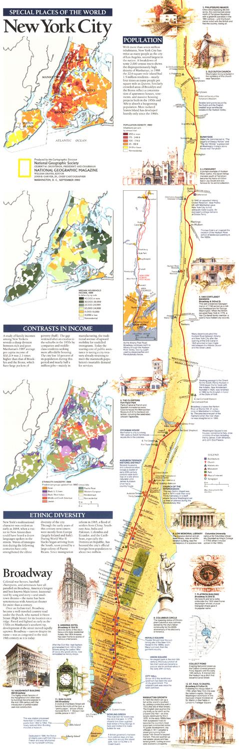
A fascinating portrait of one of the world’s great cities, New York City reveals the layers of population, culture, and economic life that define this global metropolis. Published by National Geographic in September 1990 as part of the Special Places of the World series, this map blends cartography with social insight—offering a deeper understanding of New York City.
More than a map, it is a visual study of urban life, capturing the diversity and complexity that make the city unique.
Why This Map Stands Out
A city beyond geography
Explores New York through demographics, culture, and economics.
Part of the Special Places series
Combines storytelling with detailed cartographic presentation.
Data-rich and insightful
Includes multiple maps and notes highlighting key urban patterns.
Compact and distinctive format
A tall, narrow layout ideal for display.
A unique urban study
Perfect for those interested in cities and how they function.
🗺️ What the Map Shows
- The structure and layout of New York City
- Thematic maps highlighting:
- Population density across boroughs
- Ethnic diversity and cultural distribution
- Income patterns and economic variation
- Supporting notes and explanatory text providing context
- A broader understanding of the city as a living, evolving system
📐 Size & Format
791 mm (H) × 253 mm (W)
Portrait orientation (narrow format)
A distinctive size ideal for:
- Framed vertical displays
- Home offices and studies
- Libraries and urban-themed interiors
- Pairing with its companion Manhattan map
✨ Premium Finishes
| Format | Description |
|---|---|
| 📜 Paper (160 gsm) | Heavyweight matte-coated paper—ideal for framing. Preserves clarity in text and graphics. |
| 🧼 Laminated (Encapsulated) | Sealed in 2 × 80-micron gloss laminate. Durable and suitable for reference use. |
| 🪵 Laminated + Timber Hang Rails | Laminated map mounted with lacquered natural timber rails and hanging cord—ready to display. |
| 🖼️ Canvas (395 gsm HP Professional Matte) | Printed with archival pigment inks. Enhances depth and presentation. |
| 🪵 Canvas + Timber Hang Rails | Canvas paired with timber rails for a refined, gallery-style finish. |
🔨 Please allow up to 10 working days for professionally mounted hang-railed finishes.
📊 Specifications
| Feature | Detail |
|---|---|
| Title | New York City |
| Publisher | National Geographic |
| Published | 1990 |
| Series | Special Places of the World |
| Dimensions | 791 mm × 253 mm |
| Orientation | Portrait (narrow) |
| Map Type | Historical / City / Thematic |
| Coverage | New York City, USA |
| Collections | USA, Historical, City |
| Materials | 160 gsm matte paper / 2 × 80-micron laminate / 395 gsm HP Professional Matte Canvas |
| Printing | Pigment-based, fade-resistant inks |
| Origin | Printed in Australia |
🎯 Ideal For
- Students and educators of urban studies and geography
- Those interested in demographics and city dynamics
- Collectors of National Geographic city maps
- Interiors seeking a distinctive, vertical display piece
- Gift buyers looking for a unique and insightful map
🏙️ A City in Layers
New York City is more than streets and landmarks:
- A dense and dynamic population
- A mosaic of cultures and communities
- Economic contrasts shaping daily life
- A city constantly evolving and redefining itself
This map captures that complexity—offering a clear and compelling view of a city where data, diversity, and density define the experience.
🤝 Our Commitment
- Printed in Australia using archival-quality production
- Faithfully reproduced to preserve clarity in text and graphics
- Premium materials selected for durability and longevity
- Each map is hand-checked before dispatch
- Carefully packaged for safe delivery
🚚 Delivery
- Paper, Laminated, Canvas (rolled): Dispatch within 1–2 business days
- Hang-Railed Maps: Made to order—allow up to 10 working days
- Packaging: Securely rolled in protective tubing
Explore the city beyond the skyline—
a map that reveals New York’s people, patterns, and pulse.
👉 Order now and add a unique urban perspective to your wall.
Product Information
Product Information
Shipping & Returns
Shipping & Returns
Description
Special Places of the World Series | Urban, Cultural & Demographic Map | Wall Format (791 × 253 mm) | Premium Finishes
A fascinating portrait of one of the world’s great cities, New York City reveals the layers of population, culture, and economic life that define this global metropolis. Published by National Geographic in September 1990 as part of the Special Places of the World series, this map blends cartography with social insight—offering a deeper understanding of New York City.
More than a map, it is a visual study of urban life, capturing the diversity and complexity that make the city unique.
Why This Map Stands Out
A city beyond geography
Explores New York through demographics, culture, and economics.
Part of the Special Places series
Combines storytelling with detailed cartographic presentation.
Data-rich and insightful
Includes multiple maps and notes highlighting key urban patterns.
Compact and distinctive format
A tall, narrow layout ideal for display.
A unique urban study
Perfect for those interested in cities and how they function.
🗺️ What the Map Shows
- The structure and layout of New York City
- Thematic maps highlighting:
- Population density across boroughs
- Ethnic diversity and cultural distribution
- Income patterns and economic variation
- Supporting notes and explanatory text providing context
- A broader understanding of the city as a living, evolving system
📐 Size & Format
791 mm (H) × 253 mm (W)
Portrait orientation (narrow format)
A distinctive size ideal for:
- Framed vertical displays
- Home offices and studies
- Libraries and urban-themed interiors
- Pairing with its companion Manhattan map
✨ Premium Finishes
| Format | Description |
|---|---|
| 📜 Paper (160 gsm) | Heavyweight matte-coated paper—ideal for framing. Preserves clarity in text and graphics. |
| 🧼 Laminated (Encapsulated) | Sealed in 2 × 80-micron gloss laminate. Durable and suitable for reference use. |
| 🪵 Laminated + Timber Hang Rails | Laminated map mounted with lacquered natural timber rails and hanging cord—ready to display. |
| 🖼️ Canvas (395 gsm HP Professional Matte) | Printed with archival pigment inks. Enhances depth and presentation. |
| 🪵 Canvas + Timber Hang Rails | Canvas paired with timber rails for a refined, gallery-style finish. |
🔨 Please allow up to 10 working days for professionally mounted hang-railed finishes.
📊 Specifications
| Feature | Detail |
|---|---|
| Title | New York City |
| Publisher | National Geographic |
| Published | 1990 |
| Series | Special Places of the World |
| Dimensions | 791 mm × 253 mm |
| Orientation | Portrait (narrow) |
| Map Type | Historical / City / Thematic |
| Coverage | New York City, USA |
| Collections | USA, Historical, City |
| Materials | 160 gsm matte paper / 2 × 80-micron laminate / 395 gsm HP Professional Matte Canvas |
| Printing | Pigment-based, fade-resistant inks |
| Origin | Printed in Australia |
🎯 Ideal For
- Students and educators of urban studies and geography
- Those interested in demographics and city dynamics
- Collectors of National Geographic city maps
- Interiors seeking a distinctive, vertical display piece
- Gift buyers looking for a unique and insightful map
🏙️ A City in Layers
New York City is more than streets and landmarks:
- A dense and dynamic population
- A mosaic of cultures and communities
- Economic contrasts shaping daily life
- A city constantly evolving and redefining itself
This map captures that complexity—offering a clear and compelling view of a city where data, diversity, and density define the experience.
🤝 Our Commitment
- Printed in Australia using archival-quality production
- Faithfully reproduced to preserve clarity in text and graphics
- Premium materials selected for durability and longevity
- Each map is hand-checked before dispatch
- Carefully packaged for safe delivery
🚚 Delivery
- Paper, Laminated, Canvas (rolled): Dispatch within 1–2 business days
- Hang-Railed Maps: Made to order—allow up to 10 working days
- Packaging: Securely rolled in protective tubing
Explore the city beyond the skyline—
a map that reveals New York’s people, patterns, and pulse.
👉 Order now and add a unique urban perspective to your wall.


