New York State Wall Map by National Geographic
Physical Wall Map | Mountains, Lakes & Infrastructure | Large Format (1029 × 768 mm) | Premium Finishes
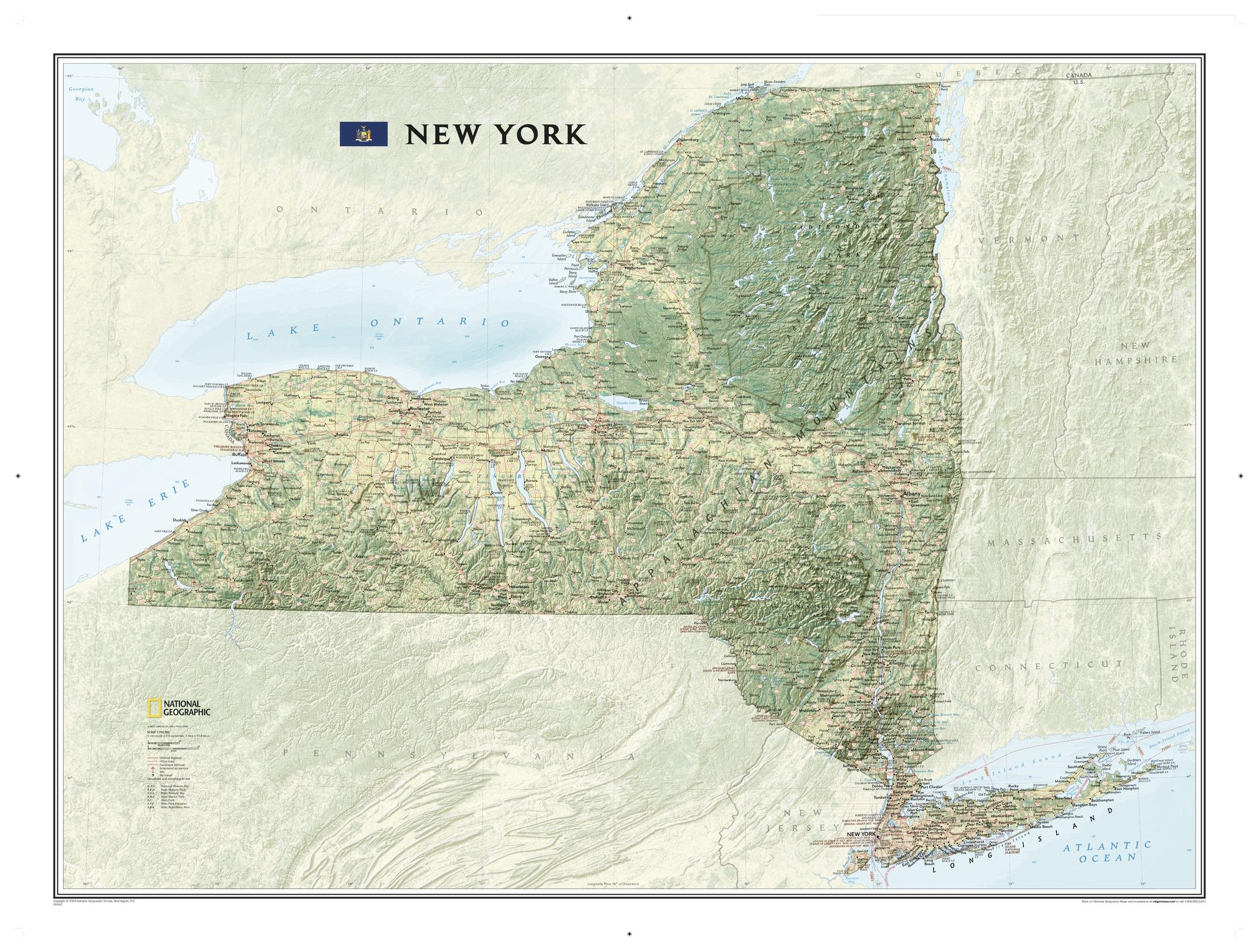
A beautifully rendered portrait of one of America’s most diverse states, New York State brings landscape and infrastructure together in exceptional detail. Published by National Geographic, this map uses rich colour and shaded relief to reveal the terrain—from mountain ranges and forests to valleys and waterways—across New York.
Designed for both reference and display, it offers a complete view of the state’s geography, transport networks, and recreational highlights.
Why This Map Stands Out
Striking physical detail
Shaded relief highlights mountains, valleys, forests, and waterways.
Comprehensive statewide coverage
Captures both natural features and built infrastructure.
Highly readable cartography
Hundreds of place names clearly positioned for easy reference.
Outdoor and recreation insight
Includes ski areas, parks, and major trails.
A large-format statement piece
Ideal for study, planning, or display.
🗺️ What the Map Shows
- The full extent of New York State, including:
- Mountain ranges such as the Adirondacks and Catskills
- Forests, valleys, and varied terrain
- Major natural features:
- Lakes, rivers, and reservoirs
- Prominent peaks and elevation zones
- Cities, towns, and transport networks:
- Highways, railways, and airports
- National and state parks across the region
- Recreational features including ski resorts
- The route of the Appalachian National Scenic Trail as it passes through the state
📐 Size & Format
1029 mm (H) × 768 mm (W)
Portrait orientation
A large, high-impact format ideal for:
- Classrooms and geography education
- Offices and planning environments
- Home studies and feature walls
- Outdoor and travel enthusiasts
✨ Premium Finishes
| Format | Description |
|---|---|
| 📜 Paper (160 gsm) | Heavyweight matte-coated paper—ideal for framing. Preserves fine terrain detail. |
| 🧼 Laminated (Encapsulated) | Sealed in 2 × 80-micron gloss laminate. Durable, wipe-clean, and ideal for frequent reference. |
| 🪵 Laminated + Timber Hang Rails | Laminated map mounted with lacquered natural timber rails and hanging cord—ready to display. |
| 🖼️ Canvas (395 gsm HP Professional Matte) | Printed with archival pigment inks. Enhances depth and colour richness. |
| 🪵 Canvas + Timber Hang Rails | Canvas paired with timber rails for a refined, gallery-style presentation. |
🔨 Please allow up to 10 working days for professionally mounted hang-railed finishes.
📊 Specifications
| Feature | Detail |
|---|---|
| Title | New York State |
| Publisher | National Geographic |
| Published | 2009 |
| Scale | 1:750,000 |
| Dimensions | 1029 mm × 768 mm |
| Orientation | Portrait |
| Map Type | Physical |
| Coverage | New York State, USA |
| Collections | USA, Physical |
| Materials | 160 gsm matte paper / 2 × 80-micron laminate / 395 gsm HP Professional Matte Canvas |
| Printing | Pigment-based, fade-resistant inks |
| Origin | Printed in Australia |
🎯 Ideal For
- Students and educators of U.S. geography and physical landscapes
- Outdoor enthusiasts exploring New York’s mountains and trails
- Collectors of National Geographic wall maps
- Interiors seeking a bold, landscape-driven display piece
- Gift buyers looking for a practical and visually striking map
🌄 A State of Natural Diversity
New York State is defined by contrast:
- Mountain wilderness in the north
- Rolling hills and forests across the interior
- Major waterways shaping settlement and travel
- A blend of natural beauty and modern infrastructure
This map captures that diversity—offering a clear and compelling view of a state where landscape and life are closely connected.
🤝 Our Commitment
- Printed in Australia using archival-quality production
- Faithfully reproduced to preserve colour, clarity, and detail
- Premium materials selected for durability and longevity
- Each map is hand-checked before dispatch
- Carefully packaged for safe delivery
🚚 Delivery
- Paper, Laminated, Canvas (rolled): Dispatch within 1–2 business days
- Hang-Railed Maps: Made to order—allow up to 10 working days
- Packaging: Securely rolled in protective tubing
Explore New York in exceptional detail—
a map that brings the Empire State into sharp geographic focus.
👉 Order now and add a striking regional map to your wall.
Product Information
Product Information
Shipping & Returns
Shipping & Returns
Description
Physical Wall Map | Mountains, Lakes & Infrastructure | Large Format (1029 × 768 mm) | Premium Finishes
A beautifully rendered portrait of one of America’s most diverse states, New York State brings landscape and infrastructure together in exceptional detail. Published by National Geographic, this map uses rich colour and shaded relief to reveal the terrain—from mountain ranges and forests to valleys and waterways—across New York.
Designed for both reference and display, it offers a complete view of the state’s geography, transport networks, and recreational highlights.
Why This Map Stands Out
Striking physical detail
Shaded relief highlights mountains, valleys, forests, and waterways.
Comprehensive statewide coverage
Captures both natural features and built infrastructure.
Highly readable cartography
Hundreds of place names clearly positioned for easy reference.
Outdoor and recreation insight
Includes ski areas, parks, and major trails.
A large-format statement piece
Ideal for study, planning, or display.
🗺️ What the Map Shows
- The full extent of New York State, including:
- Mountain ranges such as the Adirondacks and Catskills
- Forests, valleys, and varied terrain
- Major natural features:
- Lakes, rivers, and reservoirs
- Prominent peaks and elevation zones
- Cities, towns, and transport networks:
- Highways, railways, and airports
- National and state parks across the region
- Recreational features including ski resorts
- The route of the Appalachian National Scenic Trail as it passes through the state
📐 Size & Format
1029 mm (H) × 768 mm (W)
Portrait orientation
A large, high-impact format ideal for:
- Classrooms and geography education
- Offices and planning environments
- Home studies and feature walls
- Outdoor and travel enthusiasts
✨ Premium Finishes
| Format | Description |
|---|---|
| 📜 Paper (160 gsm) | Heavyweight matte-coated paper—ideal for framing. Preserves fine terrain detail. |
| 🧼 Laminated (Encapsulated) | Sealed in 2 × 80-micron gloss laminate. Durable, wipe-clean, and ideal for frequent reference. |
| 🪵 Laminated + Timber Hang Rails | Laminated map mounted with lacquered natural timber rails and hanging cord—ready to display. |
| 🖼️ Canvas (395 gsm HP Professional Matte) | Printed with archival pigment inks. Enhances depth and colour richness. |
| 🪵 Canvas + Timber Hang Rails | Canvas paired with timber rails for a refined, gallery-style presentation. |
🔨 Please allow up to 10 working days for professionally mounted hang-railed finishes.
📊 Specifications
| Feature | Detail |
|---|---|
| Title | New York State |
| Publisher | National Geographic |
| Published | 2009 |
| Scale | 1:750,000 |
| Dimensions | 1029 mm × 768 mm |
| Orientation | Portrait |
| Map Type | Physical |
| Coverage | New York State, USA |
| Collections | USA, Physical |
| Materials | 160 gsm matte paper / 2 × 80-micron laminate / 395 gsm HP Professional Matte Canvas |
| Printing | Pigment-based, fade-resistant inks |
| Origin | Printed in Australia |
🎯 Ideal For
- Students and educators of U.S. geography and physical landscapes
- Outdoor enthusiasts exploring New York’s mountains and trails
- Collectors of National Geographic wall maps
- Interiors seeking a bold, landscape-driven display piece
- Gift buyers looking for a practical and visually striking map
🌄 A State of Natural Diversity
New York State is defined by contrast:
- Mountain wilderness in the north
- Rolling hills and forests across the interior
- Major waterways shaping settlement and travel
- A blend of natural beauty and modern infrastructure
This map captures that diversity—offering a clear and compelling view of a state where landscape and life are closely connected.
🤝 Our Commitment
- Printed in Australia using archival-quality production
- Faithfully reproduced to preserve colour, clarity, and detail
- Premium materials selected for durability and longevity
- Each map is hand-checked before dispatch
- Carefully packaged for safe delivery
🚚 Delivery
- Paper, Laminated, Canvas (rolled): Dispatch within 1–2 business days
- Hang-Railed Maps: Made to order—allow up to 10 working days
- Packaging: Securely rolled in protective tubing
Explore New York in exceptional detail—
a map that brings the Empire State into sharp geographic focus.
👉 Order now and add a striking regional map to your wall.


