New Zealand National Geographic Folded Map
🇳🇿 New Zealand — National Geographic Adventure Map
Waterproof • Tear-Resistant • Double-Sided • Adventure-Ready Cartography
🌏 Discover the Land of the Long White Cloud
From geothermal valleys and volcanic plateaus in the North Island to the glacier-carved fjords and alpine passes of the South Island, this National Geographic Adventure Map captures every curve of Aotearoa / New Zealand in spectacular detail.
Built for explorers, it’s printed on waterproof, tear-resistant synthetic paper—ready for misty fjords, mountain trails, and coastal drives where digital navigation might fade away. Whether you’re planning the trip of a lifetime or mapping memories from past adventures, this map brings New Zealand’s beauty to your fingertips.
🗺 Comprehensive National Coverage
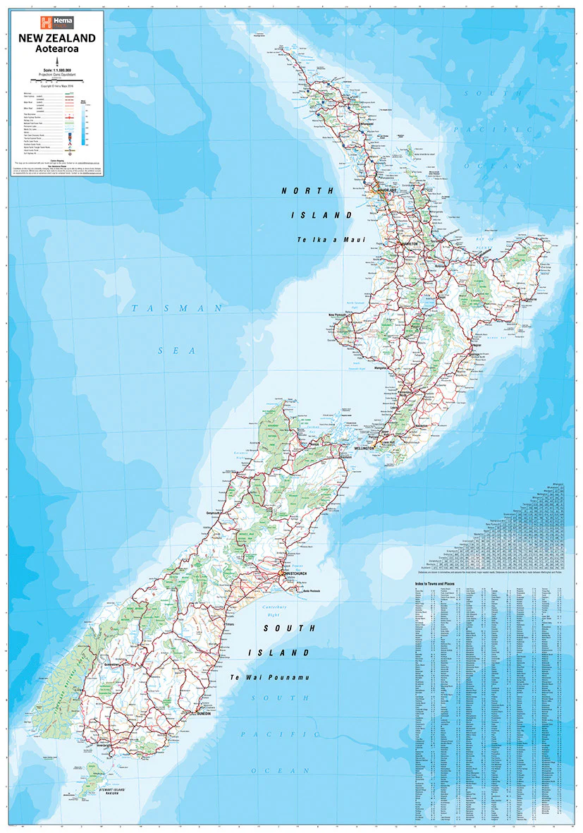
Side 1 – North Island
-
Complete coverage from Cape Reinga to Wellington.
-
Includes Auckland, Rotorua, Wellington, Egmont National Park, Hauraki Gulf Maritime Park, and Te Urewera National Park.
-
Highlights geothermal areas, national parks, hot springs, and key cultural sites.
-
Ideal for planning road trips through volcanic heartlands and coastal sanctuaries.
Side 2 – South Island
-
From Marlborough Sounds and Christchurch to Fiordland National Park and Stewart Island.
-
All major highways and secondary routes clearly marked, including ferry links between islands.
-
Topographic relief reveals the dramatic rise of the Southern Alps and glacial valleys.
-
Includes campgrounds, viewpoints, and protected wilderness areas.
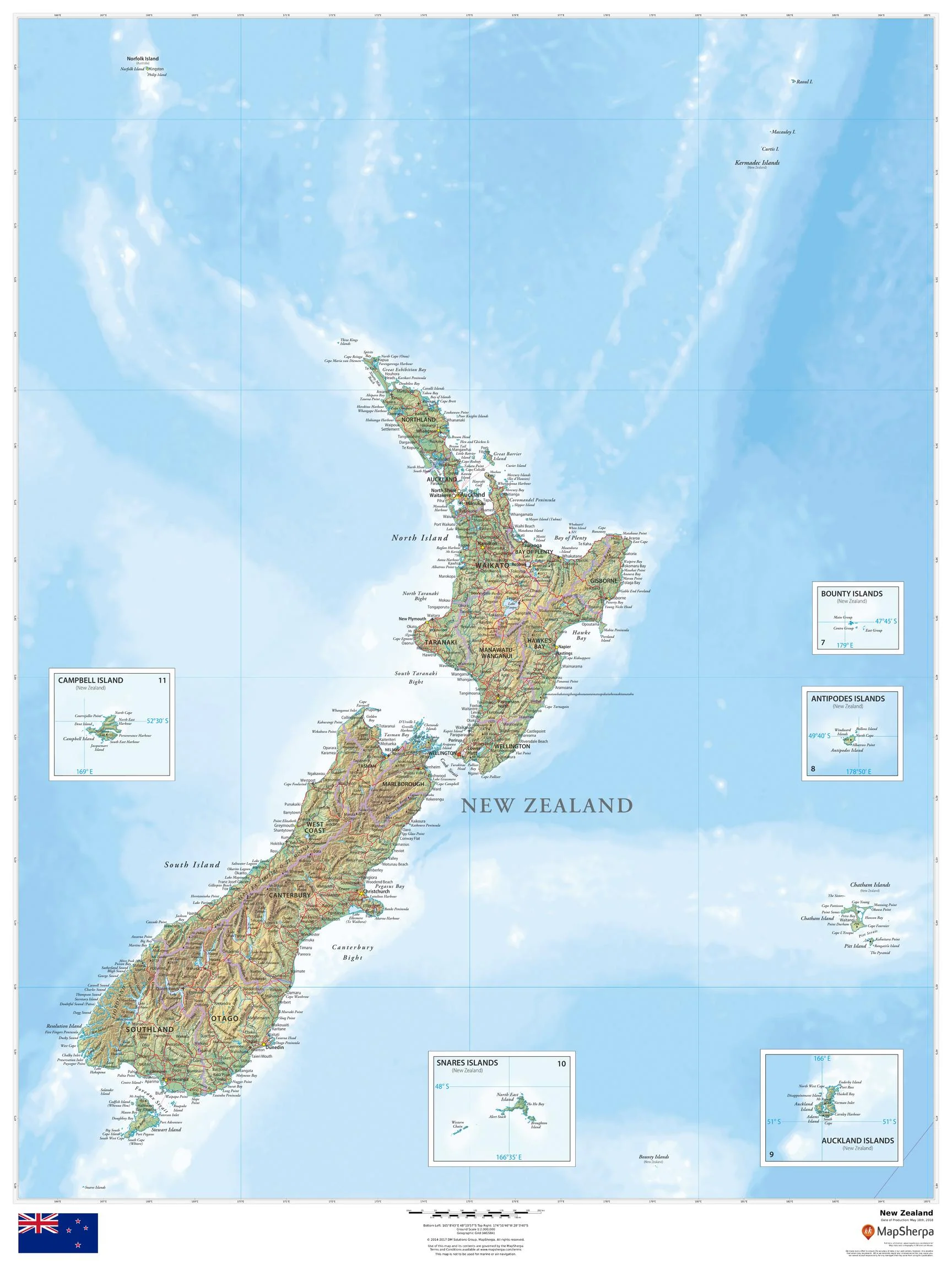
Inset Maps
-
Extended coverage of outlying islands: Chatham, Campbell, Antipodes, Kermadec, and Auckland Islands, ensuring the entire realm of New Zealand is included.
🧭 Key Features & Highlights
-
Scale 1 : 1,100,000 (approx.) — ideal balance of overview and road detail.
-
Road networks: motorways, highways, secondary routes, scenic byways.
-
Points of interest: campgrounds, waterfalls, geothermal areas, hiking tracks, national parks, and cultural landmarks.
-
City & town index for quick reference.
-
Elevation shading to visualise terrain and mountain ranges.
-
National parks & marine reserves clearly outlined.
-
Durable construction — fold, refold, and use in all weather without tearing.
🚐 Ideal For
-
Road-trippers exploring New Zealand’s scenic highways.
-
Backpackers & campers seeking adventure off the beaten path.
-
Hikers & trekkers tackling famous trails like Tongariro Crossing or Routeburn Track.
-
Photographers & naturalists chasing light, wildlife, and landscapes.
-
Educators & students learning about New Zealand’s diverse geography.
-
Collectors of National Geographic’s globally respected cartography.
📐 Specifications
| Feature | Detail |
|---|---|
| Publisher | National Geographic Maps |
| Series | Adventure Map |
| Regions Covered | North & South Islands + Outlying Islands |
| Scale | 1 : 1,100,000 (approx.) |
| Map Type | Folded, double-sided |
| Flat Size | 950 mm × 650 mm |
| Material | Waterproof, tear-resistant synthetic paper |
| Inks | Fade-resistant pigment inks |
| ISBN | 9781566955267 |
🏕 Why Travellers Choose This Map
-
National Geographic accuracy — trusted by adventurers worldwide.
-
Adventure-grade durability — survives rain, creases, and rough backpacks.
-
Complete national coverage — both islands, all major regions, and distant outposts.
-
Beautiful design — suitable for planning, reference, or framing after your journey.
✨ Explore, Dream, Discover
Whether you’re winding along the Milford Road, tracing the Thermal Explorer Highway, or venturing to the subantarctic islands, the 🇳🇿 National Geographic New Zealand Adventure Map is the durable, detail-rich guide that will keep you oriented—no matter how far you roam.
Original: $20.71
-65%$20.71
$7.25Product Information
Product Information
Shipping & Returns
Shipping & Returns
Description
🇳🇿 New Zealand — National Geographic Adventure Map
Waterproof • Tear-Resistant • Double-Sided • Adventure-Ready Cartography
🌏 Discover the Land of the Long White Cloud
From geothermal valleys and volcanic plateaus in the North Island to the glacier-carved fjords and alpine passes of the South Island, this National Geographic Adventure Map captures every curve of Aotearoa / New Zealand in spectacular detail.
Built for explorers, it’s printed on waterproof, tear-resistant synthetic paper—ready for misty fjords, mountain trails, and coastal drives where digital navigation might fade away. Whether you’re planning the trip of a lifetime or mapping memories from past adventures, this map brings New Zealand’s beauty to your fingertips.
🗺 Comprehensive National Coverage
Side 1 – North Island
-
Complete coverage from Cape Reinga to Wellington.
-
Includes Auckland, Rotorua, Wellington, Egmont National Park, Hauraki Gulf Maritime Park, and Te Urewera National Park.
-
Highlights geothermal areas, national parks, hot springs, and key cultural sites.
-
Ideal for planning road trips through volcanic heartlands and coastal sanctuaries.
Side 2 – South Island
-
From Marlborough Sounds and Christchurch to Fiordland National Park and Stewart Island.
-
All major highways and secondary routes clearly marked, including ferry links between islands.
-
Topographic relief reveals the dramatic rise of the Southern Alps and glacial valleys.
-
Includes campgrounds, viewpoints, and protected wilderness areas.
Inset Maps
-
Extended coverage of outlying islands: Chatham, Campbell, Antipodes, Kermadec, and Auckland Islands, ensuring the entire realm of New Zealand is included.
🧭 Key Features & Highlights
-
Scale 1 : 1,100,000 (approx.) — ideal balance of overview and road detail.
-
Road networks: motorways, highways, secondary routes, scenic byways.
-
Points of interest: campgrounds, waterfalls, geothermal areas, hiking tracks, national parks, and cultural landmarks.
-
City & town index for quick reference.
-
Elevation shading to visualise terrain and mountain ranges.
-
National parks & marine reserves clearly outlined.
-
Durable construction — fold, refold, and use in all weather without tearing.
🚐 Ideal For
-
Road-trippers exploring New Zealand’s scenic highways.
-
Backpackers & campers seeking adventure off the beaten path.
-
Hikers & trekkers tackling famous trails like Tongariro Crossing or Routeburn Track.
-
Photographers & naturalists chasing light, wildlife, and landscapes.
-
Educators & students learning about New Zealand’s diverse geography.
-
Collectors of National Geographic’s globally respected cartography.
📐 Specifications
| Feature | Detail |
|---|---|
| Publisher | National Geographic Maps |
| Series | Adventure Map |
| Regions Covered | North & South Islands + Outlying Islands |
| Scale | 1 : 1,100,000 (approx.) |
| Map Type | Folded, double-sided |
| Flat Size | 950 mm × 650 mm |
| Material | Waterproof, tear-resistant synthetic paper |
| Inks | Fade-resistant pigment inks |
| ISBN | 9781566955267 |
🏕 Why Travellers Choose This Map
-
National Geographic accuracy — trusted by adventurers worldwide.
-
Adventure-grade durability — survives rain, creases, and rough backpacks.
-
Complete national coverage — both islands, all major regions, and distant outposts.
-
Beautiful design — suitable for planning, reference, or framing after your journey.
✨ Explore, Dream, Discover
Whether you’re winding along the Milford Road, tracing the Thermal Explorer Highway, or venturing to the subantarctic islands, the 🇳🇿 National Geographic New Zealand Adventure Map is the durable, detail-rich guide that will keep you oriented—no matter how far you roam.