New Zealand, New Guinea and the Principal Pacific Islands - Published 1962 by National Geographic
New Zealand, New Guinea and the Principal Pacific Islands - Published 1962 by National Geographic
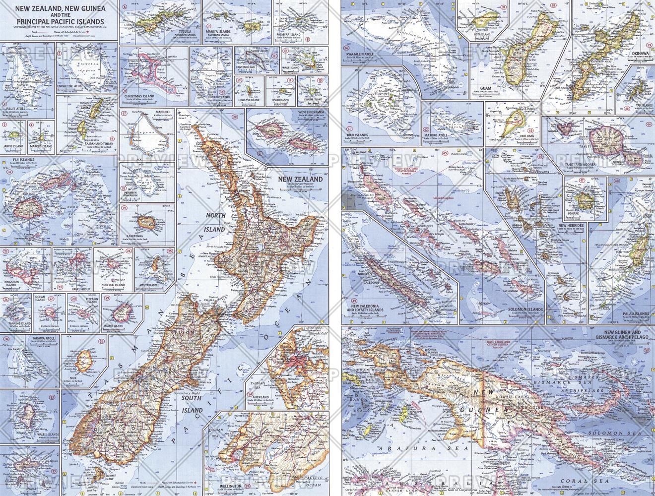
Historical Pacific Wall Map | Oceania, Island Groups & Ocean Context | Wall Format (633 × 480 mm) | Premium Finishes
A beautifully composed mid-century map of the Pacific world, New Zealand, New Guinea & the Principal Pacific Islands captures the vast oceanic expanse and its scattered island nations with clarity and elegance. Published by National Geographic in April 1962, this work reflects a time when the Pacific was being understood as both a geographic and cultural network.
From the shores of Australia to the far-reaching islands of Oceania, it presents a sweeping view of a region defined by distance, diversity, and connection.
Why This Map Stands Out
A classic Pacific perspective
Captures the scale and complexity of the world’s largest ocean.
Mid-century National Geographic style
Clean cartography with balanced colour and clarity.
Regional and oceanic context combined
Shows both island groups and bordering continental coastlines.
Inset-rich detail
Highlights key island groups for closer inspection.
A refined historical wall map
Ideal for collectors and Pacific enthusiasts.
🗺️ What the Map Shows
- The broader Pacific region, including:
- New Zealand
- New Guinea
- Major island groups across Oceania
- The surrounding continental coastlines bordering the Pacific Ocean
- Key island chains and archipelagos
- Inset maps providing detailed views of larger island groups
- A regional framework linking ocean, islands, and continents
📐 Size & Format
633 mm (W) × 480 mm (H)
Landscape orientation
A compact, display-friendly format ideal for:
- Home offices and studies
- Libraries and map collections
- Coastal and travel-inspired interiors
- Educational settings focused on geography
✨ Premium Finishes
| Format | Description |
|---|---|
| 📜 Paper (160 gsm) | Heavyweight matte-coated paper—ideal for framing. Preserves fine cartographic detail. |
| 🧼 Laminated (Encapsulated) | Sealed in 2 × 80-micron gloss laminate. Durable and suitable for long-term display. |
| 🪵 Laminated + Timber Hang Rails | Laminated map mounted with lacquered natural timber rails and hanging cord—ready to display. |
| 🖼️ Canvas (395 gsm HP Professional Matte) | Printed with archival pigment inks. Adds depth and a classic presentation finish. |
| 🪵 Canvas + Timber Hang Rails | Canvas paired with timber rails for a refined, gallery-style display. |
🔨 Please allow up to 10 working days for professionally mounted hang-railed finishes.
📊 Specifications
| Feature | Detail |
|---|---|
| Title | New Zealand, New Guinea & the Principal Pacific Islands |
| Publisher | National Geographic |
| Published | 1962 |
| Dimensions | 633 mm × 480 mm |
| Orientation | Landscape |
| Map Type | Historical / Regional / Oceanic |
| Coverage | Pacific Ocean & Oceania |
| Collections | Historical |
| Materials | 160 gsm matte paper / 2 × 80-micron laminate / 395 gsm HP Professional Matte Canvas |
| Printing | Pigment-based, fade-resistant inks |
| Origin | Printed in Australia |
🎯 Ideal For
- Collectors of vintage National Geographic maps
- Enthusiasts of Pacific geography and exploration
- Students and educators of Oceania and oceanic systems
- Interiors seeking a coastal or travel-inspired display piece
- Gift buyers looking for a timeless and elegant map
🌊 The World’s Largest Ocean, Mapped
The Pacific is a region of connection:
- Vast distances linking scattered island cultures
- Coastlines that frame the ocean’s immense scale
- Island groups rich in diversity and identity
- A space where geography and exploration meet
This map captures that breadth—offering a clear and compelling view of a region where land is rare, and the ocean defines everything.
🤝 Our Commitment
- Printed in Australia using archival-quality production
- Faithfully reproduced to preserve original colour and detail
- Premium materials selected for durability and longevity
- Each map is hand-checked before dispatch
- Carefully packaged for safe delivery
🚚 Delivery
- Paper, Laminated, Canvas (rolled): Dispatch within 1–2 business days
- Hang-Railed Maps: Made to order—allow up to 10 working days
- Packaging: Securely rolled in protective tubing
Explore the Pacific in classic detail—
a map that brings Oceania and its vast ocean into elegant focus.
👉 Order now and add a timeless Pacific perspective to your wall.
Product Information
Product Information
Shipping & Returns
Shipping & Returns
Description
Historical Pacific Wall Map | Oceania, Island Groups & Ocean Context | Wall Format (633 × 480 mm) | Premium Finishes
A beautifully composed mid-century map of the Pacific world, New Zealand, New Guinea & the Principal Pacific Islands captures the vast oceanic expanse and its scattered island nations with clarity and elegance. Published by National Geographic in April 1962, this work reflects a time when the Pacific was being understood as both a geographic and cultural network.
From the shores of Australia to the far-reaching islands of Oceania, it presents a sweeping view of a region defined by distance, diversity, and connection.
Why This Map Stands Out
A classic Pacific perspective
Captures the scale and complexity of the world’s largest ocean.
Mid-century National Geographic style
Clean cartography with balanced colour and clarity.
Regional and oceanic context combined
Shows both island groups and bordering continental coastlines.
Inset-rich detail
Highlights key island groups for closer inspection.
A refined historical wall map
Ideal for collectors and Pacific enthusiasts.
🗺️ What the Map Shows
- The broader Pacific region, including:
- New Zealand
- New Guinea
- Major island groups across Oceania
- The surrounding continental coastlines bordering the Pacific Ocean
- Key island chains and archipelagos
- Inset maps providing detailed views of larger island groups
- A regional framework linking ocean, islands, and continents
📐 Size & Format
633 mm (W) × 480 mm (H)
Landscape orientation
A compact, display-friendly format ideal for:
- Home offices and studies
- Libraries and map collections
- Coastal and travel-inspired interiors
- Educational settings focused on geography
✨ Premium Finishes
| Format | Description |
|---|---|
| 📜 Paper (160 gsm) | Heavyweight matte-coated paper—ideal for framing. Preserves fine cartographic detail. |
| 🧼 Laminated (Encapsulated) | Sealed in 2 × 80-micron gloss laminate. Durable and suitable for long-term display. |
| 🪵 Laminated + Timber Hang Rails | Laminated map mounted with lacquered natural timber rails and hanging cord—ready to display. |
| 🖼️ Canvas (395 gsm HP Professional Matte) | Printed with archival pigment inks. Adds depth and a classic presentation finish. |
| 🪵 Canvas + Timber Hang Rails | Canvas paired with timber rails for a refined, gallery-style display. |
🔨 Please allow up to 10 working days for professionally mounted hang-railed finishes.
📊 Specifications
| Feature | Detail |
|---|---|
| Title | New Zealand, New Guinea & the Principal Pacific Islands |
| Publisher | National Geographic |
| Published | 1962 |
| Dimensions | 633 mm × 480 mm |
| Orientation | Landscape |
| Map Type | Historical / Regional / Oceanic |
| Coverage | Pacific Ocean & Oceania |
| Collections | Historical |
| Materials | 160 gsm matte paper / 2 × 80-micron laminate / 395 gsm HP Professional Matte Canvas |
| Printing | Pigment-based, fade-resistant inks |
| Origin | Printed in Australia |
🎯 Ideal For
- Collectors of vintage National Geographic maps
- Enthusiasts of Pacific geography and exploration
- Students and educators of Oceania and oceanic systems
- Interiors seeking a coastal or travel-inspired display piece
- Gift buyers looking for a timeless and elegant map
🌊 The World’s Largest Ocean, Mapped
The Pacific is a region of connection:
- Vast distances linking scattered island cultures
- Coastlines that frame the ocean’s immense scale
- Island groups rich in diversity and identity
- A space where geography and exploration meet
This map captures that breadth—offering a clear and compelling view of a region where land is rare, and the ocean defines everything.
🤝 Our Commitment
- Printed in Australia using archival-quality production
- Faithfully reproduced to preserve original colour and detail
- Premium materials selected for durability and longevity
- Each map is hand-checked before dispatch
- Carefully packaged for safe delivery
🚚 Delivery
- Paper, Laminated, Canvas (rolled): Dispatch within 1–2 business days
- Hang-Railed Maps: Made to order—allow up to 10 working days
- Packaging: Securely rolled in protective tubing
Explore the Pacific in classic detail—
a map that brings Oceania and its vast ocean into elegant focus.
👉 Order now and add a timeless Pacific perspective to your wall.


