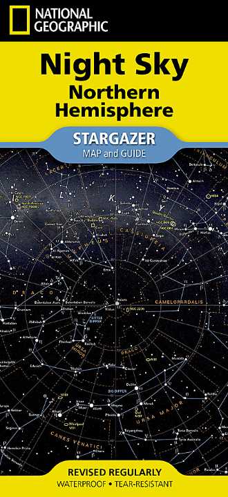
Night Sky - Northern Hemisphere Folded Map
Waterproof • Tear-Resistant • Seasonal Star Charts • Precision Celestial Mapping
There’s a moment — away from city lights — when the night sky reveals its full depth. Thousands of stars, subtle patterns, shifting constellations. The Night Sky — Northern Hemisphere Stargazer Map & Guide is designed to help you move beyond simply looking up… to truly understanding what you’re seeing.
Blending astronomical accuracy with practical usability, this map turns the sky into something readable, navigable, and endlessly fascinating — whether you’re standing in a backyard, on a mountain ridge, or deep in a dark-sky reserve.
🌌 A Sky Mapped with Purpose
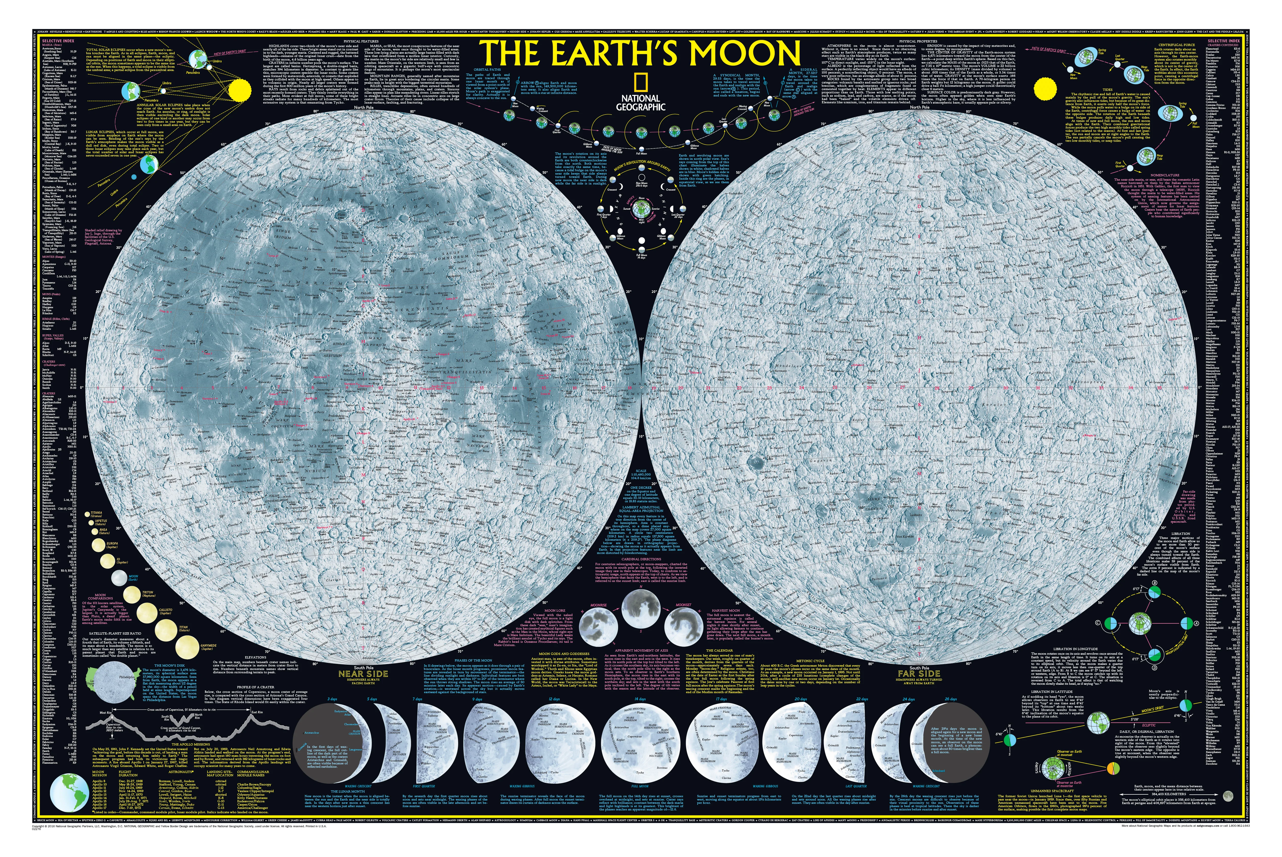
For thousands of years, humans have organised the stars into meaningful patterns. Today, astronomers formally recognise 88 constellations, dividing the sky into mapped regions — just like countries on Earth.
This map brings that system to life, giving you:
- A complete framework of the Northern Hemisphere sky
- Clearly defined constellation boundaries
- Major stars identified and labelled
- A structured way to navigate the heavens
It transforms the sky from a scatter of lights into a coherent, understandable map.
⭐ Centred on Polaris — Your Fixed Point in the Sky
At the heart of this map lies Polaris, the North Star — one of the most important celestial reference points in navigation.
Because Polaris sits almost directly above Earth’s rotational axis, it appears nearly motionless, while the rest of the sky rotates around it. This makes it an anchor for orientation.
Using Polaris, you can:
- Find true north instantly
- Estimate your latitude
- Understand how constellations rotate across the night
- Build real-world navigation skills
Once you locate Polaris, the rest of the sky begins to fall into place.
✨ What You’ll See — A Complete Stargazing Toolkit
This map is designed to be used, not just admired.
Core features:
- All 88 constellations clearly outlined
- Bright stars labelled with Latin astronomical names
- A star magnitude chart to interpret brightness
- High-contrast design for easy reading in low light
- Logical layout matching how the sky appears overhead
It’s effectively a field guide to the sky, built into a single, durable sheet.
🔄 Four Seasonal Sky Charts — Year-Round Use
The sky changes throughout the year as Earth orbits the Sun. To reflect this, the map includes four seasonal charts:
- 🌱 Spring
- ☀️ Summer
- 🍂 Autumn
- ❄️ Winter
Each chart shows the constellations visible during that season, helping you:
- Plan observing sessions
- Track the movement of constellations across months
- Understand how the sky evolves over time
This turns the map into a long-term learning tool, not just a one-night reference.
🌠 Build Real Stargazing Skills
With repeated use, this map helps you develop genuine astronomical awareness.
You’ll begin to:
- Recognise constellations instantly
- Understand nightly star movement (east to west rotation)
- Track seasonal shifts in the sky
- Use celestial patterns for orientation
For example, once you identify Ursa Major (the Big Dipper), you can use it to locate Polaris — reinforcing navigation skills that have been used for centuries.
🌌 From Backyard to Backcountry
Whether you’re observing casually or seriously, this map adapts to your environment.
Use it for:
- Backyard stargazing sessions
- Camping trips and remote travel
- Astronomy education and school programs
- Night photography planning
- Navigation awareness in outdoor settings
It’s equally useful for quick reference or deep learning.
🌏 Built for Real Conditions
Unlike paper charts, this map is designed for outdoor durability.
Printed on synthetic waterproof material, it offers:
- 💧 Resistance to dew, humidity, and light rain
- 💪 Tear resistance for rugged handling
- 🔁 Long-term durability under repeated folding
- 🌙 Easy handling in low-light conditions
This is a map you can rely on — even when conditions aren’t perfect.
🔭 Accessible for Beginners — Valuable for Enthusiasts
The map strikes a rare balance: simple enough for beginners, detailed enough for ongoing use.
Perfect for:
- First-time stargazers learning the basics
- Families introducing children to astronomy
- Teachers and educators
- Amateur astronomers
- Travellers and outdoor enthusiasts
It’s also an exceptional gift — combining science, beauty, and practicality.
📐 Specifications
| Feature | Detail |
|---|---|
| Title | Night Sky — Northern Hemisphere |
| Publisher | National Geographic Maps |
| Format | Folded stargazer map & guide |
| Material | Waterproof, tear-resistant synthetic paper |
| Flat Size | approx. 470 × 640 mm (18.5" × 25.25") |
| Folded Size | approx. 108 × 235 mm (4.25" × 9.25") |
| ISBN | 9781566959506 |
| Edition | 2024 |
| Coverage | Northern Hemisphere night sky |
| Charts Included | Spring • Summer • Autumn • Winter |
🎯 Why This Map Stands Out
- Purpose-built for Northern Hemisphere observers
- Anchored on Polaris for intuitive navigation
- Combines education, navigation, and usability
- Includes seasonal charts for year-round relevance
- Built for real outdoor conditions
🌌 A Different Way to See the Sky
The first time you use this map, something shifts.
The sky becomes familiar. Patterns emerge. Movement makes sense.
You stop guessing — and start recognising.
What once felt infinite becomes understandable, navigable, and deeply connected.
📦 Availability
This map is order on demand, ensuring the latest edition is supplied.
⏳ Please allow up to 10 business days for delivery.
Look up — and start reading the night sky like a map.
Product Information
Product Information
Shipping & Returns
Shipping & Returns
Description
Waterproof • Tear-Resistant • Seasonal Star Charts • Precision Celestial Mapping
There’s a moment — away from city lights — when the night sky reveals its full depth. Thousands of stars, subtle patterns, shifting constellations. The Night Sky — Northern Hemisphere Stargazer Map & Guide is designed to help you move beyond simply looking up… to truly understanding what you’re seeing.
Blending astronomical accuracy with practical usability, this map turns the sky into something readable, navigable, and endlessly fascinating — whether you’re standing in a backyard, on a mountain ridge, or deep in a dark-sky reserve.
🌌 A Sky Mapped with Purpose
For thousands of years, humans have organised the stars into meaningful patterns. Today, astronomers formally recognise 88 constellations, dividing the sky into mapped regions — just like countries on Earth.
This map brings that system to life, giving you:
- A complete framework of the Northern Hemisphere sky
- Clearly defined constellation boundaries
- Major stars identified and labelled
- A structured way to navigate the heavens
It transforms the sky from a scatter of lights into a coherent, understandable map.
⭐ Centred on Polaris — Your Fixed Point in the Sky
At the heart of this map lies Polaris, the North Star — one of the most important celestial reference points in navigation.
Because Polaris sits almost directly above Earth’s rotational axis, it appears nearly motionless, while the rest of the sky rotates around it. This makes it an anchor for orientation.
Using Polaris, you can:
- Find true north instantly
- Estimate your latitude
- Understand how constellations rotate across the night
- Build real-world navigation skills
Once you locate Polaris, the rest of the sky begins to fall into place.
✨ What You’ll See — A Complete Stargazing Toolkit
This map is designed to be used, not just admired.
Core features:
- All 88 constellations clearly outlined
- Bright stars labelled with Latin astronomical names
- A star magnitude chart to interpret brightness
- High-contrast design for easy reading in low light
- Logical layout matching how the sky appears overhead
It’s effectively a field guide to the sky, built into a single, durable sheet.
🔄 Four Seasonal Sky Charts — Year-Round Use
The sky changes throughout the year as Earth orbits the Sun. To reflect this, the map includes four seasonal charts:
- 🌱 Spring
- ☀️ Summer
- 🍂 Autumn
- ❄️ Winter
Each chart shows the constellations visible during that season, helping you:
- Plan observing sessions
- Track the movement of constellations across months
- Understand how the sky evolves over time
This turns the map into a long-term learning tool, not just a one-night reference.
🌠 Build Real Stargazing Skills
With repeated use, this map helps you develop genuine astronomical awareness.
You’ll begin to:
- Recognise constellations instantly
- Understand nightly star movement (east to west rotation)
- Track seasonal shifts in the sky
- Use celestial patterns for orientation
For example, once you identify Ursa Major (the Big Dipper), you can use it to locate Polaris — reinforcing navigation skills that have been used for centuries.
🌌 From Backyard to Backcountry
Whether you’re observing casually or seriously, this map adapts to your environment.
Use it for:
- Backyard stargazing sessions
- Camping trips and remote travel
- Astronomy education and school programs
- Night photography planning
- Navigation awareness in outdoor settings
It’s equally useful for quick reference or deep learning.
🌏 Built for Real Conditions
Unlike paper charts, this map is designed for outdoor durability.
Printed on synthetic waterproof material, it offers:
- 💧 Resistance to dew, humidity, and light rain
- 💪 Tear resistance for rugged handling
- 🔁 Long-term durability under repeated folding
- 🌙 Easy handling in low-light conditions
This is a map you can rely on — even when conditions aren’t perfect.
🔭 Accessible for Beginners — Valuable for Enthusiasts
The map strikes a rare balance: simple enough for beginners, detailed enough for ongoing use.
Perfect for:
- First-time stargazers learning the basics
- Families introducing children to astronomy
- Teachers and educators
- Amateur astronomers
- Travellers and outdoor enthusiasts
It’s also an exceptional gift — combining science, beauty, and practicality.
📐 Specifications
| Feature | Detail |
|---|---|
| Title | Night Sky — Northern Hemisphere |
| Publisher | National Geographic Maps |
| Format | Folded stargazer map & guide |
| Material | Waterproof, tear-resistant synthetic paper |
| Flat Size | approx. 470 × 640 mm (18.5" × 25.25") |
| Folded Size | approx. 108 × 235 mm (4.25" × 9.25") |
| ISBN | 9781566959506 |
| Edition | 2024 |
| Coverage | Northern Hemisphere night sky |
| Charts Included | Spring • Summer • Autumn • Winter |
🎯 Why This Map Stands Out
- Purpose-built for Northern Hemisphere observers
- Anchored on Polaris for intuitive navigation
- Combines education, navigation, and usability
- Includes seasonal charts for year-round relevance
- Built for real outdoor conditions
🌌 A Different Way to See the Sky
The first time you use this map, something shifts.
The sky becomes familiar. Patterns emerge. Movement makes sense.
You stop guessing — and start recognising.
What once felt infinite becomes understandable, navigable, and deeply connected.
📦 Availability
This map is order on demand, ensuring the latest edition is supplied.
⏳ Please allow up to 10 business days for delivery.
Look up — and start reading the night sky like a map.