Nile Valley, Land of the Pharaohs Index - Published 1965 by National Geographic
Historical Companion Map | Ancient Egypt Overview & Map Index | Wall Format (631 × 480 mm) | Premium Finishes
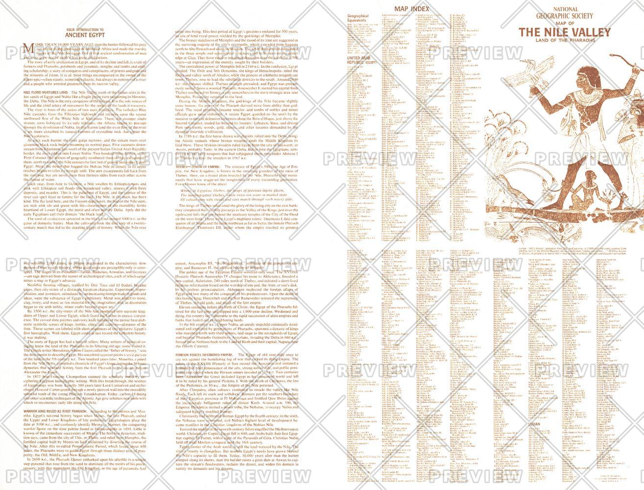
A rich introduction to one of the world’s great civilisations, Nile Valley, Land of the Pharaohs — Index Map serves as both a guide and companion to the main Nile Valley map. Published by National Geographic in May 1965, this piece brings together historical narrative, geographic context, and reference detail to illuminate the story of Ancient Egypt.
Presented as a four-panel educational overview, it explores how the Nile shaped a civilisation that would endure for millennia.
Why This Map Stands Out
A gateway to Ancient Egypt
Introduces the key themes and timelines of one of history’s महान civilisations.
Companion index map
Designed to support and enhance the main Nile Valley wall map.
Narrative and cartography combined
Blends informative text with geographic reference.
Classic National Geographic presentation
Mid-century design with clear structure and readability.
A unique collector’s piece
Ideal alongside the primary Nile Valley map.
🗺️ What the Map Shows
- A structured introduction to Ancient Egypt, including:
- The role of the Nile River and its annual flooding
- The rise of the first pharaohs
- The sequence of Egyptian dynasties
- The eventual decline of the civilisation
- A map index referencing locations on the main Nile Valley, Land of the Pharaohs map
- A clear framework linking geography, history, and culture
📐 Size & Format
631 mm (W) × 480 mm (H)
Landscape orientation
A practical format ideal for:
- Classrooms and history education
- Home studies and libraries
- Museum-style displays
- Pairing with the main Nile Valley map
✨ Premium Finishes
| Format | Description |
|---|---|
| 📜 Paper (160 gsm) | Heavyweight matte-coated paper—ideal for framing. Preserves clarity of text and diagrams. |
| 🧼 Laminated (Encapsulated) | Sealed in 2 × 80-micron gloss laminate. Durable and suitable for frequent reference. |
| 🪵 Laminated + Timber Hang Rails | Laminated map mounted with lacquered natural timber rails and hanging cord—ready to display. |
| 🖼️ Canvas (395 gsm HP Professional Matte) | Printed with archival pigment inks. Adds depth and a refined finish. |
| 🪵 Canvas + Timber Hang Rails | Canvas paired with timber rails for a gallery-style presentation. |
🔨 Please allow up to 10 working days for professionally mounted hang-railed finishes.
📊 Specifications
| Feature | Detail |
|---|---|
| Title | Nile Valley, Land of the Pharaohs — Index Map |
| Publisher | National Geographic |
| Published | 1965 |
| Dimensions | 631 mm × 480 mm |
| Orientation | Landscape |
| Map Type | Historical / Educational / Index |
| Coverage | Nile Valley & Ancient Egypt |
| Collections | Africa, Historical |
| Materials | 160 gsm matte paper / 2 × 80-micron laminate / 395 gsm HP Professional Matte Canvas |
| Printing | Pigment-based, fade-resistant inks |
| Origin | Printed in Australia |
🎯 Ideal For
- Students and educators of Ancient Egyptian history
- Collectors of National Geographic historical maps
- Those pairing with the main Nile Valley map
- Interiors seeking a museum-style educational display
- Gift buyers looking for a thoughtful historical companion piece
🏺 The River That Built a Civilisation
Ancient Egypt was shaped by the Nile:
- Annual floods nourishing fertile land
- Dynasties rising along its banks
- A civilisation defined by continuity and innovation
- A legacy that continues to inspire
This map captures that story—offering a clear and engaging introduction to a world where river, land, and culture were inseparable.
🤝 Our Commitment
- Printed in Australia using archival-quality production
- Faithfully reproduced to preserve clarity of text and detail
- Premium materials selected for durability and longevity
- Each map is hand-checked before dispatch
- Carefully packaged for safe delivery
🚚 Delivery
- Paper, Laminated, Canvas (rolled): Dispatch within 1–2 business days
- Hang-Railed Maps: Made to order—allow up to 10 working days
- Packaging: Securely rolled in protective tubing
Step into the world of the pharaohs—
a map that brings Ancient Egypt’s story into clear, structured focus.
👉 Order now and complete your Nile Valley collection.
Product Information
Product Information
Shipping & Returns
Shipping & Returns
Description
Historical Companion Map | Ancient Egypt Overview & Map Index | Wall Format (631 × 480 mm) | Premium Finishes
A rich introduction to one of the world’s great civilisations, Nile Valley, Land of the Pharaohs — Index Map serves as both a guide and companion to the main Nile Valley map. Published by National Geographic in May 1965, this piece brings together historical narrative, geographic context, and reference detail to illuminate the story of Ancient Egypt.
Presented as a four-panel educational overview, it explores how the Nile shaped a civilisation that would endure for millennia.
Why This Map Stands Out
A gateway to Ancient Egypt
Introduces the key themes and timelines of one of history’s महान civilisations.
Companion index map
Designed to support and enhance the main Nile Valley wall map.
Narrative and cartography combined
Blends informative text with geographic reference.
Classic National Geographic presentation
Mid-century design with clear structure and readability.
A unique collector’s piece
Ideal alongside the primary Nile Valley map.
🗺️ What the Map Shows
- A structured introduction to Ancient Egypt, including:
- The role of the Nile River and its annual flooding
- The rise of the first pharaohs
- The sequence of Egyptian dynasties
- The eventual decline of the civilisation
- A map index referencing locations on the main Nile Valley, Land of the Pharaohs map
- A clear framework linking geography, history, and culture
📐 Size & Format
631 mm (W) × 480 mm (H)
Landscape orientation
A practical format ideal for:
- Classrooms and history education
- Home studies and libraries
- Museum-style displays
- Pairing with the main Nile Valley map
✨ Premium Finishes
| Format | Description |
|---|---|
| 📜 Paper (160 gsm) | Heavyweight matte-coated paper—ideal for framing. Preserves clarity of text and diagrams. |
| 🧼 Laminated (Encapsulated) | Sealed in 2 × 80-micron gloss laminate. Durable and suitable for frequent reference. |
| 🪵 Laminated + Timber Hang Rails | Laminated map mounted with lacquered natural timber rails and hanging cord—ready to display. |
| 🖼️ Canvas (395 gsm HP Professional Matte) | Printed with archival pigment inks. Adds depth and a refined finish. |
| 🪵 Canvas + Timber Hang Rails | Canvas paired with timber rails for a gallery-style presentation. |
🔨 Please allow up to 10 working days for professionally mounted hang-railed finishes.
📊 Specifications
| Feature | Detail |
|---|---|
| Title | Nile Valley, Land of the Pharaohs — Index Map |
| Publisher | National Geographic |
| Published | 1965 |
| Dimensions | 631 mm × 480 mm |
| Orientation | Landscape |
| Map Type | Historical / Educational / Index |
| Coverage | Nile Valley & Ancient Egypt |
| Collections | Africa, Historical |
| Materials | 160 gsm matte paper / 2 × 80-micron laminate / 395 gsm HP Professional Matte Canvas |
| Printing | Pigment-based, fade-resistant inks |
| Origin | Printed in Australia |
🎯 Ideal For
- Students and educators of Ancient Egyptian history
- Collectors of National Geographic historical maps
- Those pairing with the main Nile Valley map
- Interiors seeking a museum-style educational display
- Gift buyers looking for a thoughtful historical companion piece
🏺 The River That Built a Civilisation
Ancient Egypt was shaped by the Nile:
- Annual floods nourishing fertile land
- Dynasties rising along its banks
- A civilisation defined by continuity and innovation
- A legacy that continues to inspire
This map captures that story—offering a clear and engaging introduction to a world where river, land, and culture were inseparable.
🤝 Our Commitment
- Printed in Australia using archival-quality production
- Faithfully reproduced to preserve clarity of text and detail
- Premium materials selected for durability and longevity
- Each map is hand-checked before dispatch
- Carefully packaged for safe delivery
🚚 Delivery
- Paper, Laminated, Canvas (rolled): Dispatch within 1–2 business days
- Hang-Railed Maps: Made to order—allow up to 10 working days
- Packaging: Securely rolled in protective tubing
Step into the world of the pharaohs—
a map that brings Ancient Egypt’s story into clear, structured focus.
👉 Order now and complete your Nile Valley collection.


