North America Political & Physical Continent Map
Dual-View Reference | Political & Topographic Detail | Large Wall Format (1000 × 627 mm) | Premium Finishes
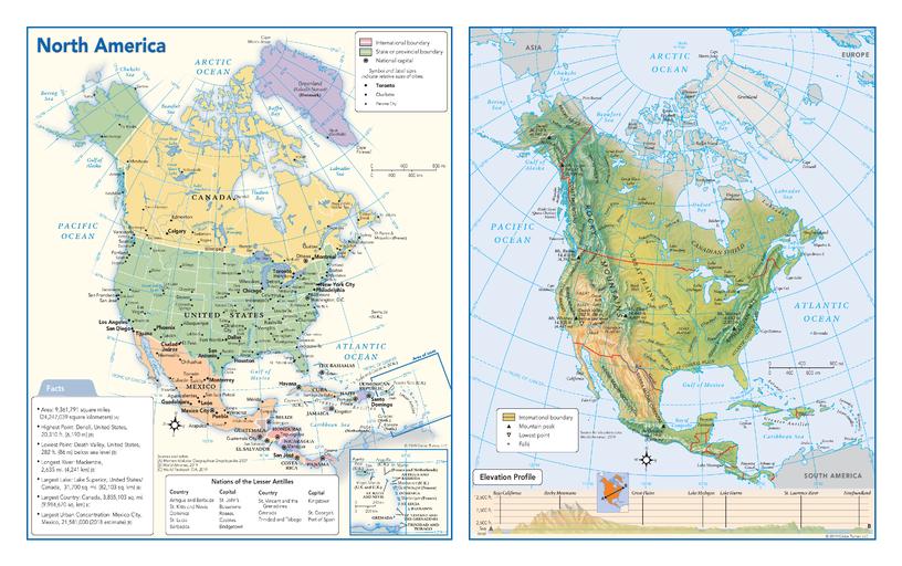
A clear, large-format map that brings North America into sharp focus—combining political structure and physical geography in one beautifully balanced, easy-to-read design.
Published by Globe Turner, this wall map presents a detailed political view alongside a vibrant physical map, allowing you to understand both how North America is divided and how it is shaped. From the Rocky Mountains to the Great Plains, from Arctic tundra to tropical regions, every feature is rendered with clarity and purpose.
At this generous width, the map delivers excellent readability and strong wall presence, making it ideal for both education and display.
Why This Map Stands Out
Two maps in one
A detailed political map paired with a richly coloured physical map—offering a complete continental perspective.
Designed for clarity at scale
At one metre wide, the map provides excellent readability across countries, cities, and terrain.
Topography brought to life
Relief shading highlights mountains, plains, and river systems with clarity.
Educational insight built in
Includes a fact panel and elevation profile—ideal for classrooms and quick reference.
A versatile wall map
Balances functionality with visual appeal—perfect for study, planning, or display.
🗺️ What the Map Shows
- A full political map of North America with countries, capitals, and major cities clearly labelled
- A detailed physical map showing mountain ranges, rivers, plains, and elevation zones
- Major geographic features including the Rocky Mountains, Appalachian Mountains, and Sierra Madre ranges
- Key river systems such as the Mississippi, Mackenzie, and St. Lawrence
- A cross-continent elevation profile illustrating terrain variation
- A fact panel with key insights about North America
📐 Size & Format
1000 mm (W) × 627 mm (H)
Landscape orientation
A wide, wall-friendly format that enhances clarity and usability—ideal for:
- Classrooms and lecture spaces
- Offices and planning environments
- Libraries and study areas
- Feature walls needing both scale and readability
✨ Premium Finishes
| Format | Description |
|---|---|
| 📜 Paper (160 gsm) | Heavyweight matte-coated paper—ideal for framing. Crisp detail with a low-glare finish. |
| 🧼 Laminated (Encapsulated) | Sealed in 2 × 80-micron gloss laminate. Durable, wipe-clean, and perfect for frequent use. |
| 🪵 Laminated + Timber Hang Rails | Laminated map mounted with lacquered natural timber rails and hanging cord—ready to display. |
| 🖼️ Canvas (395 gsm HP Professional Matte) | Printed with archival pigment inks. Rich texture and gallery-quality presentation. |
| 🪵 Canvas + Timber Hang Rails | Canvas paired with timber rails for a refined, frame-free display solution. |
🔨 Please allow up to 10 working days for professionally mounted hang-railed finishes.
📊 Specifications
| Feature | Detail |
|---|---|
| Title | North America — Political & Physical Continent Map |
| Publisher | Globe Turner |
| Published | 2019 |
| Dimensions | 1000 mm (W) × 627 mm (H) |
| Orientation | Landscape |
| Map Type | Political & Physical (Dual Map) |
| Features | Countries, cities, terrain, elevation profile, fact panel |
| Materials | 160 gsm matte paper / 2 × 80-micron laminate / 395 gsm HP Professional Matte Canvas |
| Printing | Pigment-based, fade-resistant inks |
| Origin | Printed in Australia |
🎯 Ideal For
- Educators and students studying North American geography and regions
- Classrooms and learning environments
- Offices needing a large, readable continental reference map
- Travellers and geography enthusiasts
- Gift buyers seeking an informative and visually engaging wall map
🌎 A Continent of Scale and Diversity
North America is defined by its geographic range:
- Mountain chains shaping climate and settlement
- Vast plains supporting agriculture and development
- River systems connecting regions and economies
By combining political and physical views, this map shows how landscape and human geography are closely linked across the continent.
🤝 Our Commitment
- Printed in Australia using archival-quality production
- Premium materials selected for clarity and durability
- Colour-managed for consistent readability
- Each map is hand-checked before dispatch
- Carefully packaged to ensure safe delivery
🚚 Delivery
- Paper, Laminated, Canvas (rolled): Dispatch within 1–2 business days
- Hang-Railed Maps: Made to order—allow up to 10 working days
- Packaging: Securely rolled in protective tubing
A continent brought into focus—clear, structured, and beautifully presented.
👉 Order now and explore North America from both a political and physical perspective.
Product Information
Product Information
Shipping & Returns
Shipping & Returns
Description
Dual-View Reference | Political & Topographic Detail | Large Wall Format (1000 × 627 mm) | Premium Finishes
A clear, large-format map that brings North America into sharp focus—combining political structure and physical geography in one beautifully balanced, easy-to-read design.
Published by Globe Turner, this wall map presents a detailed political view alongside a vibrant physical map, allowing you to understand both how North America is divided and how it is shaped. From the Rocky Mountains to the Great Plains, from Arctic tundra to tropical regions, every feature is rendered with clarity and purpose.
At this generous width, the map delivers excellent readability and strong wall presence, making it ideal for both education and display.
Why This Map Stands Out
Two maps in one
A detailed political map paired with a richly coloured physical map—offering a complete continental perspective.
Designed for clarity at scale
At one metre wide, the map provides excellent readability across countries, cities, and terrain.
Topography brought to life
Relief shading highlights mountains, plains, and river systems with clarity.
Educational insight built in
Includes a fact panel and elevation profile—ideal for classrooms and quick reference.
A versatile wall map
Balances functionality with visual appeal—perfect for study, planning, or display.
🗺️ What the Map Shows
- A full political map of North America with countries, capitals, and major cities clearly labelled
- A detailed physical map showing mountain ranges, rivers, plains, and elevation zones
- Major geographic features including the Rocky Mountains, Appalachian Mountains, and Sierra Madre ranges
- Key river systems such as the Mississippi, Mackenzie, and St. Lawrence
- A cross-continent elevation profile illustrating terrain variation
- A fact panel with key insights about North America
📐 Size & Format
1000 mm (W) × 627 mm (H)
Landscape orientation
A wide, wall-friendly format that enhances clarity and usability—ideal for:
- Classrooms and lecture spaces
- Offices and planning environments
- Libraries and study areas
- Feature walls needing both scale and readability
✨ Premium Finishes
| Format | Description |
|---|---|
| 📜 Paper (160 gsm) | Heavyweight matte-coated paper—ideal for framing. Crisp detail with a low-glare finish. |
| 🧼 Laminated (Encapsulated) | Sealed in 2 × 80-micron gloss laminate. Durable, wipe-clean, and perfect for frequent use. |
| 🪵 Laminated + Timber Hang Rails | Laminated map mounted with lacquered natural timber rails and hanging cord—ready to display. |
| 🖼️ Canvas (395 gsm HP Professional Matte) | Printed with archival pigment inks. Rich texture and gallery-quality presentation. |
| 🪵 Canvas + Timber Hang Rails | Canvas paired with timber rails for a refined, frame-free display solution. |
🔨 Please allow up to 10 working days for professionally mounted hang-railed finishes.
📊 Specifications
| Feature | Detail |
|---|---|
| Title | North America — Political & Physical Continent Map |
| Publisher | Globe Turner |
| Published | 2019 |
| Dimensions | 1000 mm (W) × 627 mm (H) |
| Orientation | Landscape |
| Map Type | Political & Physical (Dual Map) |
| Features | Countries, cities, terrain, elevation profile, fact panel |
| Materials | 160 gsm matte paper / 2 × 80-micron laminate / 395 gsm HP Professional Matte Canvas |
| Printing | Pigment-based, fade-resistant inks |
| Origin | Printed in Australia |
🎯 Ideal For
- Educators and students studying North American geography and regions
- Classrooms and learning environments
- Offices needing a large, readable continental reference map
- Travellers and geography enthusiasts
- Gift buyers seeking an informative and visually engaging wall map
🌎 A Continent of Scale and Diversity
North America is defined by its geographic range:
- Mountain chains shaping climate and settlement
- Vast plains supporting agriculture and development
- River systems connecting regions and economies
By combining political and physical views, this map shows how landscape and human geography are closely linked across the continent.
🤝 Our Commitment
- Printed in Australia using archival-quality production
- Premium materials selected for clarity and durability
- Colour-managed for consistent readability
- Each map is hand-checked before dispatch
- Carefully packaged to ensure safe delivery
🚚 Delivery
- Paper, Laminated, Canvas (rolled): Dispatch within 1–2 business days
- Hang-Railed Maps: Made to order—allow up to 10 working days
- Packaging: Securely rolled in protective tubing
A continent brought into focus—clear, structured, and beautifully presented.
👉 Order now and explore North America from both a political and physical perspective.


