North American Indian Cultures by National Geographic
Cultural & Linguistic Wall Map | Indigenous Peoples of North America | Wall Format (787 × 508 mm) | Premium Finishes
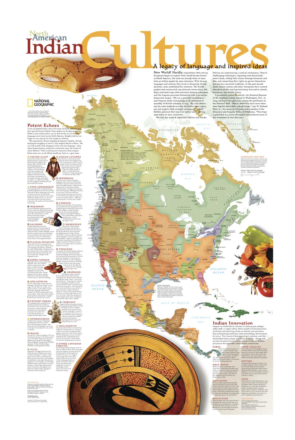
A powerful and respectful exploration of the continent’s first peoples, North American Indian Cultures reveals the extraordinary diversity of languages, traditions, and innovations that shaped life across North America long before European arrival. Published by National Geographic, this map brings together linguistic geography, cultural insight, and historical context in a richly detailed and visually engaging format.
Spanning from Central America to the Arctic—and including Greenland and the Caribbean—it presents a continent defined by cultural depth and ingenuity.
Why This Map Stands Out
A continent of cultures
Highlights the diversity of Indigenous societies across North America.
Linguistic insight at scale
Maps major language families and their geographic distribution.
Educational and respectful
Presents cultural history with clarity and depth.
Innovation and ingenuity
Showcases Indigenous contributions to technology, medicine, and survival.
A meaningful wall map
Ideal for learning, reflection, and display.
🗺️ What the Map Shows
- A broad sampling of Indigenous linguistic families across the continent
- Geographic distribution of language groups and cultural regions
- Coverage spanning:
- Central America
- The United States and Canada
- Alaska
- Greenland and the Caribbean Islands
- Descriptions of each language group and cultural traditions
- A special inset highlighting Indigenous innovations, including:
- Clothing such as parkas
- Tools like snow goggles
- Advances in medicine and agriculture
- A framework linking language, land, and cultural identity
📐 Size & Format
787 mm (H) × 508 mm (W)
Portrait orientation
A versatile format ideal for:
- Classrooms and cultural studies
- Home libraries and studies
- Museums and educational displays
- Interiors seeking meaningful, knowledge-rich artwork
✨ Premium Finishes
| Format | Description |
|---|---|
| 📜 Paper (160 gsm) | Heavyweight matte-coated paper—ideal for framing. Preserves clarity in text and detail. |
| 🧼 Laminated (Encapsulated) | Sealed in 2 × 80-micron gloss laminate. Durable and suitable for frequent reference. |
| 🪵 Laminated + Timber Hang Rails | Laminated map mounted with lacquered natural timber rails and hanging cord—ready to display. |
| 🖼️ Canvas (395 gsm HP Professional Matte) | Printed with archival pigment inks. Adds depth and a refined presentation. |
| 🪵 Canvas + Timber Hang Rails | Canvas paired with timber rails for a gallery-style finish. |
🔨 Please allow up to 10 working days for professionally mounted hang-railed finishes.
📊 Specifications
| Feature | Detail |
|---|---|
| Title | North American Indian Cultures |
| Publisher | National Geographic |
| Published | 2004 |
| Dimensions | 787 mm × 508 mm |
| Orientation | Portrait |
| Map Type | Cultural / Thematic |
| Coverage | North America, Central America, Greenland & Caribbean |
| Collections | North America, Thematic |
| Materials | 160 gsm matte paper / 2 × 80-micron laminate / 395 gsm HP Professional Matte Canvas |
| Printing | Pigment-based, fade-resistant inks |
| Origin | Printed in Australia |
🎯 Ideal For
- Students and educators of Indigenous cultures and history
- Those interested in linguistics and cultural geography
- Collectors of National Geographic thematic maps
- Institutions and spaces focused on education and heritage
- Gift buyers looking for a thoughtful and meaningful map
🌎 A Legacy of Language and Innovation
Before European exploration:
- Tens of millions of people lived across the continent
- Hundreds of languages expressed distinct worldviews
- Cultures adapted ingeniously to diverse environments
- Knowledge systems shaped survival, trade, and identity
This map captures that richness—offering a clear and compelling view of a continent where language, culture, and land are deeply intertwined.
🤝 Our Commitment
- Printed in Australia using archival-quality production
- Faithfully reproduced to preserve clarity and cultural detail
- Premium materials selected for durability and longevity
- Each map is hand-checked before dispatch
- Carefully packaged for safe delivery
🚚 Delivery
- Paper, Laminated, Canvas (rolled): Dispatch within 1–2 business days
- Hang-Railed Maps: Made to order—allow up to 10 working days
- Packaging: Securely rolled in protective tubing
Discover the depth of a continent’s first cultures—
a map that brings Indigenous North America into meaningful focus.
👉 Order now and pair it with the Indian Country map for a fuller story.
Product Information
Product Information
Shipping & Returns
Shipping & Returns
Description
Cultural & Linguistic Wall Map | Indigenous Peoples of North America | Wall Format (787 × 508 mm) | Premium Finishes
A powerful and respectful exploration of the continent’s first peoples, North American Indian Cultures reveals the extraordinary diversity of languages, traditions, and innovations that shaped life across North America long before European arrival. Published by National Geographic, this map brings together linguistic geography, cultural insight, and historical context in a richly detailed and visually engaging format.
Spanning from Central America to the Arctic—and including Greenland and the Caribbean—it presents a continent defined by cultural depth and ingenuity.
Why This Map Stands Out
A continent of cultures
Highlights the diversity of Indigenous societies across North America.
Linguistic insight at scale
Maps major language families and their geographic distribution.
Educational and respectful
Presents cultural history with clarity and depth.
Innovation and ingenuity
Showcases Indigenous contributions to technology, medicine, and survival.
A meaningful wall map
Ideal for learning, reflection, and display.
🗺️ What the Map Shows
- A broad sampling of Indigenous linguistic families across the continent
- Geographic distribution of language groups and cultural regions
- Coverage spanning:
- Central America
- The United States and Canada
- Alaska
- Greenland and the Caribbean Islands
- Descriptions of each language group and cultural traditions
- A special inset highlighting Indigenous innovations, including:
- Clothing such as parkas
- Tools like snow goggles
- Advances in medicine and agriculture
- A framework linking language, land, and cultural identity
📐 Size & Format
787 mm (H) × 508 mm (W)
Portrait orientation
A versatile format ideal for:
- Classrooms and cultural studies
- Home libraries and studies
- Museums and educational displays
- Interiors seeking meaningful, knowledge-rich artwork
✨ Premium Finishes
| Format | Description |
|---|---|
| 📜 Paper (160 gsm) | Heavyweight matte-coated paper—ideal for framing. Preserves clarity in text and detail. |
| 🧼 Laminated (Encapsulated) | Sealed in 2 × 80-micron gloss laminate. Durable and suitable for frequent reference. |
| 🪵 Laminated + Timber Hang Rails | Laminated map mounted with lacquered natural timber rails and hanging cord—ready to display. |
| 🖼️ Canvas (395 gsm HP Professional Matte) | Printed with archival pigment inks. Adds depth and a refined presentation. |
| 🪵 Canvas + Timber Hang Rails | Canvas paired with timber rails for a gallery-style finish. |
🔨 Please allow up to 10 working days for professionally mounted hang-railed finishes.
📊 Specifications
| Feature | Detail |
|---|---|
| Title | North American Indian Cultures |
| Publisher | National Geographic |
| Published | 2004 |
| Dimensions | 787 mm × 508 mm |
| Orientation | Portrait |
| Map Type | Cultural / Thematic |
| Coverage | North America, Central America, Greenland & Caribbean |
| Collections | North America, Thematic |
| Materials | 160 gsm matte paper / 2 × 80-micron laminate / 395 gsm HP Professional Matte Canvas |
| Printing | Pigment-based, fade-resistant inks |
| Origin | Printed in Australia |
🎯 Ideal For
- Students and educators of Indigenous cultures and history
- Those interested in linguistics and cultural geography
- Collectors of National Geographic thematic maps
- Institutions and spaces focused on education and heritage
- Gift buyers looking for a thoughtful and meaningful map
🌎 A Legacy of Language and Innovation
Before European exploration:
- Tens of millions of people lived across the continent
- Hundreds of languages expressed distinct worldviews
- Cultures adapted ingeniously to diverse environments
- Knowledge systems shaped survival, trade, and identity
This map captures that richness—offering a clear and compelling view of a continent where language, culture, and land are deeply intertwined.
🤝 Our Commitment
- Printed in Australia using archival-quality production
- Faithfully reproduced to preserve clarity and cultural detail
- Premium materials selected for durability and longevity
- Each map is hand-checked before dispatch
- Carefully packaged for safe delivery
🚚 Delivery
- Paper, Laminated, Canvas (rolled): Dispatch within 1–2 business days
- Hang-Railed Maps: Made to order—allow up to 10 working days
- Packaging: Securely rolled in protective tubing
Discover the depth of a continent’s first cultures—
a map that brings Indigenous North America into meaningful focus.
👉 Order now and pair it with the Indian Country map for a fuller story.


