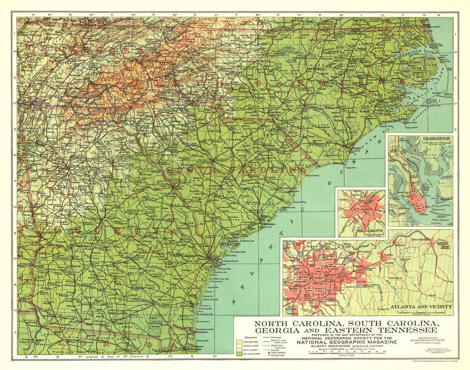
North Carolina, South Carolina, Georgia and Eastern Tennessee - Published 1926 by National Geographic
North Carolina, South Carolina, Georgia and Eastern Tennessee - Published 1926 by National Geographic
Historical Regional Map | Post–Civil War South & Urban Insets | Wall Format (504 × 397 mm) | Premium Finishes
A finely balanced portrait of the American South in transition, this 1926 map captures a region still shaped by the legacy of the American Civil War while moving into a new era of growth and connectivity. Published by National Geographic, it presents a detailed and historically rich view across North Carolina, South Carolina, Georgia, and eastern Tennessee.
Produced just over sixty years after defining wartime events—including the Burning of Atlanta—this map reflects a landscape where history, recovery, and development intersect.
Why This Map Stands Out
A region in transition
Captures the South in the decades following the Civil War.
Classic National Geographic cartography
Clear, detailed, and balanced in both geography and presentation.
Urban detail included
Inset maps provide close-up views of key southern cities.
Historical context with geographic clarity
Links landscape with the legacy of conflict and reconstruction.
A compact collector’s piece
Ideal for heritage displays and curated collections.
🗺️ What the Map Shows
- The southeastern United States, including:
- North Carolina, South Carolina, Georgia, and eastern Tennessee
- Regional geography:
- Rivers, mountains, and coastal plains
- Towns, cities, and transport networks across the region
- Inset maps offering detailed views of:
- Atlanta
- Charlotte
- Charleston
- A broader framework linking history, settlement, and regional development
📐 Size & Format
504 mm (W) × 397 mm (H)
Landscape orientation
A compact, display-friendly format ideal for:
- Framed historical map collections
- Home offices and studies
- Libraries and heritage displays
- Interiors with a southern or historical theme
✨ Premium Finishes
| Format | Description |
|---|---|
| 📜 Paper (160 gsm) | Heavyweight matte-coated paper—ideal for framing. Preserves fine cartographic detail. |
| 🧼 Laminated (Encapsulated) | Sealed in 2 × 80-micron gloss laminate. Durable and protective for long-term display. |
| 🪵 Laminated + Timber Hang Rails | Laminated map mounted with lacquered natural timber rails and hanging cord—ready to display. |
| 🖼️ Canvas (395 gsm HP Professional Matte) | Printed with archival pigment inks. Adds depth and a refined presentation finish. |
| 🪵 Canvas + Timber Hang Rails | Canvas paired with timber rails for a gallery-style display. |
🔨 Please allow up to 10 working days for professionally mounted hang-railed finishes.
📊 Specifications
| Feature | Detail |
|---|---|
| Title | North Carolina, South Carolina, Georgia & Eastern Tennessee |
| Publisher | National Geographic |
| Published | 1926 |
| Scale | 1:2,000,000 |
| Dimensions | 504 mm × 397 mm |
| Orientation | Landscape |
| Map Type | Historical / Topographic |
| Coverage | Southeastern United States |
| Collections | USA, Historical, Topographic |
| Materials | 160 gsm matte paper / 2 × 80-micron laminate / 395 gsm HP Professional Matte Canvas |
| Printing | Pigment-based, fade-resistant inks |
| Origin | Printed in Australia |
🎯 Ideal For
- Collectors of historical American maps
- Enthusiasts of Southern U.S. history and geography
- Students of post–Civil War development
- Interiors seeking a classic, heritage-style display piece
- Gift buyers looking for a distinctive historical map
🌄 The South Reimagined
In the decades after the Civil War:
- Cities rebuilt and expanded
- Transport networks reshaped the region
- Landscapes carried the memory of conflict
- A new South began to emerge
This map captures that moment—offering a clear and compelling view of a region where history and progress are deeply intertwined.
🤝 Our Commitment
- Printed in Australia using archival-quality production
- Faithfully reproduced to preserve original detail and character
- Premium materials selected for durability and longevity
- Each map is hand-checked before dispatch
- Carefully packaged for safe delivery
🚚 Delivery
- Paper, Laminated, Canvas (rolled): Dispatch within 1–2 business days
- Hang-Railed Maps: Made to order—allow up to 10 working days
- Packaging: Securely rolled in protective tubing
Own a piece of Southern history—
a map that brings the post–Civil War landscape into sharp focus.
👉 Order now and add a classic 1920s regional map to your collection.
Original: $50.05
-65%$50.05
$17.52Product Information
Product Information
Shipping & Returns
Shipping & Returns
Description
Historical Regional Map | Post–Civil War South & Urban Insets | Wall Format (504 × 397 mm) | Premium Finishes
A finely balanced portrait of the American South in transition, this 1926 map captures a region still shaped by the legacy of the American Civil War while moving into a new era of growth and connectivity. Published by National Geographic, it presents a detailed and historically rich view across North Carolina, South Carolina, Georgia, and eastern Tennessee.
Produced just over sixty years after defining wartime events—including the Burning of Atlanta—this map reflects a landscape where history, recovery, and development intersect.
Why This Map Stands Out
A region in transition
Captures the South in the decades following the Civil War.
Classic National Geographic cartography
Clear, detailed, and balanced in both geography and presentation.
Urban detail included
Inset maps provide close-up views of key southern cities.
Historical context with geographic clarity
Links landscape with the legacy of conflict and reconstruction.
A compact collector’s piece
Ideal for heritage displays and curated collections.
🗺️ What the Map Shows
- The southeastern United States, including:
- North Carolina, South Carolina, Georgia, and eastern Tennessee
- Regional geography:
- Rivers, mountains, and coastal plains
- Towns, cities, and transport networks across the region
- Inset maps offering detailed views of:
- Atlanta
- Charlotte
- Charleston
- A broader framework linking history, settlement, and regional development
📐 Size & Format
504 mm (W) × 397 mm (H)
Landscape orientation
A compact, display-friendly format ideal for:
- Framed historical map collections
- Home offices and studies
- Libraries and heritage displays
- Interiors with a southern or historical theme
✨ Premium Finishes
| Format | Description |
|---|---|
| 📜 Paper (160 gsm) | Heavyweight matte-coated paper—ideal for framing. Preserves fine cartographic detail. |
| 🧼 Laminated (Encapsulated) | Sealed in 2 × 80-micron gloss laminate. Durable and protective for long-term display. |
| 🪵 Laminated + Timber Hang Rails | Laminated map mounted with lacquered natural timber rails and hanging cord—ready to display. |
| 🖼️ Canvas (395 gsm HP Professional Matte) | Printed with archival pigment inks. Adds depth and a refined presentation finish. |
| 🪵 Canvas + Timber Hang Rails | Canvas paired with timber rails for a gallery-style display. |
🔨 Please allow up to 10 working days for professionally mounted hang-railed finishes.
📊 Specifications
| Feature | Detail |
|---|---|
| Title | North Carolina, South Carolina, Georgia & Eastern Tennessee |
| Publisher | National Geographic |
| Published | 1926 |
| Scale | 1:2,000,000 |
| Dimensions | 504 mm × 397 mm |
| Orientation | Landscape |
| Map Type | Historical / Topographic |
| Coverage | Southeastern United States |
| Collections | USA, Historical, Topographic |
| Materials | 160 gsm matte paper / 2 × 80-micron laminate / 395 gsm HP Professional Matte Canvas |
| Printing | Pigment-based, fade-resistant inks |
| Origin | Printed in Australia |
🎯 Ideal For
- Collectors of historical American maps
- Enthusiasts of Southern U.S. history and geography
- Students of post–Civil War development
- Interiors seeking a classic, heritage-style display piece
- Gift buyers looking for a distinctive historical map
🌄 The South Reimagined
In the decades after the Civil War:
- Cities rebuilt and expanded
- Transport networks reshaped the region
- Landscapes carried the memory of conflict
- A new South began to emerge
This map captures that moment—offering a clear and compelling view of a region where history and progress are deeply intertwined.
🤝 Our Commitment
- Printed in Australia using archival-quality production
- Faithfully reproduced to preserve original detail and character
- Premium materials selected for durability and longevity
- Each map is hand-checked before dispatch
- Carefully packaged for safe delivery
🚚 Delivery
- Paper, Laminated, Canvas (rolled): Dispatch within 1–2 business days
- Hang-Railed Maps: Made to order—allow up to 10 working days
- Packaging: Securely rolled in protective tubing
Own a piece of Southern history—
a map that brings the post–Civil War landscape into sharp focus.
👉 Order now and add a classic 1920s regional map to your collection.


