North Carolina Tennessee Cumerberland Blue Ridge - Published 1889 by National Geographic
Historic Topographic Map | Early Survey Cartography | Wall Format (554 × 403 mm) | Premium Finishes
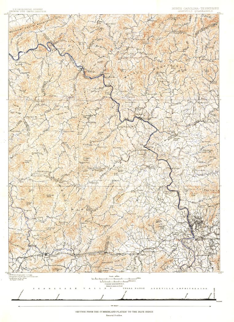
A finely detailed window into late 19th-century cartography, the Asheville Sheet captures a pivotal stretch of the southern Appalachian region—where rugged uplands meet the rising spine of the Blue Ridge. Published by National Geographic in October 1889, this map reflects the precision and ambition of early survey work across North Carolina and Tennessee.
From the broad uplands of the Cumberland Plateau to the dramatic ridgelines of the Blue Ridge Mountains, it offers a rare and beautifully composed record of the region at a formative moment in its mapped history.
Why This Map Stands Out
Authentic 19th-century cartography
Produced during an era of detailed ground surveys and early topographic mapping.
Regional depth and clarity
Captures both terrain and settlement patterns across a complex landscape.
Collector-grade historical piece
A distinctive map from the early years of National Geographic publishing.
Balanced composition
Combines natural features with towns and emerging infrastructure.
A refined wall map
Ideal for heritage interiors and curated collections.
🗺️ What the Map Shows
- The region spanning western North Carolina and eastern Tennessee
- The transition from the Cumberland Plateau to the Blue Ridge Mountains
- The city of Asheville and surrounding towns
- Early transport routes and settlement patterns
- Detailed topographic features reflecting elevation and terrain
- A snapshot of the Appalachian region during the late 1800s
📐 Size & Format
554 mm (W) × 403 mm (H)
Landscape orientation
A compact, display-friendly format ideal for:
- Framed historical map collections
- Home offices and studies
- Libraries and heritage displays
- Interiors with a vintage or Appalachian theme
✨ Premium Finishes
| Format | Description |
|---|---|
| 📜 Paper (160 gsm) | Heavyweight matte-coated paper—ideal for framing. Preserves fine linework and historical detail. |
| 🧼 Laminated (Encapsulated) | Sealed in 2 × 80-micron gloss laminate. Durable and protective for long-term display. |
| 🪵 Laminated + Timber Hang Rails | Laminated map mounted with lacquered natural timber rails and hanging cord—ready to display. |
| 🖼️ Canvas (395 gsm HP Professional Matte) | Printed with archival pigment inks. Adds depth and a classic presentation finish. |
| 🪵 Canvas + Timber Hang Rails | Canvas paired with timber rails for a refined, gallery-style display. |
🔨 Please allow up to 10 working days for professionally mounted hang-railed finishes.
📊 Specifications
| Feature | Detail |
|---|---|
| Title | North Carolina–Tennessee: Asheville Sheet |
| Publisher | National Geographic |
| Published | 1889 |
| Scale | 1:125,000 |
| Dimensions | 554 mm × 403 mm |
| Orientation | Landscape |
| Map Type | Historical / Topographic |
| Coverage | Western North Carolina & Eastern Tennessee |
| Collections | USA, Historical, Topographic |
| Materials | 160 gsm matte paper / 2 × 80-micron laminate / 395 gsm HP Professional Matte Canvas |
| Printing | Pigment-based, fade-resistant inks |
| Origin | Printed in Australia |
🎯 Ideal For
- Collectors of antique and early survey maps
- Enthusiasts of Appalachian geography and history
- Students of cartography and topographic mapping
- Interiors seeking a classic, heritage-style display piece
- Gift buyers looking for a unique historical artefact
⛰️ A Landscape Carefully Mapped
In the late 19th century, this region was:
- A meeting point of plateau and mountain terrain
- Home to growing towns like Asheville
- Being charted with increasing precision by surveyors
- A landscape where geography shaped settlement and movement
This map captures that moment—offering a clear and enduring view of a region where terrain, tradition, and early cartography meet.
🤝 Our Commitment
- Printed in Australia using archival-quality production
- Faithfully reproduced to preserve original detail and character
- Premium materials selected for durability and longevity
- Each map is hand-checked before dispatch
- Carefully packaged for safe delivery
🚚 Delivery
- Paper, Laminated, Canvas (rolled): Dispatch within 1–2 business days
- Hang-Railed Maps: Made to order—allow up to 10 working days
- Packaging: Securely rolled in protective tubing
Own a piece of Appalachian cartographic history—
a map that brings the Cumberland Plateau and Blue Ridge into timeless focus.
👉 Order now and add a rare 19th-century map to your collection.
Product Information
Product Information
Shipping & Returns
Shipping & Returns
Description
Historic Topographic Map | Early Survey Cartography | Wall Format (554 × 403 mm) | Premium Finishes
A finely detailed window into late 19th-century cartography, the Asheville Sheet captures a pivotal stretch of the southern Appalachian region—where rugged uplands meet the rising spine of the Blue Ridge. Published by National Geographic in October 1889, this map reflects the precision and ambition of early survey work across North Carolina and Tennessee.
From the broad uplands of the Cumberland Plateau to the dramatic ridgelines of the Blue Ridge Mountains, it offers a rare and beautifully composed record of the region at a formative moment in its mapped history.
Why This Map Stands Out
Authentic 19th-century cartography
Produced during an era of detailed ground surveys and early topographic mapping.
Regional depth and clarity
Captures both terrain and settlement patterns across a complex landscape.
Collector-grade historical piece
A distinctive map from the early years of National Geographic publishing.
Balanced composition
Combines natural features with towns and emerging infrastructure.
A refined wall map
Ideal for heritage interiors and curated collections.
🗺️ What the Map Shows
- The region spanning western North Carolina and eastern Tennessee
- The transition from the Cumberland Plateau to the Blue Ridge Mountains
- The city of Asheville and surrounding towns
- Early transport routes and settlement patterns
- Detailed topographic features reflecting elevation and terrain
- A snapshot of the Appalachian region during the late 1800s
📐 Size & Format
554 mm (W) × 403 mm (H)
Landscape orientation
A compact, display-friendly format ideal for:
- Framed historical map collections
- Home offices and studies
- Libraries and heritage displays
- Interiors with a vintage or Appalachian theme
✨ Premium Finishes
| Format | Description |
|---|---|
| 📜 Paper (160 gsm) | Heavyweight matte-coated paper—ideal for framing. Preserves fine linework and historical detail. |
| 🧼 Laminated (Encapsulated) | Sealed in 2 × 80-micron gloss laminate. Durable and protective for long-term display. |
| 🪵 Laminated + Timber Hang Rails | Laminated map mounted with lacquered natural timber rails and hanging cord—ready to display. |
| 🖼️ Canvas (395 gsm HP Professional Matte) | Printed with archival pigment inks. Adds depth and a classic presentation finish. |
| 🪵 Canvas + Timber Hang Rails | Canvas paired with timber rails for a refined, gallery-style display. |
🔨 Please allow up to 10 working days for professionally mounted hang-railed finishes.
📊 Specifications
| Feature | Detail |
|---|---|
| Title | North Carolina–Tennessee: Asheville Sheet |
| Publisher | National Geographic |
| Published | 1889 |
| Scale | 1:125,000 |
| Dimensions | 554 mm × 403 mm |
| Orientation | Landscape |
| Map Type | Historical / Topographic |
| Coverage | Western North Carolina & Eastern Tennessee |
| Collections | USA, Historical, Topographic |
| Materials | 160 gsm matte paper / 2 × 80-micron laminate / 395 gsm HP Professional Matte Canvas |
| Printing | Pigment-based, fade-resistant inks |
| Origin | Printed in Australia |
🎯 Ideal For
- Collectors of antique and early survey maps
- Enthusiasts of Appalachian geography and history
- Students of cartography and topographic mapping
- Interiors seeking a classic, heritage-style display piece
- Gift buyers looking for a unique historical artefact
⛰️ A Landscape Carefully Mapped
In the late 19th century, this region was:
- A meeting point of plateau and mountain terrain
- Home to growing towns like Asheville
- Being charted with increasing precision by surveyors
- A landscape where geography shaped settlement and movement
This map captures that moment—offering a clear and enduring view of a region where terrain, tradition, and early cartography meet.
🤝 Our Commitment
- Printed in Australia using archival-quality production
- Faithfully reproduced to preserve original detail and character
- Premium materials selected for durability and longevity
- Each map is hand-checked before dispatch
- Carefully packaged for safe delivery
🚚 Delivery
- Paper, Laminated, Canvas (rolled): Dispatch within 1–2 business days
- Hang-Railed Maps: Made to order—allow up to 10 working days
- Packaging: Securely rolled in protective tubing
Own a piece of Appalachian cartographic history—
a map that brings the Cumberland Plateau and Blue Ridge into timeless focus.
👉 Order now and add a rare 19th-century map to your collection.


