North Central United States - Published 1958 by National Geographic
Historical Regional Map | Upper Mississippi & American Heartland | Wall Format (631 × 480 mm) | Premium Finishes
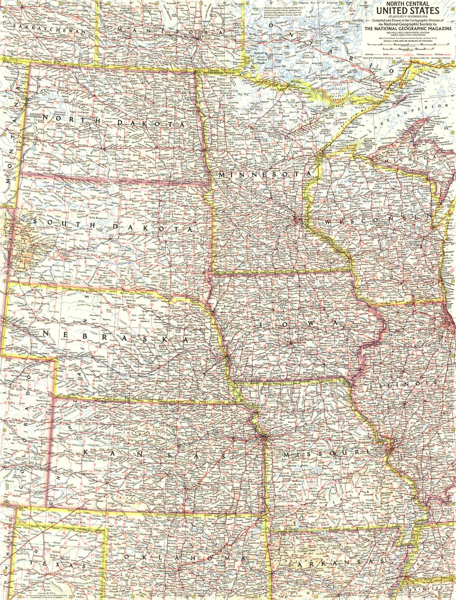
A classic mid-century depiction of America’s interior, North Central United States presents the region with the clarity and balance that define National Geographic cartography. Published in November 1958 to accompany the feature article “The Upper Mississippi,” this map forms part of a six-sheet series documenting the United States during a period of growth and transformation.
From fertile plains to major river systems, it offers a detailed and enduring view of the nation’s heartland.
Why This Map Stands Out
A mid-century cartographic classic
Reflects the style and precision of National Geographic’s golden era.
Part of a six-map U.S. series
One of a coordinated set covering the entire country (1958–1961).
Regional clarity and balance
Combines geography, settlement, and infrastructure.
Historical context
Captures the North Central U.S. during a period of expansion and development.
A refined collector’s piece
Ideal for heritage interiors and map collections.
🗺️ What the Map Shows
- The North Central United States, including:
- North Dakota
- South Dakota
- Minnesota
- Nebraska
- Iowa
- Wisconsin
- Illinois
- Missouri
- Kansas
- Major river systems, including the Upper Mississippi region
- Plains, agricultural zones, and regional landforms
- Cities, towns, and transport routes
- A geographic framework linking land, water, and settlement patterns
📐 Size & Format
631 mm (H) × 480 mm (W)
Portrait orientation
A practical and display-friendly format ideal for:
- Framed historical collections
- Home offices and studies
- Libraries and educational settings
- Interiors with a vintage or Americana theme
✨ Premium Finishes
| Format | Description |
|---|---|
| 📜 Paper (160 gsm) | Heavyweight matte-coated paper—ideal for framing. Preserves fine cartographic detail. |
| 🧼 Laminated (Encapsulated) | Sealed in 2 × 80-micron gloss laminate. Durable and protective for long-term display. |
| 🪵 Laminated + Timber Hang Rails | Laminated map mounted with lacquered natural timber rails and hanging cord—ready to display. |
| 🖼️ Canvas (395 gsm HP Professional Matte) | Printed with archival pigment inks. Adds depth and a refined presentation finish. |
| 🪵 Canvas + Timber Hang Rails | Canvas paired with timber rails for a gallery-style display. |
🔨 Please allow up to 10 working days for professionally mounted hang-railed finishes.
📊 Specifications
| Feature | Detail |
|---|---|
| Title | North Central United States |
| Publisher | National Geographic |
| Published | 1958 |
| Scale | 1:2,851,200 |
| Dimensions | 631 mm × 480 mm |
| Orientation | Landscape |
| Map Type | Historical / Regional |
| Coverage | North Central USA |
| Collections | USA, Historical, Regional |
| Materials | 160 gsm matte paper / 2 × 80-micron laminate / 395 gsm HP Professional Matte Canvas |
| Printing | Pigment-based, fade-resistant inks |
| Origin | Printed in Australia |
🎯 Ideal For
- Collectors of mid-century National Geographic maps
- Enthusiasts of American regional geography
- Students of U.S. development and landscape history
- Interiors seeking a classic, heritage-style display piece
- Gift buyers looking for a timeless and educational map
🌾 The American Heartland in 1958
This region has long been defined by:
- Vast agricultural landscapes and open plains
- River systems shaping transport and settlement
- Growing cities within a largely rural framework
- A landscape central to the nation’s identity and economy
This map captures that moment—offering a clear and compelling view of a region where land, water, and community define the American heartland.
🤝 Our Commitment
- Printed in Australia using archival-quality production
- Faithfully reproduced to preserve original colour and detail
- Premium materials selected for durability and longevity
- Each map is hand-checked before dispatch
- Carefully packaged for safe delivery
🚚 Delivery
- Paper, Laminated, Canvas (rolled): Dispatch within 1–2 business days
- Hang-Railed Maps: Made to order—allow up to 10 working days
- Packaging: Securely rolled in protective tubing
Own a piece of mid-century American cartography—
a map that brings the North Central United States into timeless focus.
👉 Order now and add a classic National Geographic map to your collection.
Original: $50.05
-65%$50.05
$17.52Product Information
Product Information
Shipping & Returns
Shipping & Returns
Description
Historical Regional Map | Upper Mississippi & American Heartland | Wall Format (631 × 480 mm) | Premium Finishes
A classic mid-century depiction of America’s interior, North Central United States presents the region with the clarity and balance that define National Geographic cartography. Published in November 1958 to accompany the feature article “The Upper Mississippi,” this map forms part of a six-sheet series documenting the United States during a period of growth and transformation.
From fertile plains to major river systems, it offers a detailed and enduring view of the nation’s heartland.
Why This Map Stands Out
A mid-century cartographic classic
Reflects the style and precision of National Geographic’s golden era.
Part of a six-map U.S. series
One of a coordinated set covering the entire country (1958–1961).
Regional clarity and balance
Combines geography, settlement, and infrastructure.
Historical context
Captures the North Central U.S. during a period of expansion and development.
A refined collector’s piece
Ideal for heritage interiors and map collections.
🗺️ What the Map Shows
- The North Central United States, including:
- North Dakota
- South Dakota
- Minnesota
- Nebraska
- Iowa
- Wisconsin
- Illinois
- Missouri
- Kansas
- Major river systems, including the Upper Mississippi region
- Plains, agricultural zones, and regional landforms
- Cities, towns, and transport routes
- A geographic framework linking land, water, and settlement patterns
📐 Size & Format
631 mm (H) × 480 mm (W)
Portrait orientation
A practical and display-friendly format ideal for:
- Framed historical collections
- Home offices and studies
- Libraries and educational settings
- Interiors with a vintage or Americana theme
✨ Premium Finishes
| Format | Description |
|---|---|
| 📜 Paper (160 gsm) | Heavyweight matte-coated paper—ideal for framing. Preserves fine cartographic detail. |
| 🧼 Laminated (Encapsulated) | Sealed in 2 × 80-micron gloss laminate. Durable and protective for long-term display. |
| 🪵 Laminated + Timber Hang Rails | Laminated map mounted with lacquered natural timber rails and hanging cord—ready to display. |
| 🖼️ Canvas (395 gsm HP Professional Matte) | Printed with archival pigment inks. Adds depth and a refined presentation finish. |
| 🪵 Canvas + Timber Hang Rails | Canvas paired with timber rails for a gallery-style display. |
🔨 Please allow up to 10 working days for professionally mounted hang-railed finishes.
📊 Specifications
| Feature | Detail |
|---|---|
| Title | North Central United States |
| Publisher | National Geographic |
| Published | 1958 |
| Scale | 1:2,851,200 |
| Dimensions | 631 mm × 480 mm |
| Orientation | Landscape |
| Map Type | Historical / Regional |
| Coverage | North Central USA |
| Collections | USA, Historical, Regional |
| Materials | 160 gsm matte paper / 2 × 80-micron laminate / 395 gsm HP Professional Matte Canvas |
| Printing | Pigment-based, fade-resistant inks |
| Origin | Printed in Australia |
🎯 Ideal For
- Collectors of mid-century National Geographic maps
- Enthusiasts of American regional geography
- Students of U.S. development and landscape history
- Interiors seeking a classic, heritage-style display piece
- Gift buyers looking for a timeless and educational map
🌾 The American Heartland in 1958
This region has long been defined by:
- Vast agricultural landscapes and open plains
- River systems shaping transport and settlement
- Growing cities within a largely rural framework
- A landscape central to the nation’s identity and economy
This map captures that moment—offering a clear and compelling view of a region where land, water, and community define the American heartland.
🤝 Our Commitment
- Printed in Australia using archival-quality production
- Faithfully reproduced to preserve original colour and detail
- Premium materials selected for durability and longevity
- Each map is hand-checked before dispatch
- Carefully packaged for safe delivery
🚚 Delivery
- Paper, Laminated, Canvas (rolled): Dispatch within 1–2 business days
- Hang-Railed Maps: Made to order—allow up to 10 working days
- Packaging: Securely rolled in protective tubing
Own a piece of mid-century American cartography—
a map that brings the North Central United States into timeless focus.
👉 Order now and add a classic National Geographic map to your collection.


