Northeastern United States - Published 1959 by National Geographic
Historical Regional Map | Great Lakes, Transport & Waterways | Wall Format (633 × 480 mm) | Premium Finishes
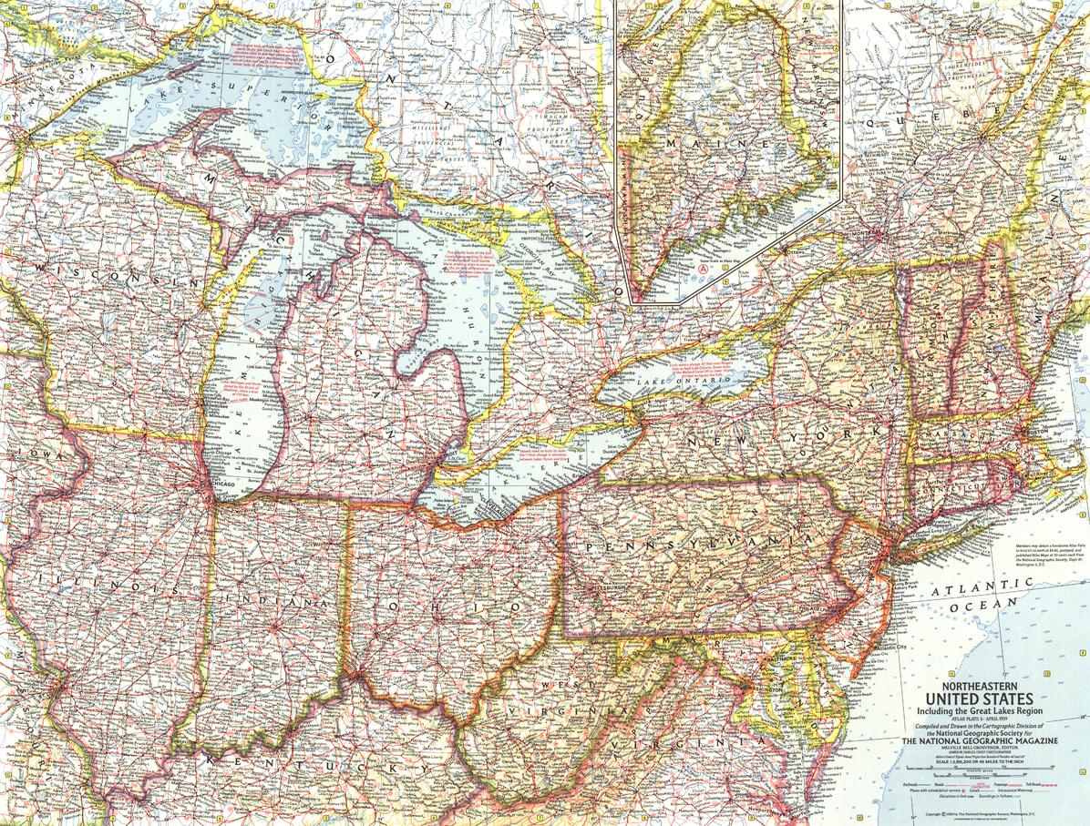
A beautifully detailed mid-century map of America’s industrial and maritime heart, Northeastern United States captures a region defined by waterways, cities, and movement. Published by National Geographic in April 1959 to accompany the feature article “New Era on the Great Lakes,” this map forms part of a six-sheet series documenting the United States during a period of rapid modernisation.
From the inland seas of the Great Lakes to the forests of northern Maine, it offers a precise and engaging view of a region shaped by water, trade, and connection.
Why This Map Stands Out
A Great Lakes focus
Highlights one of the world’s most important freshwater systems.
Mid-century National Geographic style
Clear, elegant cartography from a golden era of mapmaking.
Transport and infrastructure detail
Includes ferry routes, canals, and navigation systems.
Part of a six-map U.S. series
A coordinated set published between 1958 and 1961.
A refined collector’s piece
Ideal for heritage interiors and map collections.
🗺️ What the Map Shows
- The Northeastern United States and Great Lakes region
- Major lakes including Lake Superior, Lake Michigan, Lake Huron, Lake Erie, and Lake Ontario
- Waterway systems including locks, canals, and shipping routes
- Auto ferry routes connecting key points across the lakes
- An inset map of Maine (northern region)
- Cities, towns, and transport networks
- Notes on Great Lakes water levels and navigation systems
📐 Size & Format
633 mm (W) × 480 mm (H)
Landscape orientation
A practical and display-friendly format ideal for:
- Framed historical collections
- Home offices and studies
- Libraries and educational settings
- Interiors with a maritime or industrial theme
✨ Premium Finishes
| Format | Description |
|---|---|
| 📜 Paper (160 gsm) | Heavyweight matte-coated paper—ideal for framing. Preserves fine cartographic detail. |
| 🧼 Laminated (Encapsulated) | Sealed in 2 × 80-micron gloss laminate. Durable and protective for long-term display. |
| 🪵 Laminated + Timber Hang Rails | Laminated map mounted with lacquered natural timber rails and hanging cord—ready to display. |
| 🖼️ Canvas (395 gsm HP Professional Matte) | Printed with archival pigment inks. Adds depth and a refined presentation finish. |
| 🪵 Canvas + Timber Hang Rails | Canvas paired with timber rails for a gallery-style display. |
🔨 Please allow up to 10 working days for professionally mounted hang-railed finishes.
📊 Specifications
| Feature | Detail |
|---|---|
| Title | Northeastern United States |
| Publisher | National Geographic |
| Published | 1959 |
| Scale | 1:2,851,200 |
| Dimensions | 633 mm × 480 mm |
| Orientation | Landscape |
| Map Type | Historical / Regional |
| Coverage | Northeastern USA & Great Lakes Region |
| Collections | USA, Historical, Regional |
| Materials | 160 gsm matte paper / 2 × 80-micron laminate / 395 gsm HP Professional Matte Canvas |
| Printing | Pigment-based, fade-resistant inks |
| Origin | Printed in Australia |
🎯 Ideal For
- Collectors of mid-century National Geographic maps
- Enthusiasts of Great Lakes and U.S. regional geography
- Students of transport, waterways, and industrial history
- Interiors seeking a classic, maritime-inspired display piece
- Gift buyers looking for a timeless and educational map
🌊 A Region Shaped by Water
The Northeastern United States has long been defined by:
- The vast inland seas of the Great Lakes
- Shipping routes connecting the heartland to the Atlantic
- Cities built on trade, industry, and access to water
- Infrastructure that reshaped movement and commerce
This map captures that moment—offering a clear and compelling view of a region where waterways and industry shaped a modern nation.
🤝 Our Commitment
- Printed in Australia using archival-quality production
- Faithfully reproduced to preserve original colour and detail
- Premium materials selected for durability and longevity
- Each map is hand-checked before dispatch
- Carefully packaged for safe delivery
🚚 Delivery
- Paper, Laminated, Canvas (rolled): Dispatch within 1–2 business days
- Hang-Railed Maps: Made to order—allow up to 10 working days
- Packaging: Securely rolled in protective tubing
Own a piece of America’s industrial and maritime story—
a map that brings the Northeastern United States into timeless focus.
👉 Order now and complete your mid-century U.S. map series.
Original: $50.05
-65%$50.05
$17.52Product Information
Product Information
Shipping & Returns
Shipping & Returns
Description
Historical Regional Map | Great Lakes, Transport & Waterways | Wall Format (633 × 480 mm) | Premium Finishes
A beautifully detailed mid-century map of America’s industrial and maritime heart, Northeastern United States captures a region defined by waterways, cities, and movement. Published by National Geographic in April 1959 to accompany the feature article “New Era on the Great Lakes,” this map forms part of a six-sheet series documenting the United States during a period of rapid modernisation.
From the inland seas of the Great Lakes to the forests of northern Maine, it offers a precise and engaging view of a region shaped by water, trade, and connection.
Why This Map Stands Out
A Great Lakes focus
Highlights one of the world’s most important freshwater systems.
Mid-century National Geographic style
Clear, elegant cartography from a golden era of mapmaking.
Transport and infrastructure detail
Includes ferry routes, canals, and navigation systems.
Part of a six-map U.S. series
A coordinated set published between 1958 and 1961.
A refined collector’s piece
Ideal for heritage interiors and map collections.
🗺️ What the Map Shows
- The Northeastern United States and Great Lakes region
- Major lakes including Lake Superior, Lake Michigan, Lake Huron, Lake Erie, and Lake Ontario
- Waterway systems including locks, canals, and shipping routes
- Auto ferry routes connecting key points across the lakes
- An inset map of Maine (northern region)
- Cities, towns, and transport networks
- Notes on Great Lakes water levels and navigation systems
📐 Size & Format
633 mm (W) × 480 mm (H)
Landscape orientation
A practical and display-friendly format ideal for:
- Framed historical collections
- Home offices and studies
- Libraries and educational settings
- Interiors with a maritime or industrial theme
✨ Premium Finishes
| Format | Description |
|---|---|
| 📜 Paper (160 gsm) | Heavyweight matte-coated paper—ideal for framing. Preserves fine cartographic detail. |
| 🧼 Laminated (Encapsulated) | Sealed in 2 × 80-micron gloss laminate. Durable and protective for long-term display. |
| 🪵 Laminated + Timber Hang Rails | Laminated map mounted with lacquered natural timber rails and hanging cord—ready to display. |
| 🖼️ Canvas (395 gsm HP Professional Matte) | Printed with archival pigment inks. Adds depth and a refined presentation finish. |
| 🪵 Canvas + Timber Hang Rails | Canvas paired with timber rails for a gallery-style display. |
🔨 Please allow up to 10 working days for professionally mounted hang-railed finishes.
📊 Specifications
| Feature | Detail |
|---|---|
| Title | Northeastern United States |
| Publisher | National Geographic |
| Published | 1959 |
| Scale | 1:2,851,200 |
| Dimensions | 633 mm × 480 mm |
| Orientation | Landscape |
| Map Type | Historical / Regional |
| Coverage | Northeastern USA & Great Lakes Region |
| Collections | USA, Historical, Regional |
| Materials | 160 gsm matte paper / 2 × 80-micron laminate / 395 gsm HP Professional Matte Canvas |
| Printing | Pigment-based, fade-resistant inks |
| Origin | Printed in Australia |
🎯 Ideal For
- Collectors of mid-century National Geographic maps
- Enthusiasts of Great Lakes and U.S. regional geography
- Students of transport, waterways, and industrial history
- Interiors seeking a classic, maritime-inspired display piece
- Gift buyers looking for a timeless and educational map
🌊 A Region Shaped by Water
The Northeastern United States has long been defined by:
- The vast inland seas of the Great Lakes
- Shipping routes connecting the heartland to the Atlantic
- Cities built on trade, industry, and access to water
- Infrastructure that reshaped movement and commerce
This map captures that moment—offering a clear and compelling view of a region where waterways and industry shaped a modern nation.
🤝 Our Commitment
- Printed in Australia using archival-quality production
- Faithfully reproduced to preserve original colour and detail
- Premium materials selected for durability and longevity
- Each map is hand-checked before dispatch
- Carefully packaged for safe delivery
🚚 Delivery
- Paper, Laminated, Canvas (rolled): Dispatch within 1–2 business days
- Hang-Railed Maps: Made to order—allow up to 10 working days
- Packaging: Securely rolled in protective tubing
Own a piece of America’s industrial and maritime story—
a map that brings the Northeastern United States into timeless focus.
👉 Order now and complete your mid-century U.S. map series.


