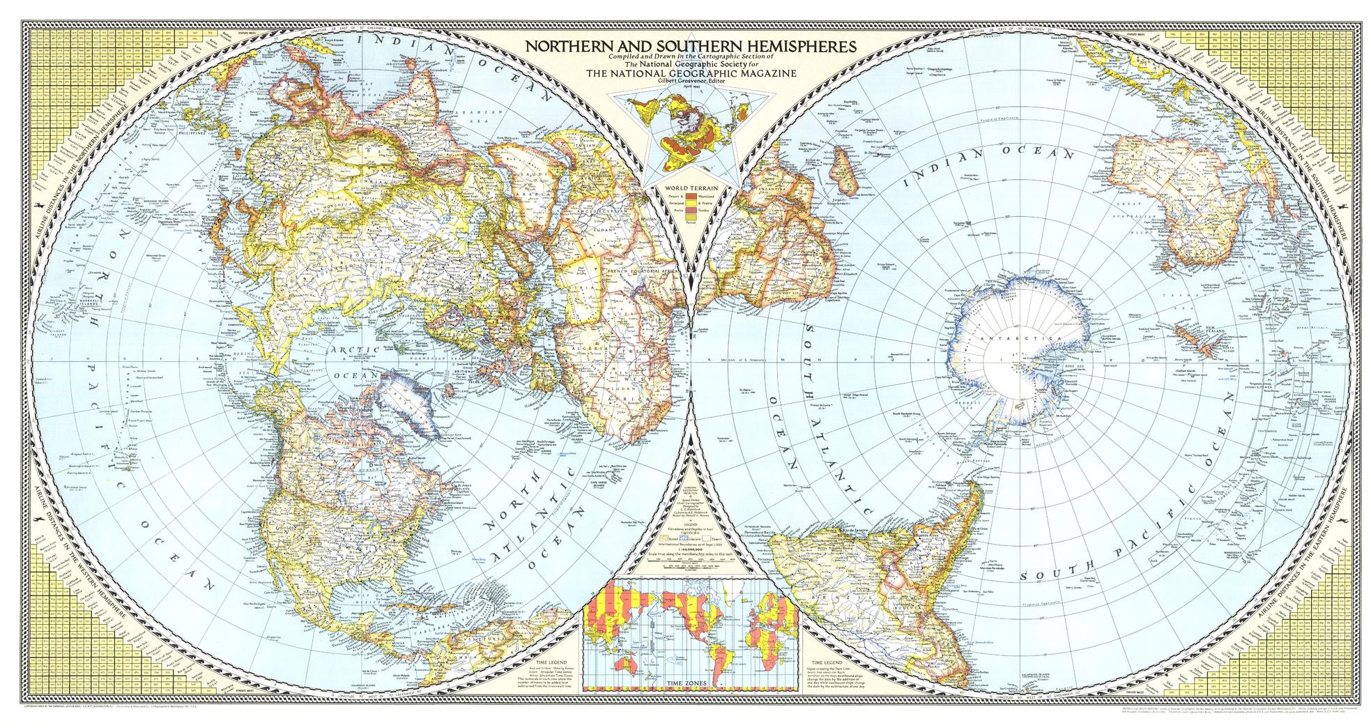
Northern and Southern Hemispheres - Published 1943 by National Geographic
Classic World Wall Map | Polar Perspective & Early Aviation Routes | Large Format (1041 × 552 mm) | Premium Finishes
A striking wartime-era masterpiece, Northern & Southern Hemispheres presents the world in a beautifully balanced dual view—each hemisphere centred on its pole. First published in April 1943 by National Geographic, this map offers a rare and compelling perspective on global geography during a pivotal moment in modern history.
With elegant cartography and innovative design, it reflects both the geographic understanding and emerging global connectivity of the early 20th century.
Why This Map Stands Out
A unique polar perspective
Displays the world as two hemispheres centred on the North and South Poles.
A wartime-era classic
Captures global geography during the 1940s.
Early aviation insights
Includes special insets showing airline distances across the globe.
Elegant, timeless design
A hallmark of National Geographic’s golden age of cartography.
A true collector’s piece
Large, visually striking, and historically significant.
🗺️ What the Map Shows
- Two full hemispheric views of the world:
- Northern Hemisphere centred on the Arctic
- Southern Hemisphere centred on Antarctica
- Continents and oceans presented in a balanced, comparative layout
- Special inset maps illustrating airline distances across:
- Eastern Hemisphere
- Western Hemisphere
- Northern Hemisphere
- Southern Hemisphere
- A global framework highlighting distance, connection, and scale
📐 Size & Format
1041 mm (W) × 552 mm (H)
Landscape orientation (large format)
A bold, statement size ideal for:
- Feature walls and offices
- Libraries and map collections
- Educational and institutional settings
- Interiors with a classic or vintage aesthetic
✨ Premium Finishes
| Format | Description |
|---|---|
| 📜 Paper (160 gsm) | Heavyweight matte-coated paper—ideal for framing. Preserves fine linework and colour. |
| 🧼 Laminated (Encapsulated) | Sealed in 2 × 80-micron gloss laminate. Durable and protective for long-term display. |
| 🪵 Laminated + Timber Hang Rails | Laminated map mounted with lacquered natural timber rails and hanging cord—ready to display. |
| 🖼️ Canvas (395 gsm HP Professional Matte) | Printed with archival pigment inks. Enhances depth and visual presence. |
| 🪵 Canvas + Timber Hang Rails | Canvas paired with timber rails for a refined, gallery-style presentation. |
🔨 Please allow up to 10 working days for professionally mounted hang-railed finishes.
📊 Specifications
| Feature | Detail |
|---|---|
| Title | Northern & Southern Hemispheres |
| Publisher | National Geographic |
| Published | 1943 |
| Dimensions | 1041 mm × 552 mm |
| Orientation | Landscape |
| Map Type | Historical / Political |
| Coverage | World (dual hemispheres) |
| Collections | World, Historical, Political |
| Materials | 160 gsm matte paper / 2 × 80-micron laminate / 395 gsm HP Professional Matte Canvas |
| Printing | Pigment-based, fade-resistant inks |
| Origin | Printed in Australia |
🎯 Ideal For
- Collectors of vintage world maps
- Enthusiasts of historical cartography and aviation history
- Students of global geography and map projections
- Interiors seeking a large, statement display piece
- Gift buyers looking for a timeless and iconic map
🌍 A World Seen Differently
In 1943, the world was being reimagined:
- Air travel was reshaping global distances
- Polar perspectives revealed new geographic relationships
- Cartography reflected both science and global change
- A connected world was beginning to emerge
This map captures that moment—offering a clear and compelling view of a world where distance, perspective, and connection were being redefined.
🤝 Our Commitment
- Printed in Australia using archival-quality production
- Faithfully reproduced to preserve original colour and detail
- Premium materials selected for durability and longevity
- Each map is hand-checked before dispatch
- Carefully packaged for safe delivery
🚚 Delivery
- Paper, Laminated, Canvas (rolled): Dispatch within 1–2 business days
- Hang-Railed Maps: Made to order—allow up to 10 working days
- Packaging: Securely rolled in protective tubing
Own a true cartographic classic—
a map that brings the world’s hemispheres into timeless perspective.
👉 Order now and add a historic global view to your wall.
Original: $64.36
-65%$64.36
$22.53Product Information
Product Information
Shipping & Returns
Shipping & Returns
Description
Classic World Wall Map | Polar Perspective & Early Aviation Routes | Large Format (1041 × 552 mm) | Premium Finishes
A striking wartime-era masterpiece, Northern & Southern Hemispheres presents the world in a beautifully balanced dual view—each hemisphere centred on its pole. First published in April 1943 by National Geographic, this map offers a rare and compelling perspective on global geography during a pivotal moment in modern history.
With elegant cartography and innovative design, it reflects both the geographic understanding and emerging global connectivity of the early 20th century.
Why This Map Stands Out
A unique polar perspective
Displays the world as two hemispheres centred on the North and South Poles.
A wartime-era classic
Captures global geography during the 1940s.
Early aviation insights
Includes special insets showing airline distances across the globe.
Elegant, timeless design
A hallmark of National Geographic’s golden age of cartography.
A true collector’s piece
Large, visually striking, and historically significant.
🗺️ What the Map Shows
- Two full hemispheric views of the world:
- Northern Hemisphere centred on the Arctic
- Southern Hemisphere centred on Antarctica
- Continents and oceans presented in a balanced, comparative layout
- Special inset maps illustrating airline distances across:
- Eastern Hemisphere
- Western Hemisphere
- Northern Hemisphere
- Southern Hemisphere
- A global framework highlighting distance, connection, and scale
📐 Size & Format
1041 mm (W) × 552 mm (H)
Landscape orientation (large format)
A bold, statement size ideal for:
- Feature walls and offices
- Libraries and map collections
- Educational and institutional settings
- Interiors with a classic or vintage aesthetic
✨ Premium Finishes
| Format | Description |
|---|---|
| 📜 Paper (160 gsm) | Heavyweight matte-coated paper—ideal for framing. Preserves fine linework and colour. |
| 🧼 Laminated (Encapsulated) | Sealed in 2 × 80-micron gloss laminate. Durable and protective for long-term display. |
| 🪵 Laminated + Timber Hang Rails | Laminated map mounted with lacquered natural timber rails and hanging cord—ready to display. |
| 🖼️ Canvas (395 gsm HP Professional Matte) | Printed with archival pigment inks. Enhances depth and visual presence. |
| 🪵 Canvas + Timber Hang Rails | Canvas paired with timber rails for a refined, gallery-style presentation. |
🔨 Please allow up to 10 working days for professionally mounted hang-railed finishes.
📊 Specifications
| Feature | Detail |
|---|---|
| Title | Northern & Southern Hemispheres |
| Publisher | National Geographic |
| Published | 1943 |
| Dimensions | 1041 mm × 552 mm |
| Orientation | Landscape |
| Map Type | Historical / Political |
| Coverage | World (dual hemispheres) |
| Collections | World, Historical, Political |
| Materials | 160 gsm matte paper / 2 × 80-micron laminate / 395 gsm HP Professional Matte Canvas |
| Printing | Pigment-based, fade-resistant inks |
| Origin | Printed in Australia |
🎯 Ideal For
- Collectors of vintage world maps
- Enthusiasts of historical cartography and aviation history
- Students of global geography and map projections
- Interiors seeking a large, statement display piece
- Gift buyers looking for a timeless and iconic map
🌍 A World Seen Differently
In 1943, the world was being reimagined:
- Air travel was reshaping global distances
- Polar perspectives revealed new geographic relationships
- Cartography reflected both science and global change
- A connected world was beginning to emerge
This map captures that moment—offering a clear and compelling view of a world where distance, perspective, and connection were being redefined.
🤝 Our Commitment
- Printed in Australia using archival-quality production
- Faithfully reproduced to preserve original colour and detail
- Premium materials selected for durability and longevity
- Each map is hand-checked before dispatch
- Carefully packaged for safe delivery
🚚 Delivery
- Paper, Laminated, Canvas (rolled): Dispatch within 1–2 business days
- Hang-Railed Maps: Made to order—allow up to 10 working days
- Packaging: Securely rolled in protective tubing
Own a true cartographic classic—
a map that brings the world’s hemispheres into timeless perspective.
👉 Order now and add a historic global view to your wall.


