Northern Approaches Maine to the Maritimes - Published 1985 by National Geographic
Making of America Series | Historical & Physical Wall Map | 687 × 518 mm | Premium Finishes
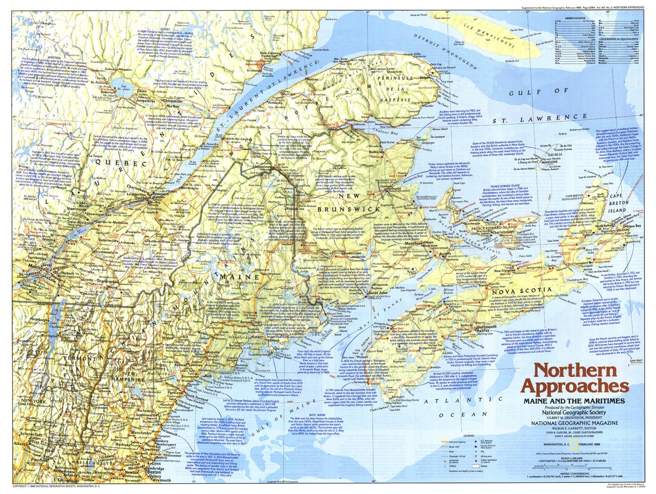
A richly layered view of the North Atlantic frontier, Northern Approaches: Maine to the Maritimes captures a region shaped by sea, settlement, and centuries of cultural exchange. Published by National Geographic in February 1985 as part of the Making of America series, this map blends physical geography with historical narrative across one of North America’s most storied coastlines.
From the rugged shores of Maine to the island provinces of Atlantic Canada, it reveals a maritime world where European traditions and coastal environments intersect.
Why This Map Stands Out
A maritime region in focus
Explores the North Atlantic coastline shaped by trade, fishing, and settlement.
Part of the Making of America series
Combines historical storytelling with precise cartography.
Cultural depth
Highlights the influence of English, French, Scottish, and Dutch settlers.
Physical and historical detail combined
Shows terrain alongside the human story of the region.
A refined wall map
Ideal for both study and display.
🗺️ What the Map Shows
- The Northern Approaches region, including:
- Maine
- New Brunswick
- Nova Scotia
- Prince Edward Island
- Coastal geography, harbours, and maritime routes
- Physical features such as forests, rivers, and shoreline formations
- Towns, settlements, and regional connections
- A historical framework reflecting waves of European settlement
- A regional perspective linking land, sea, and cultural heritage
📐 Size & Format
687 mm (W) × 518 mm (H)
Landscape orientation
A practical format ideal for:
- Classrooms and history education
- Home offices and studies
- Libraries and maritime displays
- Interiors inspired by coastal heritage
✨ Premium Finishes
| Format | Description |
|---|---|
| 📜 Paper (160 gsm) | Heavyweight matte-coated paper—ideal for framing. Preserves clarity and detail. |
| 🧼 Laminated (Encapsulated) | Sealed in 2 × 80-micron gloss laminate. Durable, wipe-clean, and suitable for reference use. |
| 🪵 Laminated + Timber Hang Rails | Laminated map mounted with lacquered natural timber rails and hanging cord—ready to display. |
| 🖼️ Canvas (395 gsm HP Professional Matte) | Printed with archival pigment inks. Enhances depth and colour richness. |
| 🪵 Canvas + Timber Hang Rails | Canvas paired with timber rails for a refined, gallery-style presentation. |
🔨 Please allow up to 10 working days for professionally mounted hang-railed finishes.
📊 Specifications
| Feature | Detail |
|---|---|
| Title | Northern Approaches: Maine to the Maritimes |
| Publisher | National Geographic |
| Published | 1985 |
| Scale | 1:1,735,000 |
| Dimensions | 687 mm × 518 mm |
| Orientation | Landscape |
| Map Type | Historical / Physical |
| Coverage | Northeastern USA & Atlantic Canada |
| Collections | Canada, USA, Historical, Physical |
| Materials | 160 gsm matte paper / 2 × 80-micron laminate / 395 gsm HP Professional Matte Canvas |
| Printing | Pigment-based, fade-resistant inks |
| Origin | Printed in Australia |
🎯 Ideal For
- Students and educators of North American history and geography
- Enthusiasts of maritime culture and coastal regions
- Collectors of National Geographic historical maps
- Interiors seeking a coastal, heritage-inspired display piece
- Gift buyers looking for a distinctive regional map
🌊 A Coastline of Culture and Connection
The Northern Approaches region is defined by:
- Rugged coastlines and seafaring traditions
- Waves of European settlement shaping identity
- Harbours linking communities across the Atlantic
- Landscapes where land and sea are inseparable
This map captures that character—offering a clear and compelling view of a region where history, culture, and coastline meet.
🤝 Our Commitment
- Printed in Australia using archival-quality production
- Faithfully reproduced to preserve clarity and historical detail
- Premium materials selected for durability and longevity
- Each map is hand-checked before dispatch
- Carefully packaged for safe delivery
🚚 Delivery
- Paper, Laminated, Canvas (rolled): Dispatch within 1–2 business days
- Hang-Railed Maps: Made to order—allow up to 10 working days
- Packaging: Securely rolled in protective tubing
Explore the North Atlantic frontier—
a map that brings Maine and the Maritimes into rich historical focus.
👉 Order now and add a timeless coastal perspective to your wall.
Original: $50.05
-65%$50.05
$17.52Product Information
Product Information
Shipping & Returns
Shipping & Returns
Description
Making of America Series | Historical & Physical Wall Map | 687 × 518 mm | Premium Finishes
A richly layered view of the North Atlantic frontier, Northern Approaches: Maine to the Maritimes captures a region shaped by sea, settlement, and centuries of cultural exchange. Published by National Geographic in February 1985 as part of the Making of America series, this map blends physical geography with historical narrative across one of North America’s most storied coastlines.
From the rugged shores of Maine to the island provinces of Atlantic Canada, it reveals a maritime world where European traditions and coastal environments intersect.
Why This Map Stands Out
A maritime region in focus
Explores the North Atlantic coastline shaped by trade, fishing, and settlement.
Part of the Making of America series
Combines historical storytelling with precise cartography.
Cultural depth
Highlights the influence of English, French, Scottish, and Dutch settlers.
Physical and historical detail combined
Shows terrain alongside the human story of the region.
A refined wall map
Ideal for both study and display.
🗺️ What the Map Shows
- The Northern Approaches region, including:
- Maine
- New Brunswick
- Nova Scotia
- Prince Edward Island
- Coastal geography, harbours, and maritime routes
- Physical features such as forests, rivers, and shoreline formations
- Towns, settlements, and regional connections
- A historical framework reflecting waves of European settlement
- A regional perspective linking land, sea, and cultural heritage
📐 Size & Format
687 mm (W) × 518 mm (H)
Landscape orientation
A practical format ideal for:
- Classrooms and history education
- Home offices and studies
- Libraries and maritime displays
- Interiors inspired by coastal heritage
✨ Premium Finishes
| Format | Description |
|---|---|
| 📜 Paper (160 gsm) | Heavyweight matte-coated paper—ideal for framing. Preserves clarity and detail. |
| 🧼 Laminated (Encapsulated) | Sealed in 2 × 80-micron gloss laminate. Durable, wipe-clean, and suitable for reference use. |
| 🪵 Laminated + Timber Hang Rails | Laminated map mounted with lacquered natural timber rails and hanging cord—ready to display. |
| 🖼️ Canvas (395 gsm HP Professional Matte) | Printed with archival pigment inks. Enhances depth and colour richness. |
| 🪵 Canvas + Timber Hang Rails | Canvas paired with timber rails for a refined, gallery-style presentation. |
🔨 Please allow up to 10 working days for professionally mounted hang-railed finishes.
📊 Specifications
| Feature | Detail |
|---|---|
| Title | Northern Approaches: Maine to the Maritimes |
| Publisher | National Geographic |
| Published | 1985 |
| Scale | 1:1,735,000 |
| Dimensions | 687 mm × 518 mm |
| Orientation | Landscape |
| Map Type | Historical / Physical |
| Coverage | Northeastern USA & Atlantic Canada |
| Collections | Canada, USA, Historical, Physical |
| Materials | 160 gsm matte paper / 2 × 80-micron laminate / 395 gsm HP Professional Matte Canvas |
| Printing | Pigment-based, fade-resistant inks |
| Origin | Printed in Australia |
🎯 Ideal For
- Students and educators of North American history and geography
- Enthusiasts of maritime culture and coastal regions
- Collectors of National Geographic historical maps
- Interiors seeking a coastal, heritage-inspired display piece
- Gift buyers looking for a distinctive regional map
🌊 A Coastline of Culture and Connection
The Northern Approaches region is defined by:
- Rugged coastlines and seafaring traditions
- Waves of European settlement shaping identity
- Harbours linking communities across the Atlantic
- Landscapes where land and sea are inseparable
This map captures that character—offering a clear and compelling view of a region where history, culture, and coastline meet.
🤝 Our Commitment
- Printed in Australia using archival-quality production
- Faithfully reproduced to preserve clarity and historical detail
- Premium materials selected for durability and longevity
- Each map is hand-checked before dispatch
- Carefully packaged for safe delivery
🚚 Delivery
- Paper, Laminated, Canvas (rolled): Dispatch within 1–2 business days
- Hang-Railed Maps: Made to order—allow up to 10 working days
- Packaging: Securely rolled in protective tubing
Explore the North Atlantic frontier—
a map that brings Maine and the Maritimes into rich historical focus.
👉 Order now and add a timeless coastal perspective to your wall.


