Northern Plains Map Side 1 - Published 1986 by National Geographic
Making of America Series | Historical Regional Wall Map | 686 × 518 mm | Premium Finishes
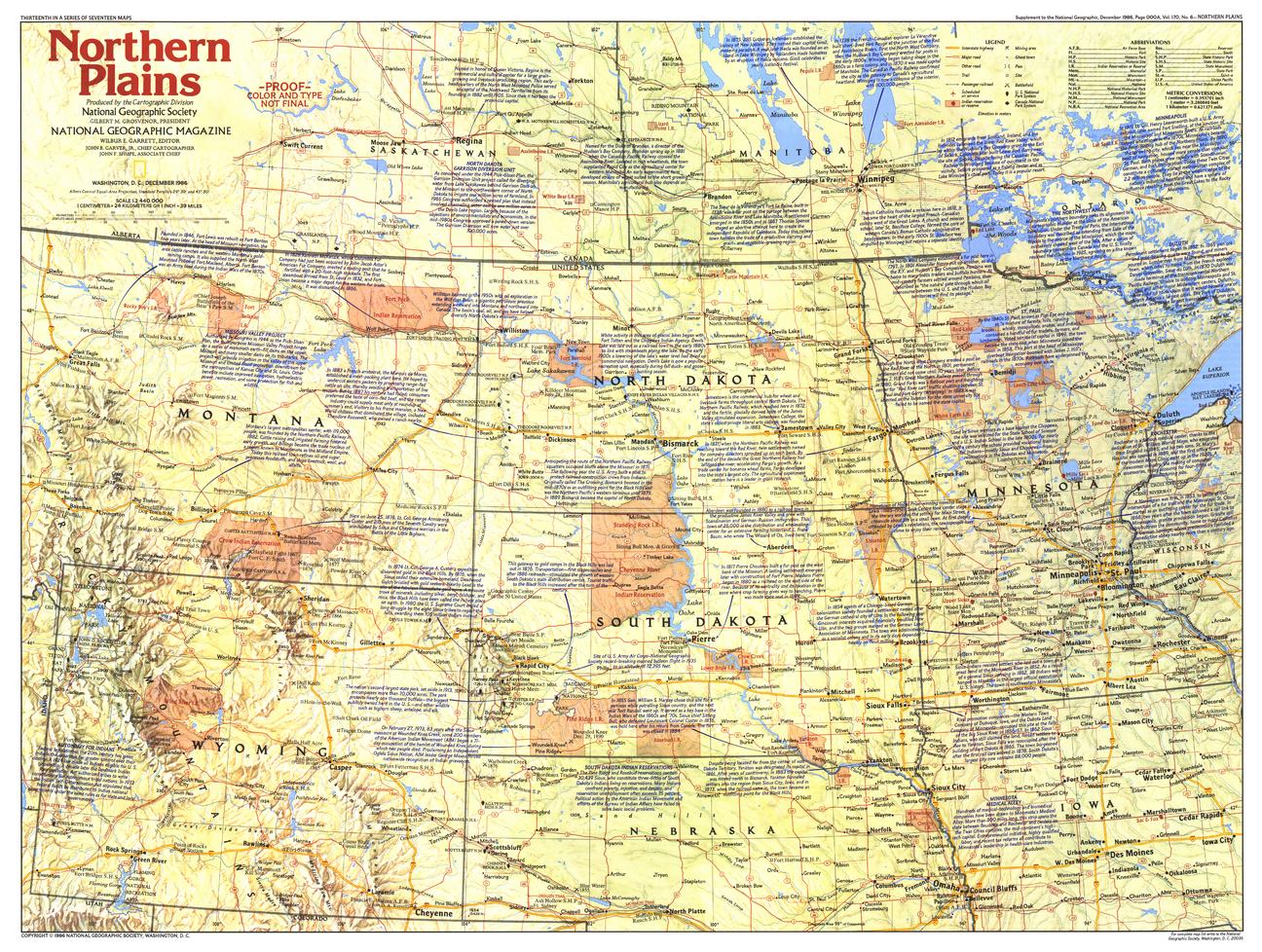
A landscape steeped in legend and turning points, Northern Plains — Side 1 brings the history of America’s interior vividly into focus. Published by National Geographic in December 1986 as part of the Making of America series, this map combines geography, narrative, and historic sites across the vast plains of the United States.
Issued alongside the feature article “Ghosts on the Little Bighorn,” it offers a compelling view of a region where frontier expansion, conflict, and nation-building unfolded.
Why This Map Stands Out
A story-rich landscape
Blends geography with key historical events and locations.
Part of the Making of America series
Combines cartography with narrative storytelling.
Landmarks of national history
Highlights iconic sites and routes of westward expansion.
Educational and engaging
Ideal for understanding the historical development of the Plains.
A refined wall map
Perfect for both display and study.
🗺️ What the Map Shows
- The Northern Plains region of the United States
- Key historical sites, including:
- Battle of Little Bighorn site
- Routes of the Oregon Trail and Mormon Trail
- Mount Rushmore
- Towns, landmarks, and points of interest across the plains
- Historical notes providing context and interpretation
- A regional framework linking land, movement, and history
📐 Size & Format
686 mm (W) × 518 mm (H)
Landscape orientation
A practical format ideal for:
- Classrooms and history education
- Home offices and studies
- Libraries and heritage displays
- Interiors inspired by American history
✨ Premium Finishes
| Format | Description |
|---|---|
| 📜 Paper (160 gsm) | Heavyweight matte-coated paper—ideal for framing. Preserves fine detail and text clarity. |
| 🧼 Laminated (Encapsulated) | Sealed in 2 × 80-micron gloss laminate. Durable and suitable for frequent reference. |
| 🪵 Laminated + Timber Hang Rails | Laminated map mounted with lacquered natural timber rails and hanging cord—ready to display. |
| 🖼️ Canvas (395 gsm HP Professional Matte) | Printed with archival pigment inks. Enhances depth and presentation. |
| 🪵 Canvas + Timber Hang Rails | Canvas paired with timber rails for a refined, gallery-style finish. |
🔨 Please allow up to 10 working days for professionally mounted hang-railed finishes.
📊 Specifications
| Feature | Detail |
|---|---|
| Title | Northern Plains — Side 1 |
| Publisher | National Geographic |
| Published | 1986 |
| Scale | 1:2,440,000 |
| Dimensions | 686 mm × 518 mm |
| Orientation | Landscape |
| Map Type | Historical / Regional |
| Coverage | Northern Plains, USA |
| Collections | USA, Historical, Regional |
| Materials | 160 gsm matte paper / 2 × 80-micron laminate / 395 gsm HP Professional Matte Canvas |
| Printing | Pigment-based, fade-resistant inks |
| Origin | Printed in Australia |
🎯 Ideal For
- Students and educators of American history and westward expansion
- Collectors of National Geographic historical maps
- Enthusiasts of frontier history and the Plains region
- Interiors seeking a heritage-inspired display piece
- Gift buyers looking for a meaningful historical map
🌾 Where History Crossed the Plains
The Northern Plains were a stage for:
- Migration and expansion across vast open landscapes
- Encounters and conflicts that shaped a nation
- Routes that carried settlers westward
- Landmarks that still define American identity
This map captures that story—offering a clear and compelling view of a region where history is written across the land itself.
🤝 Our Commitment
- Printed in Australia using archival-quality production
- Faithfully reproduced to preserve clarity and historical detail
- Premium materials selected for durability and longevity
- Each map is hand-checked before dispatch
- Carefully packaged for safe delivery
🚚 Delivery
- Paper, Laminated, Canvas (rolled): Dispatch within 1–2 business days
- Hang-Railed Maps: Made to order—allow up to 10 working days
- Packaging: Securely rolled in protective tubing
Step into the story of the American frontier—
a map that brings the Northern Plains into sharp historical focus.
👉 Order now and add a classic to your collection.
Original: $50.05
-65%$50.05
$17.52Product Information
Product Information
Shipping & Returns
Shipping & Returns
Description
Making of America Series | Historical Regional Wall Map | 686 × 518 mm | Premium Finishes
A landscape steeped in legend and turning points, Northern Plains — Side 1 brings the history of America’s interior vividly into focus. Published by National Geographic in December 1986 as part of the Making of America series, this map combines geography, narrative, and historic sites across the vast plains of the United States.
Issued alongside the feature article “Ghosts on the Little Bighorn,” it offers a compelling view of a region where frontier expansion, conflict, and nation-building unfolded.
Why This Map Stands Out
A story-rich landscape
Blends geography with key historical events and locations.
Part of the Making of America series
Combines cartography with narrative storytelling.
Landmarks of national history
Highlights iconic sites and routes of westward expansion.
Educational and engaging
Ideal for understanding the historical development of the Plains.
A refined wall map
Perfect for both display and study.
🗺️ What the Map Shows
- The Northern Plains region of the United States
- Key historical sites, including:
- Battle of Little Bighorn site
- Routes of the Oregon Trail and Mormon Trail
- Mount Rushmore
- Towns, landmarks, and points of interest across the plains
- Historical notes providing context and interpretation
- A regional framework linking land, movement, and history
📐 Size & Format
686 mm (W) × 518 mm (H)
Landscape orientation
A practical format ideal for:
- Classrooms and history education
- Home offices and studies
- Libraries and heritage displays
- Interiors inspired by American history
✨ Premium Finishes
| Format | Description |
|---|---|
| 📜 Paper (160 gsm) | Heavyweight matte-coated paper—ideal for framing. Preserves fine detail and text clarity. |
| 🧼 Laminated (Encapsulated) | Sealed in 2 × 80-micron gloss laminate. Durable and suitable for frequent reference. |
| 🪵 Laminated + Timber Hang Rails | Laminated map mounted with lacquered natural timber rails and hanging cord—ready to display. |
| 🖼️ Canvas (395 gsm HP Professional Matte) | Printed with archival pigment inks. Enhances depth and presentation. |
| 🪵 Canvas + Timber Hang Rails | Canvas paired with timber rails for a refined, gallery-style finish. |
🔨 Please allow up to 10 working days for professionally mounted hang-railed finishes.
📊 Specifications
| Feature | Detail |
|---|---|
| Title | Northern Plains — Side 1 |
| Publisher | National Geographic |
| Published | 1986 |
| Scale | 1:2,440,000 |
| Dimensions | 686 mm × 518 mm |
| Orientation | Landscape |
| Map Type | Historical / Regional |
| Coverage | Northern Plains, USA |
| Collections | USA, Historical, Regional |
| Materials | 160 gsm matte paper / 2 × 80-micron laminate / 395 gsm HP Professional Matte Canvas |
| Printing | Pigment-based, fade-resistant inks |
| Origin | Printed in Australia |
🎯 Ideal For
- Students and educators of American history and westward expansion
- Collectors of National Geographic historical maps
- Enthusiasts of frontier history and the Plains region
- Interiors seeking a heritage-inspired display piece
- Gift buyers looking for a meaningful historical map
🌾 Where History Crossed the Plains
The Northern Plains were a stage for:
- Migration and expansion across vast open landscapes
- Encounters and conflicts that shaped a nation
- Routes that carried settlers westward
- Landmarks that still define American identity
This map captures that story—offering a clear and compelling view of a region where history is written across the land itself.
🤝 Our Commitment
- Printed in Australia using archival-quality production
- Faithfully reproduced to preserve clarity and historical detail
- Premium materials selected for durability and longevity
- Each map is hand-checked before dispatch
- Carefully packaged for safe delivery
🚚 Delivery
- Paper, Laminated, Canvas (rolled): Dispatch within 1–2 business days
- Hang-Railed Maps: Made to order—allow up to 10 working days
- Packaging: Securely rolled in protective tubing
Step into the story of the American frontier—
a map that brings the Northern Plains into sharp historical focus.
👉 Order now and add a classic to your collection.


