Northern Plains Map Side 2 - Published 1986 by National Geographic
Making of America Series | Transformation of the Plains | Historical Thematic Wall Map | 686 × 518 mm | Premium Finishes
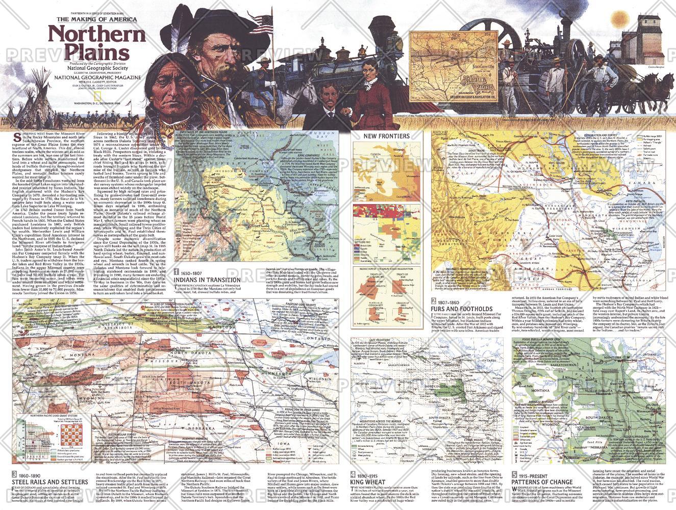
A powerful continuation of the Northern Plains story, Side 2 moves beyond place and into process—revealing how one of North America’s great landscapes was transformed over time. Published by National Geographic in December 1986 as part of the Making of America series, this map uses layered cartography and thematic analysis to trace the evolution of the Plains from Indigenous homelands to a modern economic powerhouse.
Where Side 1 grounds you in geography and historic sites, this companion sheet explains what changed, how it changed, and why it matters.
Why This Map Stands Out
A story of transformation at scale
Tracks the profound shift from natural ecosystems to industrial landscapes.
Multi-layered cartography
Uses a series of inset maps to show change across different time periods.
Economic and environmental insight
Explores how land use evolved into agriculture, energy, and industry.
A true companion piece
Designed to pair with Side 1 for a complete regional narrative.
A deeper, analytical map
Perfect for those who want more than just location—this is about understanding change.
🗺️ What the Map Shows
- The Northern Plains across multiple historical phases
- Original buffalo ranges and Indigenous hunting grounds
- Gradual transition to settlement and agricultural development
- Expansion of key industries, including:
- Broadacre farming and ranching
- Petroleum extraction and energy corridors
- Mining regions and mineral resources
- Manufacturing and regional economic hubs
- A sequence of inset maps illustrating:
- Land use over time
- Population and settlement expansion
- Resource exploitation and infrastructure growth
- A cohesive framework linking landscape, resources, and human activity
🌾 From Open Range to Economic Engine
This map captures one of the most significant transformations in North American history:
- Pre-contact landscapes dominated by wildlife and Indigenous stewardship
- Frontier expansion reshaping land ownership and use
- Railways and settlement opening vast areas to agriculture
- Modern industries redefining the Plains as a centre for food and energy production
It’s a visual narrative of how a region evolves when natural systems meet human ambition.
📐 Size & Format
686 mm (W) × 518 mm (H)
Landscape orientation
A balanced, display-ready format ideal for:
- Classrooms and tertiary education
- Offices and planning environments
- Home libraries and study walls
- Pairing with Side 1 as a complete two-map set
✨ Premium Finishes
| Format | Description |
|---|---|
| 📜 Heavyweight Paper (160 gsm matte) | Archival-quality, low-glare finish—ideal for framing under glass. |
| 🧼 Laminated (True Encapsulation) | 2 × 80-micron gloss laminate, edge-sealed. Durable, wipe-clean, and perfect for annotation. |
| 🪵 Laminated + Timber Hang Rails | Ready-to-hang with lacquered natural timber rails and cord. Allow up to 10 working days. |
| 🖼️ Archival Canvas (395 gsm HP Professional Matte) | Museum-grade finish with pigment-based, fade-resistant inks. |
| 🪵 Canvas + Timber Hang Rails | Gallery-ready canvas with timber rails. Allow up to 10 working days. |
📊 Specifications
| Feature | Detail |
|---|---|
| Title | Northern Plains — Side 2 |
| Publisher | National Geographic |
| Published | 1986 |
| Series | Making of America |
| Dimensions | 686 mm × 518 mm |
| Orientation | Landscape |
| Map Type | Historical / Thematic |
| Coverage | Northern Plains, USA |
| Collections | North America, Historical |
| Materials | 160 gsm matte paper · 2 × 80-micron laminate · 395 gsm HP Professional Matte Canvas |
| Inks | Pigment-based, fade-resistant |
| Origin | Printed in Australia |
🎯 Ideal For
- Students and educators exploring land use, history, and economics
- Collectors building a complete Making of America series
- Professionals in planning, agriculture, or resource industries
- Interiors seeking a thought-provoking, narrative-driven map
- Gift buyers wanting something intellectual, visual, and meaningful
🧭 A Map About Change
Unlike traditional maps that show where, this map shows how and why:
- How landscapes evolve
- How economies emerge
- How cultures and industries reshape regions
- How history leaves its mark on the land
It’s not just a map of the Northern Plains—it’s a timeline, an analysis, and a story told through cartography.
🤝 Our Commitment
- Printed in Australia using archival-quality materials
- Faithfully reproduced to preserve clarity, colour, and detail
- Premium finishes designed for long-term display
- Each map is hand-checked and carefully packed
🚚 Delivery
- Rolled (Paper, Laminated, Canvas): Dispatch within 1–2 business days
- Hang-Railed Finishes: Made to order — allow up to 10 working days
Complete the story of the Plains—
pair Side 2 with Side 1 to experience the full transformation of a region shaped by land, people, and time.
Original: $50.05
-65%$50.05
$17.52Product Information
Product Information
Shipping & Returns
Shipping & Returns
Description
Making of America Series | Transformation of the Plains | Historical Thematic Wall Map | 686 × 518 mm | Premium Finishes
A powerful continuation of the Northern Plains story, Side 2 moves beyond place and into process—revealing how one of North America’s great landscapes was transformed over time. Published by National Geographic in December 1986 as part of the Making of America series, this map uses layered cartography and thematic analysis to trace the evolution of the Plains from Indigenous homelands to a modern economic powerhouse.
Where Side 1 grounds you in geography and historic sites, this companion sheet explains what changed, how it changed, and why it matters.
Why This Map Stands Out
A story of transformation at scale
Tracks the profound shift from natural ecosystems to industrial landscapes.
Multi-layered cartography
Uses a series of inset maps to show change across different time periods.
Economic and environmental insight
Explores how land use evolved into agriculture, energy, and industry.
A true companion piece
Designed to pair with Side 1 for a complete regional narrative.
A deeper, analytical map
Perfect for those who want more than just location—this is about understanding change.
🗺️ What the Map Shows
- The Northern Plains across multiple historical phases
- Original buffalo ranges and Indigenous hunting grounds
- Gradual transition to settlement and agricultural development
- Expansion of key industries, including:
- Broadacre farming and ranching
- Petroleum extraction and energy corridors
- Mining regions and mineral resources
- Manufacturing and regional economic hubs
- A sequence of inset maps illustrating:
- Land use over time
- Population and settlement expansion
- Resource exploitation and infrastructure growth
- A cohesive framework linking landscape, resources, and human activity
🌾 From Open Range to Economic Engine
This map captures one of the most significant transformations in North American history:
- Pre-contact landscapes dominated by wildlife and Indigenous stewardship
- Frontier expansion reshaping land ownership and use
- Railways and settlement opening vast areas to agriculture
- Modern industries redefining the Plains as a centre for food and energy production
It’s a visual narrative of how a region evolves when natural systems meet human ambition.
📐 Size & Format
686 mm (W) × 518 mm (H)
Landscape orientation
A balanced, display-ready format ideal for:
- Classrooms and tertiary education
- Offices and planning environments
- Home libraries and study walls
- Pairing with Side 1 as a complete two-map set
✨ Premium Finishes
| Format | Description |
|---|---|
| 📜 Heavyweight Paper (160 gsm matte) | Archival-quality, low-glare finish—ideal for framing under glass. |
| 🧼 Laminated (True Encapsulation) | 2 × 80-micron gloss laminate, edge-sealed. Durable, wipe-clean, and perfect for annotation. |
| 🪵 Laminated + Timber Hang Rails | Ready-to-hang with lacquered natural timber rails and cord. Allow up to 10 working days. |
| 🖼️ Archival Canvas (395 gsm HP Professional Matte) | Museum-grade finish with pigment-based, fade-resistant inks. |
| 🪵 Canvas + Timber Hang Rails | Gallery-ready canvas with timber rails. Allow up to 10 working days. |
📊 Specifications
| Feature | Detail |
|---|---|
| Title | Northern Plains — Side 2 |
| Publisher | National Geographic |
| Published | 1986 |
| Series | Making of America |
| Dimensions | 686 mm × 518 mm |
| Orientation | Landscape |
| Map Type | Historical / Thematic |
| Coverage | Northern Plains, USA |
| Collections | North America, Historical |
| Materials | 160 gsm matte paper · 2 × 80-micron laminate · 395 gsm HP Professional Matte Canvas |
| Inks | Pigment-based, fade-resistant |
| Origin | Printed in Australia |
🎯 Ideal For
- Students and educators exploring land use, history, and economics
- Collectors building a complete Making of America series
- Professionals in planning, agriculture, or resource industries
- Interiors seeking a thought-provoking, narrative-driven map
- Gift buyers wanting something intellectual, visual, and meaningful
🧭 A Map About Change
Unlike traditional maps that show where, this map shows how and why:
- How landscapes evolve
- How economies emerge
- How cultures and industries reshape regions
- How history leaves its mark on the land
It’s not just a map of the Northern Plains—it’s a timeline, an analysis, and a story told through cartography.
🤝 Our Commitment
- Printed in Australia using archival-quality materials
- Faithfully reproduced to preserve clarity, colour, and detail
- Premium finishes designed for long-term display
- Each map is hand-checked and carefully packed
🚚 Delivery
- Rolled (Paper, Laminated, Canvas): Dispatch within 1–2 business days
- Hang-Railed Finishes: Made to order — allow up to 10 working days
Complete the story of the Plains—
pair Side 2 with Side 1 to experience the full transformation of a region shaped by land, people, and time.


