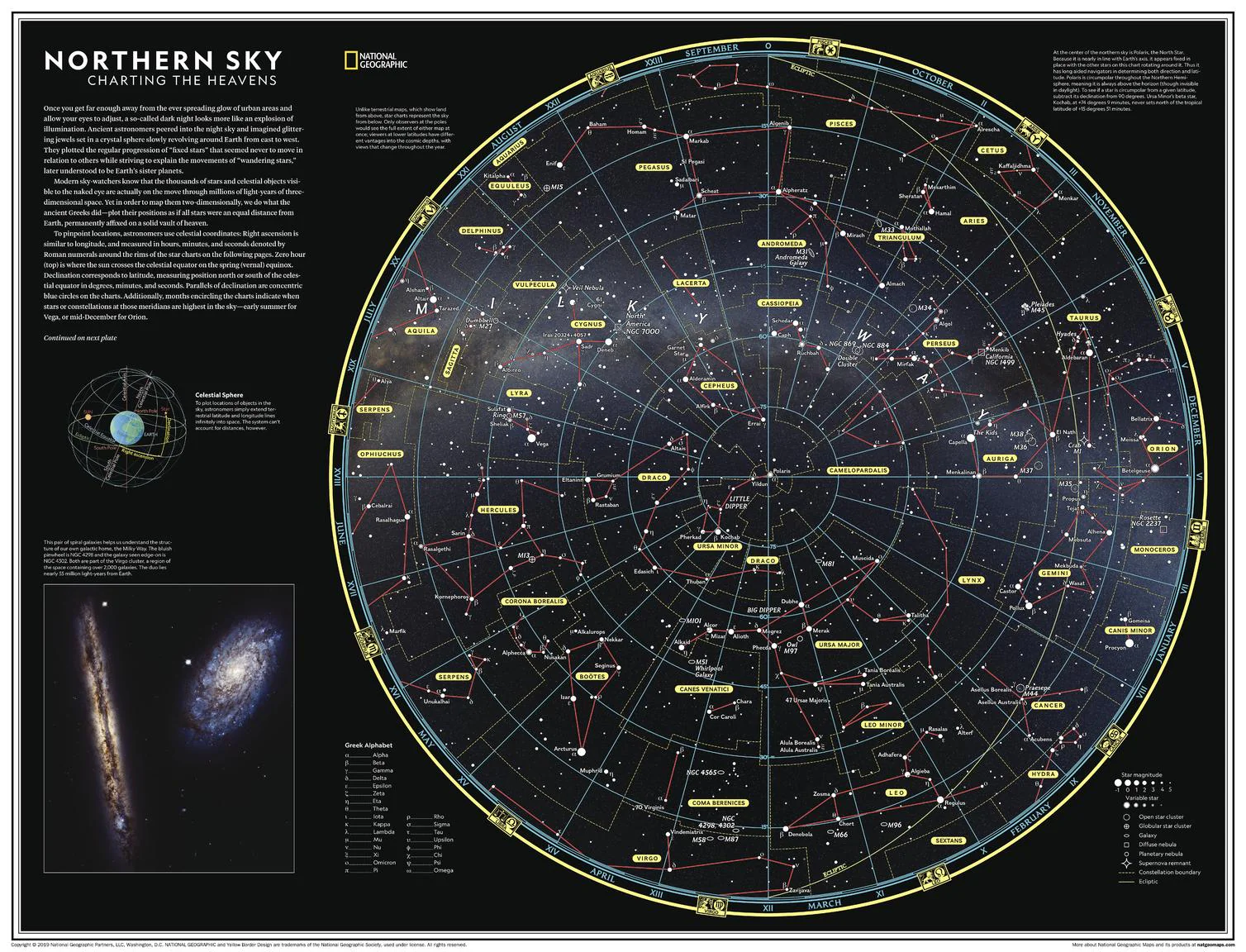
Northern Sky: Charting the Heavens - Atlas of the World, 11th Edition
Atlas of the World (11th Edition) | Celestial Wall Map | Constellations & Deep Sky Objects | 798 × 610 mm | Premium Finishes
Step beyond the glow of city lights and into a sky alive with detail. Northern Sky: Charting the Heavens captures the night as seen from the Northern Hemisphere—where stars, constellations, and distant galaxies form a map as rich and structured as any on Earth. Published by National Geographic as part of the Atlas of the World, 11th Edition, this map blends astronomy, history, and elegant design into a striking celestial reference.
It’s a map for those who look up—and want to understand what they see.
Why This Map Stands Out
A complete map of the northern sky
Features all 88 constellations recognised by the International Astronomical Union.
Scientific and visual clarity
Combines precise star data with a clean, readable layout.
Rooted in ancient observation
Reflects the long tradition of cultures mapping stories onto the stars.
Perfect companion piece
Pairs with Southern Sky: Charting the Heavens for a full celestial view.
A striking wall display
Equally suited to study, teaching, or gallery-style presentation.
🌌 What the Map Shows
- The night sky as viewed from the Northern Hemisphere
- All 88 officially recognised constellations, including their boundaries
- Major stars labelled using traditional Greek-letter designations:
- Alpha (brightest), Beta (second brightest), and so on
- Deep-sky objects, including:
- Galaxies, nebulae, and star clusters
- Identified using Messier (M) and New General Catalogue (NGC) numbers
- A structured celestial grid dividing the sky into mapped regions
- A framework linking astronomy, navigation, and cultural storytelling
✨ A Sky of Stories and Science
For millennia, humans have looked upward:
- Ancient astronomers imagined stars as jewels set in a rotating sphere
- Cultures across the world created constellations from myth and memory
- Modern astronomy transformed these patterns into measurable systems
- Today, the sky is both a map of imagination and a catalogue of the universe
This map captures that duality—where science meets wonder.
📐 Size & Format
798 mm (H) × 610 mm (W)
Portrait orientation
Ideal for:
- Classrooms and STEM education
- Home offices and study walls
- Astronomy enthusiasts and hobbyists
- Gallery-style interiors and feature walls
✨ Premium Finishes
| Format | Description |
|---|---|
| 📜 Paper (160 gsm) | Heavyweight matte-coated paper—ideal for framing. Crisp detail with low glare. |
| 🧼 Laminated (True Encapsulation) | 2 × 80-micron gloss laminate. Durable, wipe-clean, and great for reference use. |
| 🪵 Laminated + Timber Hang Rails | Ready-to-hang with lacquered natural timber rails. Allow up to 10 working days. |
| 🖼️ Archival Canvas (395 gsm HP Professional Matte) | Museum-grade finish with pigment-based, fade-resistant inks. |
| 🪵 Canvas + Timber Hang Rails | Gallery-ready presentation. Allow up to 10 working days. |
📊 Specifications
| Feature | Detail |
|---|---|
| Title | Northern Sky: Charting the Heavens |
| Publisher | National Geographic |
| Published | 2019 |
| Atlas | Atlas of the World, 11th Edition (Plate 121) |
| Dimensions | 798 mm × 610 mm |
| Orientation | Portrait |
| Map Type | Celestial / Thematic |
| Coverage | Northern Hemisphere Sky |
| Collections | Space, Thematic |
| Materials | 160 gsm matte paper · 2 × 80-micron laminate · 395 gsm HP Professional Matte Canvas |
| Inks | Pigment-based, fade-resistant |
| Origin | Printed in Australia |
🎯 Ideal For
- Stargazers and amateur astronomers
- Students and educators in astronomy and science
- Collectors of National Geographic thematic maps
- Interiors seeking a unique and contemplative display piece
- Gift buyers looking for a beautiful and educational map
🌠 Chart the Night
Away from city lights, the sky reveals:
- Constellations that have guided travellers for centuries
- Galaxies and nebulae stretching far beyond our own
- A structured universe mapped with precision
- A timeless connection between humanity and the cosmos
This map brings that experience indoors—offering a clear and inspiring view of the heavens above.
🤝 Our Commitment
- Printed in Australia using archival-quality materials
- Faithfully reproduced for maximum clarity and precision
- Premium finishes designed for long-term display
- Each map is hand-checked and carefully packed
🚚 Delivery
- Rolled (Paper, Laminated, Canvas): Dispatch within 1–2 business days
- Hang-Railed Finishes: Made to order — allow up to 10 working days
Look up—and understand what you see.
A map that brings the northern night sky into brilliant focus. ✨
Original: $50.05
-65%$50.05
$17.52Product Information
Product Information
Shipping & Returns
Shipping & Returns
Description
Atlas of the World (11th Edition) | Celestial Wall Map | Constellations & Deep Sky Objects | 798 × 610 mm | Premium Finishes
Step beyond the glow of city lights and into a sky alive with detail. Northern Sky: Charting the Heavens captures the night as seen from the Northern Hemisphere—where stars, constellations, and distant galaxies form a map as rich and structured as any on Earth. Published by National Geographic as part of the Atlas of the World, 11th Edition, this map blends astronomy, history, and elegant design into a striking celestial reference.
It’s a map for those who look up—and want to understand what they see.
Why This Map Stands Out
A complete map of the northern sky
Features all 88 constellations recognised by the International Astronomical Union.
Scientific and visual clarity
Combines precise star data with a clean, readable layout.
Rooted in ancient observation
Reflects the long tradition of cultures mapping stories onto the stars.
Perfect companion piece
Pairs with Southern Sky: Charting the Heavens for a full celestial view.
A striking wall display
Equally suited to study, teaching, or gallery-style presentation.
🌌 What the Map Shows
- The night sky as viewed from the Northern Hemisphere
- All 88 officially recognised constellations, including their boundaries
- Major stars labelled using traditional Greek-letter designations:
- Alpha (brightest), Beta (second brightest), and so on
- Deep-sky objects, including:
- Galaxies, nebulae, and star clusters
- Identified using Messier (M) and New General Catalogue (NGC) numbers
- A structured celestial grid dividing the sky into mapped regions
- A framework linking astronomy, navigation, and cultural storytelling
✨ A Sky of Stories and Science
For millennia, humans have looked upward:
- Ancient astronomers imagined stars as jewels set in a rotating sphere
- Cultures across the world created constellations from myth and memory
- Modern astronomy transformed these patterns into measurable systems
- Today, the sky is both a map of imagination and a catalogue of the universe
This map captures that duality—where science meets wonder.
📐 Size & Format
798 mm (H) × 610 mm (W)
Portrait orientation
Ideal for:
- Classrooms and STEM education
- Home offices and study walls
- Astronomy enthusiasts and hobbyists
- Gallery-style interiors and feature walls
✨ Premium Finishes
| Format | Description |
|---|---|
| 📜 Paper (160 gsm) | Heavyweight matte-coated paper—ideal for framing. Crisp detail with low glare. |
| 🧼 Laminated (True Encapsulation) | 2 × 80-micron gloss laminate. Durable, wipe-clean, and great for reference use. |
| 🪵 Laminated + Timber Hang Rails | Ready-to-hang with lacquered natural timber rails. Allow up to 10 working days. |
| 🖼️ Archival Canvas (395 gsm HP Professional Matte) | Museum-grade finish with pigment-based, fade-resistant inks. |
| 🪵 Canvas + Timber Hang Rails | Gallery-ready presentation. Allow up to 10 working days. |
📊 Specifications
| Feature | Detail |
|---|---|
| Title | Northern Sky: Charting the Heavens |
| Publisher | National Geographic |
| Published | 2019 |
| Atlas | Atlas of the World, 11th Edition (Plate 121) |
| Dimensions | 798 mm × 610 mm |
| Orientation | Portrait |
| Map Type | Celestial / Thematic |
| Coverage | Northern Hemisphere Sky |
| Collections | Space, Thematic |
| Materials | 160 gsm matte paper · 2 × 80-micron laminate · 395 gsm HP Professional Matte Canvas |
| Inks | Pigment-based, fade-resistant |
| Origin | Printed in Australia |
🎯 Ideal For
- Stargazers and amateur astronomers
- Students and educators in astronomy and science
- Collectors of National Geographic thematic maps
- Interiors seeking a unique and contemplative display piece
- Gift buyers looking for a beautiful and educational map
🌠 Chart the Night
Away from city lights, the sky reveals:
- Constellations that have guided travellers for centuries
- Galaxies and nebulae stretching far beyond our own
- A structured universe mapped with precision
- A timeless connection between humanity and the cosmos
This map brings that experience indoors—offering a clear and inspiring view of the heavens above.
🤝 Our Commitment
- Printed in Australia using archival-quality materials
- Faithfully reproduced for maximum clarity and precision
- Premium finishes designed for long-term display
- Each map is hand-checked and carefully packed
🚚 Delivery
- Rolled (Paper, Laminated, Canvas): Dispatch within 1–2 business days
- Hang-Railed Finishes: Made to order — allow up to 10 working days
Look up—and understand what you see.
A map that brings the northern night sky into brilliant focus. ✨