Northwestern United States and Canadian Provinces - Published 1950 by National Geographic
Historical Regional Wall Map | Cross-Border Landscapes & Political Detail | Large Format (918 × 646 mm) | Premium Finishes
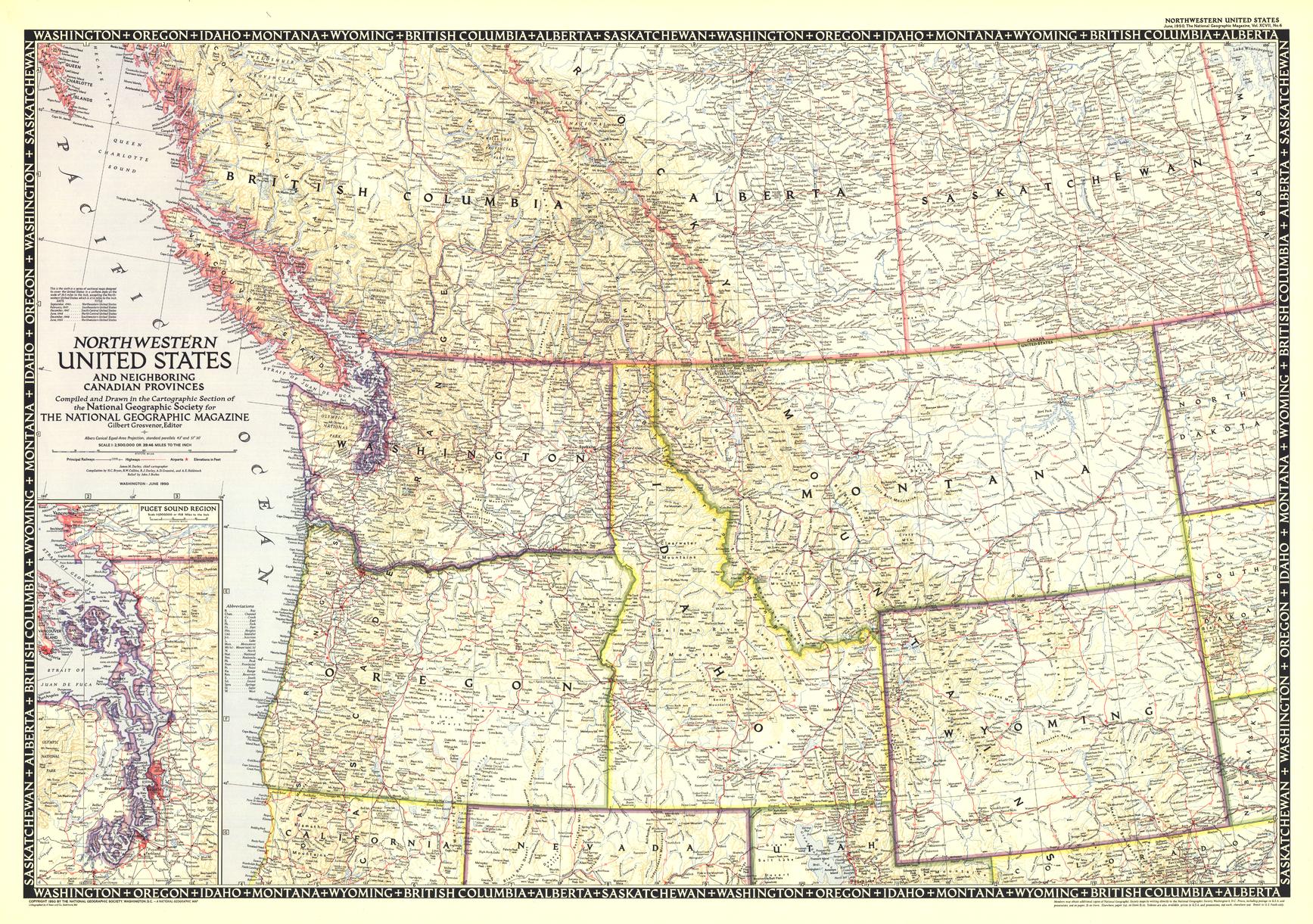
A sweeping post-war portrait of the Pacific Northwest and western Canada, Northwestern United States & Canadian Provinces captures a vast and interconnected region defined by mountains, forests, and frontier development. Published by National Geographic in June 1950, this map forms the sixth and final sheet in a celebrated series documenting the United States between 1945 and 1950.
Blending political clarity with geographic depth, it extends beyond national borders to show how landscapes and communities flow seamlessly across the U.S.–Canada divide.
Why This Map Stands Out
A cross-border perspective
Unites U.S. states and Canadian provinces in one cohesive regional view.
Part of a landmark series
The final map in National Geographic’s 1945–1950 sectional set.
Post-war cartographic style
Clean, confident design reflecting a period of growth and optimism.
Large-format impact
A bold wall map with strong visual presence.
A collector’s centrepiece
Ideal for those building a complete mid-century U.S. series.
🗺️ What the Map Shows
- The Northwestern United States, including:
- Washington
- Oregon
- Idaho
- Montana
- Wyoming
- Southern portions of key Canadian provinces:
- British Columbia
- Alberta
- Saskatchewan
- Major mountain systems, river networks, and regional landforms
- Cities, towns, and transport connections across borders
- A unified geographic framework linking landscape, settlement, and political boundaries
📐 Size & Format
918 mm (W) × 646 mm (H)
Landscape orientation (large format)
A commanding size ideal for:
- Feature walls and offices
- Libraries and map collections
- Educational and institutional settings
- Interiors seeking a bold, heritage-style display
✨ Premium Finishes
| Format | Description |
|---|---|
| 📜 Paper (160 gsm) | Heavyweight matte-coated paper—ideal for framing. Preserves fine detail and colour. |
| 🧼 Laminated (Encapsulated) | Sealed in 2 × 80-micron gloss laminate. Durable and protective for long-term use. |
| 🪵 Laminated + Timber Hang Rails | Laminated map mounted with lacquered natural timber rails and hanging cord—ready to display. |
| 🖼️ Canvas (395 gsm HP Professional Matte) | Printed with archival pigment inks. Enhances depth and presentation. |
| 🪵 Canvas + Timber Hang Rails | Canvas paired with timber rails for a refined, gallery-style finish. |
🔨 Please allow up to 10 working days for professionally mounted hang-railed finishes.
📊 Specifications
| Feature | Detail |
|---|---|
| Title | Northwestern United States & Canadian Provinces |
| Publisher | National Geographic |
| Published | 1950 |
| Scale | 1:2,500,000 |
| Dimensions | 918 mm × 646 mm |
| Orientation | Landscape |
| Map Type | Historical / Political |
| Coverage | Northwestern USA & Western Canada |
| Collections | North America, Canada, USA, Historical, Political |
| Materials | 160 gsm matte paper · 2 × 80-micron laminate · 395 gsm HP Professional Matte Canvas |
| Inks | Pigment-based, fade-resistant |
| Origin | Printed in Australia |
🎯 Ideal For
- Collectors of mid-century National Geographic maps
- Enthusiasts of Pacific Northwest and Western Canada geography
- Students of cross-border regional development
- Interiors seeking a large, statement heritage map
- Gift buyers looking for a timeless and substantial piece
⛰️ A Region Without Borders
This map reflects a landscape where:
- Mountain ranges and rivers ignore political boundaries
- Communities developed along shared geographic corridors
- Post-war growth reshaped both nations
- The Pacific Northwest emerged as a region of scale and opportunity
It’s a view of North America as a connected whole—where geography defines the region more than borders ever could.
🤝 Our Commitment
- Printed in Australia using archival-quality materials
- Faithfully reproduced to preserve original colour and detail
- Premium finishes designed for long-term display
- Each map is hand-checked and carefully packed
🚚 Delivery
- Rolled (Paper, Laminated, Canvas): Dispatch within 1–2 business days
- Hang-Railed Finishes: Made to order — allow up to 10 working days
Complete the series with a true standout—
a map that captures the Northwestern United States and Canada in one unified, timeless view.
Original: $50.05
-65%$50.05
$17.52Product Information
Product Information
Shipping & Returns
Shipping & Returns
Description
Historical Regional Wall Map | Cross-Border Landscapes & Political Detail | Large Format (918 × 646 mm) | Premium Finishes
A sweeping post-war portrait of the Pacific Northwest and western Canada, Northwestern United States & Canadian Provinces captures a vast and interconnected region defined by mountains, forests, and frontier development. Published by National Geographic in June 1950, this map forms the sixth and final sheet in a celebrated series documenting the United States between 1945 and 1950.
Blending political clarity with geographic depth, it extends beyond national borders to show how landscapes and communities flow seamlessly across the U.S.–Canada divide.
Why This Map Stands Out
A cross-border perspective
Unites U.S. states and Canadian provinces in one cohesive regional view.
Part of a landmark series
The final map in National Geographic’s 1945–1950 sectional set.
Post-war cartographic style
Clean, confident design reflecting a period of growth and optimism.
Large-format impact
A bold wall map with strong visual presence.
A collector’s centrepiece
Ideal for those building a complete mid-century U.S. series.
🗺️ What the Map Shows
- The Northwestern United States, including:
- Washington
- Oregon
- Idaho
- Montana
- Wyoming
- Southern portions of key Canadian provinces:
- British Columbia
- Alberta
- Saskatchewan
- Major mountain systems, river networks, and regional landforms
- Cities, towns, and transport connections across borders
- A unified geographic framework linking landscape, settlement, and political boundaries
📐 Size & Format
918 mm (W) × 646 mm (H)
Landscape orientation (large format)
A commanding size ideal for:
- Feature walls and offices
- Libraries and map collections
- Educational and institutional settings
- Interiors seeking a bold, heritage-style display
✨ Premium Finishes
| Format | Description |
|---|---|
| 📜 Paper (160 gsm) | Heavyweight matte-coated paper—ideal for framing. Preserves fine detail and colour. |
| 🧼 Laminated (Encapsulated) | Sealed in 2 × 80-micron gloss laminate. Durable and protective for long-term use. |
| 🪵 Laminated + Timber Hang Rails | Laminated map mounted with lacquered natural timber rails and hanging cord—ready to display. |
| 🖼️ Canvas (395 gsm HP Professional Matte) | Printed with archival pigment inks. Enhances depth and presentation. |
| 🪵 Canvas + Timber Hang Rails | Canvas paired with timber rails for a refined, gallery-style finish. |
🔨 Please allow up to 10 working days for professionally mounted hang-railed finishes.
📊 Specifications
| Feature | Detail |
|---|---|
| Title | Northwestern United States & Canadian Provinces |
| Publisher | National Geographic |
| Published | 1950 |
| Scale | 1:2,500,000 |
| Dimensions | 918 mm × 646 mm |
| Orientation | Landscape |
| Map Type | Historical / Political |
| Coverage | Northwestern USA & Western Canada |
| Collections | North America, Canada, USA, Historical, Political |
| Materials | 160 gsm matte paper · 2 × 80-micron laminate · 395 gsm HP Professional Matte Canvas |
| Inks | Pigment-based, fade-resistant |
| Origin | Printed in Australia |
🎯 Ideal For
- Collectors of mid-century National Geographic maps
- Enthusiasts of Pacific Northwest and Western Canada geography
- Students of cross-border regional development
- Interiors seeking a large, statement heritage map
- Gift buyers looking for a timeless and substantial piece
⛰️ A Region Without Borders
This map reflects a landscape where:
- Mountain ranges and rivers ignore political boundaries
- Communities developed along shared geographic corridors
- Post-war growth reshaped both nations
- The Pacific Northwest emerged as a region of scale and opportunity
It’s a view of North America as a connected whole—where geography defines the region more than borders ever could.
🤝 Our Commitment
- Printed in Australia using archival-quality materials
- Faithfully reproduced to preserve original colour and detail
- Premium finishes designed for long-term display
- Each map is hand-checked and carefully packed
🚚 Delivery
- Rolled (Paper, Laminated, Canvas): Dispatch within 1–2 business days
- Hang-Railed Finishes: Made to order — allow up to 10 working days
Complete the series with a true standout—
a map that captures the Northwestern United States and Canada in one unified, timeless view.


