O'ahu, Hawai'i Wall Map 1219 x 914mm
Regional Detail | Neighborhoods & POIs | ZIP Boundaries | Premium Finishes
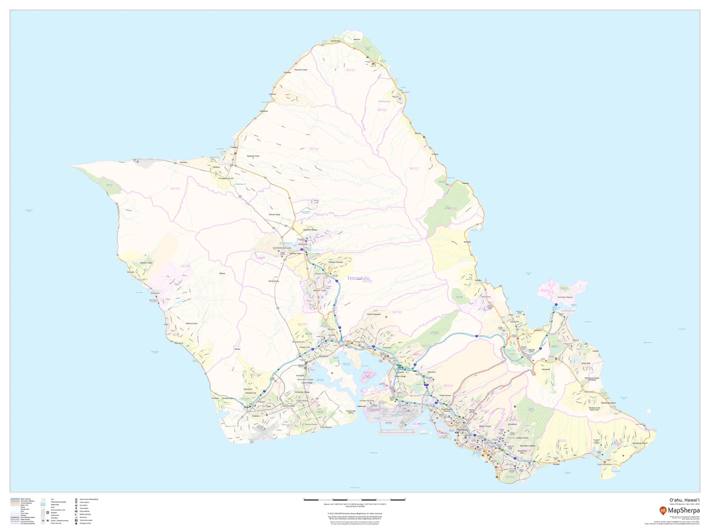
See Oʻahu at a glance—from the Koʻolau and Waiʻanae ranges to Pearl Harbor, Waikīkī, the North Shore, and the windward and leeward coasts. This large-format wall map pairs clean political and administrative detail with a crisp regional base, making it ideal for planning, teaching, travel, and display.
🗺️ Map Features
-
Island-Wide Reference – Major highways and roads labelled; neighborhood names and key towns clearly identified for easy navigation.
-
Transit & Hubs – Rail/rapid transit lines and stations (where shown), plus airports, harbors, and other transportation points of interest.
-
Land Use at a Glance – Parks and recreation areas, campuses, hospital precincts, industrial zones, and other high-level land use polygons.
-
Coastline & Waterways – Bays, inlets, and key water features legibly presented for coastal context and orientation.
-
ZIP Code Boundaries – Displayed as a secondary layer for service planning, logistics, and demographic reference.
-
Wall-Optimized Cartography – Balanced label hierarchy and uncluttered symbology for clarity at viewing distance.
All features appear as depicted on the printed map.
✨ Available Finishes
| Format | Description |
|---|---|
| 📜 Paper (160 gsm) | Heavyweight matte-coated paper—perfect for framing under glass. |
| 🧼 Laminated (Encapsulated) | Fully sealed in 80-micron gloss laminate—durable, wipe-clean, annotation-friendly. |
| 🪵 Laminated with Wooden Hang Rails | Laminated map mounted with lacquered natural timber rails (top & bottom) and a hanging cord—ready to display. |
| 🖼️ Canvas (395 gsm) | HP Professional Matte Canvas with archival pigment-based inks—rich texture, fade-resistant, gallery-grade. |
| 🪵 Canvas with Wooden Hang Rails | Canvas finished with lacquered timber rails and a hanging cord—timeless, frame-free presentation. |
🔨 Hang-railed maps are made to order—please allow up to 10 working days for professional mounting.
📐 Specifications
| Feature | Detail |
|---|---|
| Title | Oʻahu, Hawaiʻi Wall Map |
| Map Type | Regional Reference (Political / Land Use) |
| Scale | 1:65,000 (≈ 1 cm = 650 m) |
| Dimensions | 1219 mm (W) × 914 mm (H) |
| Orientation | Landscape |
| Published | 2020 |
| Materials | Paper, Laminated, Canvas, With or Without Timber Rails |
| Printing | Archival pigment-based inks, fade-resistant |
💡 Why You’ll Love It
-
Island clarity for homes, classrooms, coworking spaces, and offices.
-
Actionable detail—neighborhoods, transport, POIs, and ZIPs on one clean canvas.
-
Five premium finishes to match your space and usage.
-
Built to last—laminated/canvas options stand up to everyday handling.
🚚 Delivery
-
Paper, Laminated & Canvas (rolled): Usually ships within 1–2 business days.
-
Hang-railed versions: Made to order; allow up to 10 working days.
-
Packaging: Securely protected to arrive in pristine condition.
Bring Oʻahu’s neighborhoods, coasts, and connections into daily focus. Choose your finish, hang with ease, and enjoy a map that’s both beautiful and deeply useful.
Original: $64.36
-65%$64.36
$22.53Product Information
Product Information
Shipping & Returns
Shipping & Returns
Description
Regional Detail | Neighborhoods & POIs | ZIP Boundaries | Premium Finishes
See Oʻahu at a glance—from the Koʻolau and Waiʻanae ranges to Pearl Harbor, Waikīkī, the North Shore, and the windward and leeward coasts. This large-format wall map pairs clean political and administrative detail with a crisp regional base, making it ideal for planning, teaching, travel, and display.
🗺️ Map Features
-
Island-Wide Reference – Major highways and roads labelled; neighborhood names and key towns clearly identified for easy navigation.
-
Transit & Hubs – Rail/rapid transit lines and stations (where shown), plus airports, harbors, and other transportation points of interest.
-
Land Use at a Glance – Parks and recreation areas, campuses, hospital precincts, industrial zones, and other high-level land use polygons.
-
Coastline & Waterways – Bays, inlets, and key water features legibly presented for coastal context and orientation.
-
ZIP Code Boundaries – Displayed as a secondary layer for service planning, logistics, and demographic reference.
-
Wall-Optimized Cartography – Balanced label hierarchy and uncluttered symbology for clarity at viewing distance.
All features appear as depicted on the printed map.
✨ Available Finishes
| Format | Description |
|---|---|
| 📜 Paper (160 gsm) | Heavyweight matte-coated paper—perfect for framing under glass. |
| 🧼 Laminated (Encapsulated) | Fully sealed in 80-micron gloss laminate—durable, wipe-clean, annotation-friendly. |
| 🪵 Laminated with Wooden Hang Rails | Laminated map mounted with lacquered natural timber rails (top & bottom) and a hanging cord—ready to display. |
| 🖼️ Canvas (395 gsm) | HP Professional Matte Canvas with archival pigment-based inks—rich texture, fade-resistant, gallery-grade. |
| 🪵 Canvas with Wooden Hang Rails | Canvas finished with lacquered timber rails and a hanging cord—timeless, frame-free presentation. |
🔨 Hang-railed maps are made to order—please allow up to 10 working days for professional mounting.
📐 Specifications
| Feature | Detail |
|---|---|
| Title | Oʻahu, Hawaiʻi Wall Map |
| Map Type | Regional Reference (Political / Land Use) |
| Scale | 1:65,000 (≈ 1 cm = 650 m) |
| Dimensions | 1219 mm (W) × 914 mm (H) |
| Orientation | Landscape |
| Published | 2020 |
| Materials | Paper, Laminated, Canvas, With or Without Timber Rails |
| Printing | Archival pigment-based inks, fade-resistant |
💡 Why You’ll Love It
-
Island clarity for homes, classrooms, coworking spaces, and offices.
-
Actionable detail—neighborhoods, transport, POIs, and ZIPs on one clean canvas.
-
Five premium finishes to match your space and usage.
-
Built to last—laminated/canvas options stand up to everyday handling.
🚚 Delivery
-
Paper, Laminated & Canvas (rolled): Usually ships within 1–2 business days.
-
Hang-railed versions: Made to order; allow up to 10 working days.
-
Packaging: Securely protected to arrive in pristine condition.
Bring Oʻahu’s neighborhoods, coasts, and connections into daily focus. Choose your finish, hang with ease, and enjoy a map that’s both beautiful and deeply useful.


