Ocean Floor around Antarctica - Atlas of the World, 11th Edition by National Geographic
Atlas of the World (11th Edition) | Antarctic Seafloor & Bathymetry | Physical Wall Map | Multiple Sizes | Premium Finishes
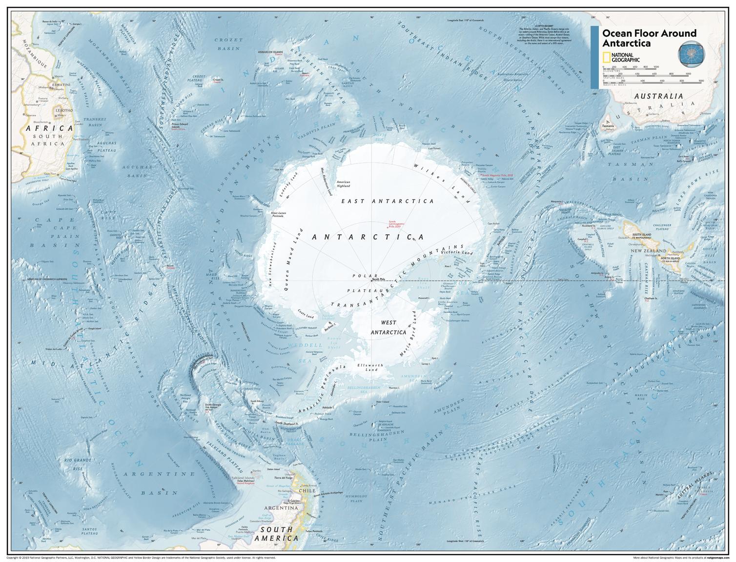
A rare and fascinating perspective on the hidden world beneath the Southern Ocean, Ocean Floor Around Antarctica reveals the dramatic contours of the seafloor encircling Antarctica. Published by National Geographic as part of the Atlas of the World, 11th Edition, this map uses advanced cartographic techniques to bring submarine landscapes into sharp, visual clarity.
From deep ocean trenches to vast underwater ridges, it offers a compelling view of a region few ever see—yet one that plays a critical role in Earth’s climate and ocean systems.
Why This Map Stands Out
A view beneath the surface
Maps the ocean floor surrounding Antarctica in exceptional detail.
Atlas-quality cartography
Derived from National Geographic’s authoritative 11th Edition.
Striking physical contrasts
Uses colour and shading to highlight underwater terrain.
Educational and unique
Perfect for teaching oceanography, geology, and environmental science.
A distinctive wall map
An uncommon subject that makes for a compelling display.
🌊 What the Map Shows
- The seafloor surrounding Antarctica and the Southern Ocean
- Major underwater features, including:
- Ocean basins and abyssal plains
- Mid-ocean ridges and submarine plateaus
- Trenches and continental shelves
- Bathymetric detail revealing depth and structure beneath the ocean
- A polar-centred perspective of the Southern Hemisphere
- A framework linking ocean depth, geology, and global systems
📐 Projection & Design
-
Projection: Azimuthal Equidistant (centred on the South Pole)
- Maintains accurate distances from the centre point
- Ideal for polar and hemispheric mapping
-
Style:
- High-contrast bathymetric shading
- Classic National Geographic colour palette
- Clean typography for clarity and accessibility
📐 Sizes & Format
Standard Size:
798 mm (W) × 610 mm (H)
Supermap Size:
1197 mm (W) × 915 mm (H)
Orientation: Landscape
Perfect for:
- Classrooms and STEM learning environments
- Universities and research spaces
- Offices and environmental planning settings
- Feature walls showcasing unique geographic themes
✨ Premium Finishes
| Format | Description |
|---|---|
| 📜 Paper (160 gsm) | Heavyweight matte-coated paper—ideal for framing. Preserves fine bathymetric detail. |
| 🧼 Laminated (True Encapsulation) | 2 × 80-micron gloss laminate. Durable, wipe-clean, and suitable for teaching use. |
| 🪵 Laminated + Timber Hang Rails | Ready-to-hang with lacquered natural timber rails. Allow up to 10 working days. |
| 🖼️ Archival Canvas (395 gsm HP Professional Matte) | Museum-grade finish with pigment-based, fade-resistant inks. |
| 🪵 Canvas + Timber Hang Rails | Gallery-ready presentation. Allow up to 10 working days. |
📊 Specifications
| Feature | Detail |
|---|---|
| Title | Ocean Floor Around Antarctica |
| Publisher | National Geographic |
| Published | 2019 |
| Atlas | Atlas of the World, 11th Edition (Plate 119) |
| Scale | 1:17,417,000 |
| Sizes | 790 × 610 mm · 1197 × 915 mm |
| Orientation | Landscape |
| Projection | Azimuthal Equidistant |
| Map Type | Physical / Bathymetric |
| Coverage | Southern Ocean & Antarctic Seafloor |
| Collections | Oceans, Physical |
| Materials | 160 gsm matte paper · 2 × 80-micron laminate · 395 gsm HP Professional Matte Canvas |
| Inks | Pigment-based, fade-resistant |
| Origin | Printed in Australia |
🎯 Ideal For
- Students and educators of geography, oceanography, and earth science
- Researchers and professionals in climate and marine studies
- Collectors of National Geographic physical maps
- Interiors seeking a unique, conversation-starting display piece
- Gift buyers looking for a distinctive and educational map
🌐 The Hidden Landscape of the Southern Ocean
Beneath the waves lies a world as dynamic as any continent:
- Mountain ranges and valleys carved into the seafloor
- Vast basins shaping global ocean circulation
- Geological structures influencing climate systems
- A hidden terrain critical to understanding our planet
This map reveals that unseen world—offering a clear and compelling view of the Earth beneath the ocean’s surface.
🤝 Our Commitment
- Printed in Australia using archival-quality materials
- Faithfully reproduced to preserve clarity and depth
- Premium finishes designed for long-term display
- Each map is hand-checked and carefully packed
🚚 Delivery
- Rolled (Paper, Laminated, Canvas): Dispatch within 1–2 business days
- Hang-Railed Finishes: Made to order — allow up to 10 working days
Explore what lies beneath—
a map that brings the Antarctic seafloor into sharp, scientific focus.
Original: $50.05
-65%$50.05
$17.52Product Information
Product Information
Shipping & Returns
Shipping & Returns
Description
Atlas of the World (11th Edition) | Antarctic Seafloor & Bathymetry | Physical Wall Map | Multiple Sizes | Premium Finishes
A rare and fascinating perspective on the hidden world beneath the Southern Ocean, Ocean Floor Around Antarctica reveals the dramatic contours of the seafloor encircling Antarctica. Published by National Geographic as part of the Atlas of the World, 11th Edition, this map uses advanced cartographic techniques to bring submarine landscapes into sharp, visual clarity.
From deep ocean trenches to vast underwater ridges, it offers a compelling view of a region few ever see—yet one that plays a critical role in Earth’s climate and ocean systems.
Why This Map Stands Out
A view beneath the surface
Maps the ocean floor surrounding Antarctica in exceptional detail.
Atlas-quality cartography
Derived from National Geographic’s authoritative 11th Edition.
Striking physical contrasts
Uses colour and shading to highlight underwater terrain.
Educational and unique
Perfect for teaching oceanography, geology, and environmental science.
A distinctive wall map
An uncommon subject that makes for a compelling display.
🌊 What the Map Shows
- The seafloor surrounding Antarctica and the Southern Ocean
- Major underwater features, including:
- Ocean basins and abyssal plains
- Mid-ocean ridges and submarine plateaus
- Trenches and continental shelves
- Bathymetric detail revealing depth and structure beneath the ocean
- A polar-centred perspective of the Southern Hemisphere
- A framework linking ocean depth, geology, and global systems
📐 Projection & Design
-
Projection: Azimuthal Equidistant (centred on the South Pole)
- Maintains accurate distances from the centre point
- Ideal for polar and hemispheric mapping
-
Style:
- High-contrast bathymetric shading
- Classic National Geographic colour palette
- Clean typography for clarity and accessibility
📐 Sizes & Format
Standard Size:
798 mm (W) × 610 mm (H)
Supermap Size:
1197 mm (W) × 915 mm (H)
Orientation: Landscape
Perfect for:
- Classrooms and STEM learning environments
- Universities and research spaces
- Offices and environmental planning settings
- Feature walls showcasing unique geographic themes
✨ Premium Finishes
| Format | Description |
|---|---|
| 📜 Paper (160 gsm) | Heavyweight matte-coated paper—ideal for framing. Preserves fine bathymetric detail. |
| 🧼 Laminated (True Encapsulation) | 2 × 80-micron gloss laminate. Durable, wipe-clean, and suitable for teaching use. |
| 🪵 Laminated + Timber Hang Rails | Ready-to-hang with lacquered natural timber rails. Allow up to 10 working days. |
| 🖼️ Archival Canvas (395 gsm HP Professional Matte) | Museum-grade finish with pigment-based, fade-resistant inks. |
| 🪵 Canvas + Timber Hang Rails | Gallery-ready presentation. Allow up to 10 working days. |
📊 Specifications
| Feature | Detail |
|---|---|
| Title | Ocean Floor Around Antarctica |
| Publisher | National Geographic |
| Published | 2019 |
| Atlas | Atlas of the World, 11th Edition (Plate 119) |
| Scale | 1:17,417,000 |
| Sizes | 790 × 610 mm · 1197 × 915 mm |
| Orientation | Landscape |
| Projection | Azimuthal Equidistant |
| Map Type | Physical / Bathymetric |
| Coverage | Southern Ocean & Antarctic Seafloor |
| Collections | Oceans, Physical |
| Materials | 160 gsm matte paper · 2 × 80-micron laminate · 395 gsm HP Professional Matte Canvas |
| Inks | Pigment-based, fade-resistant |
| Origin | Printed in Australia |
🎯 Ideal For
- Students and educators of geography, oceanography, and earth science
- Researchers and professionals in climate and marine studies
- Collectors of National Geographic physical maps
- Interiors seeking a unique, conversation-starting display piece
- Gift buyers looking for a distinctive and educational map
🌐 The Hidden Landscape of the Southern Ocean
Beneath the waves lies a world as dynamic as any continent:
- Mountain ranges and valleys carved into the seafloor
- Vast basins shaping global ocean circulation
- Geological structures influencing climate systems
- A hidden terrain critical to understanding our planet
This map reveals that unseen world—offering a clear and compelling view of the Earth beneath the ocean’s surface.
🤝 Our Commitment
- Printed in Australia using archival-quality materials
- Faithfully reproduced to preserve clarity and depth
- Premium finishes designed for long-term display
- Each map is hand-checked and carefully packed
🚚 Delivery
- Rolled (Paper, Laminated, Canvas): Dispatch within 1–2 business days
- Hang-Railed Finishes: Made to order — allow up to 10 working days
Explore what lies beneath—
a map that brings the Antarctic seafloor into sharp, scientific focus.