Oceans: Planet Ocean - Atlas of the World, 10th Edition by National Geographic
Atlas of the World (10th Edition) | Global Ocean Systems, Climate & Human Impact | Thematic Wall Map | 711 × 559 mm | Premium Finishes
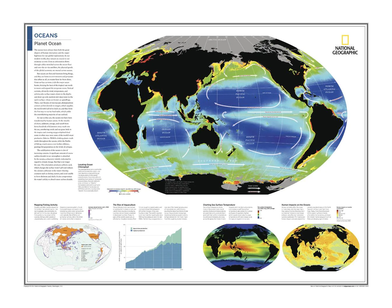
A masterful synthesis of science and cartography, Oceans: Planet Ocean reveals the oceans not as empty blue space—but as a dynamic, living system that underpins life on Earth. Published by National Geographic as part of the Atlas of the World, 10th Edition, this map layers global datasets to show how biology, climate, and human activity interact across the world’s seas.
From microscopic plankton blooms to global fisheries and warming waters, it offers a big-picture understanding of the oceans as a system in motion.
Why This Map Stands Out
A complete ocean systems view
Integrates biology, climate, and economics into a single, coherent map.
Data-rich, yet highly readable
Complex global datasets presented with clarity and balance.
Contemporary and relevant
Addresses modern pressures including overfishing, aquaculture, and climate change.
Atlas-grade authority
Drawn from National Geographic’s flagship 10th Edition.
A compelling visual narrative
Designed not just to inform—but to spark curiosity and discussion.
🌊 What the Map Shows
🌱 Ocean Productivity (Chlorophyll)
- Global distribution of chlorophyll concentrations, revealing phytoplankton activity
- Highlights biologically rich zones such as coastal upwellings and polar waters
- Demonstrates how microscopic life supports the entire marine food web
🎣 Global Fishing Activity
- Mapping of major commercial fishing regions
- Shows intensity and geographic spread of global fisheries
- Connects ocean productivity with human harvesting patterns
🐟 The Rise of Aquaculture
- Growth and distribution of fish farming and aquaculture industries
- Illustrates shifting reliance from wild capture to managed production
- Highlights Asia as a dominant region in aquaculture expansion
🌡️ Sea Surface Temperature
- Global patterns of ocean temperature
- Links to major climate systems such as currents and atmospheric circulation
- Shows temperature gradients from equatorial to polar regions
⚠️ Human Impacts on the Oceans
- Overfishing, habitat pressure, and environmental stress
- Pollution and ecosystem degradation
- A growing footprint of human activity across marine environments
🌐 A System That Sustains the Planet
The oceans are Earth’s life-support system:
- Regulating climate through heat storage and circulation
- Producing oxygen via phytoplankton
- Feeding billions through fisheries and aquaculture
- Driving weather systems across continents
- Absorbing carbon and moderating global change
This map makes those invisible processes visible—showing how the oceans function as a connected, global engine of life.
📐 Size & Format
711 mm (W) × 559 mm (H)
Landscape orientation
A highly versatile size suited for:
- Classrooms and STEM learning environments
- University and research settings
- Offices and policy spaces
- Home interiors with a global or scientific focus
✨ Premium Finishes
| Format | Description |
|---|---|
| 📜 Heavyweight Paper (160 gsm matte) | Archival-quality, low-glare finish—ideal for framing and detailed study. |
| 🧼 Laminated (True Encapsulation) | 2 × 80-micron gloss laminate, edge-sealed. Durable, wipe-clean, and perfect for annotation or teaching. |
| 🪵 Laminated + Timber Hang Rails | Ready-to-hang with lacquered natural timber rails and cord. Allow up to 10 working days. |
| 🖼️ Archival Canvas (395 gsm HP Professional Matte) | Museum-grade finish with pigment-based, fade-resistant inks for depth and longevity. |
| 🪵 Canvas + Timber Hang Rails | Gallery-ready presentation. Allow up to 10 working days. |
📊 Specifications
| Feature | Detail |
|---|---|
| Title | Oceans: Planet Ocean |
| Publisher | National Geographic |
| Published | 2015 |
| Atlas | Atlas of the World, 10th Edition (Plate 7) |
| Dimensions | 711 mm × 559 mm |
| Orientation | Landscape |
| Map Type | Thematic |
| Coverage | Global Oceans |
| Collections | World, Oceans, Thematic |
| Materials | 160 gsm matte paper · 2 × 80-micron laminate · 395 gsm HP Professional Matte Canvas |
| Inks | Pigment-based, fade-resistant |
| Origin | Printed in Australia |
🎯 Ideal For
- Students and educators of marine science, geography, and climate systems
- Researchers and professionals in environmental and ocean studies
- Policy and planning environments focused on sustainability
- Collectors of National Geographic thematic maps
- Interiors seeking a modern, intelligent conversation piece
🌍 Why This Map Matters
In today’s world:
- Ocean temperatures are rising
- Fisheries are under pressure
- Aquaculture is expanding rapidly
- Marine ecosystems are changing in real time
This map doesn’t just show the oceans—it explains them. It provides a framework for understanding how natural systems and human activity are now deeply intertwined.
🤝 Our Commitment
- Printed in Australia using archival-quality materials
- Faithfully reproduced for maximum clarity and precision
- Premium finishes designed for long-term display
- Each map is hand-checked and carefully packed
🚚 Delivery
- Rolled (Paper, Laminated, Canvas): Dispatch within 1–2 business days
- Hang-Railed Finishes: Made to order — allow up to 10 working days
See the oceans as a system—not just a surface—
a map that reveals the forces shaping our blue planet, now and into the future.
Original: $50.05
-65%$50.05
$17.52Product Information
Product Information
Shipping & Returns
Shipping & Returns
Description
Atlas of the World (10th Edition) | Global Ocean Systems, Climate & Human Impact | Thematic Wall Map | 711 × 559 mm | Premium Finishes
A masterful synthesis of science and cartography, Oceans: Planet Ocean reveals the oceans not as empty blue space—but as a dynamic, living system that underpins life on Earth. Published by National Geographic as part of the Atlas of the World, 10th Edition, this map layers global datasets to show how biology, climate, and human activity interact across the world’s seas.
From microscopic plankton blooms to global fisheries and warming waters, it offers a big-picture understanding of the oceans as a system in motion.
Why This Map Stands Out
A complete ocean systems view
Integrates biology, climate, and economics into a single, coherent map.
Data-rich, yet highly readable
Complex global datasets presented with clarity and balance.
Contemporary and relevant
Addresses modern pressures including overfishing, aquaculture, and climate change.
Atlas-grade authority
Drawn from National Geographic’s flagship 10th Edition.
A compelling visual narrative
Designed not just to inform—but to spark curiosity and discussion.
🌊 What the Map Shows
🌱 Ocean Productivity (Chlorophyll)
- Global distribution of chlorophyll concentrations, revealing phytoplankton activity
- Highlights biologically rich zones such as coastal upwellings and polar waters
- Demonstrates how microscopic life supports the entire marine food web
🎣 Global Fishing Activity
- Mapping of major commercial fishing regions
- Shows intensity and geographic spread of global fisheries
- Connects ocean productivity with human harvesting patterns
🐟 The Rise of Aquaculture
- Growth and distribution of fish farming and aquaculture industries
- Illustrates shifting reliance from wild capture to managed production
- Highlights Asia as a dominant region in aquaculture expansion
🌡️ Sea Surface Temperature
- Global patterns of ocean temperature
- Links to major climate systems such as currents and atmospheric circulation
- Shows temperature gradients from equatorial to polar regions
⚠️ Human Impacts on the Oceans
- Overfishing, habitat pressure, and environmental stress
- Pollution and ecosystem degradation
- A growing footprint of human activity across marine environments
🌐 A System That Sustains the Planet
The oceans are Earth’s life-support system:
- Regulating climate through heat storage and circulation
- Producing oxygen via phytoplankton
- Feeding billions through fisheries and aquaculture
- Driving weather systems across continents
- Absorbing carbon and moderating global change
This map makes those invisible processes visible—showing how the oceans function as a connected, global engine of life.
📐 Size & Format
711 mm (W) × 559 mm (H)
Landscape orientation
A highly versatile size suited for:
- Classrooms and STEM learning environments
- University and research settings
- Offices and policy spaces
- Home interiors with a global or scientific focus
✨ Premium Finishes
| Format | Description |
|---|---|
| 📜 Heavyweight Paper (160 gsm matte) | Archival-quality, low-glare finish—ideal for framing and detailed study. |
| 🧼 Laminated (True Encapsulation) | 2 × 80-micron gloss laminate, edge-sealed. Durable, wipe-clean, and perfect for annotation or teaching. |
| 🪵 Laminated + Timber Hang Rails | Ready-to-hang with lacquered natural timber rails and cord. Allow up to 10 working days. |
| 🖼️ Archival Canvas (395 gsm HP Professional Matte) | Museum-grade finish with pigment-based, fade-resistant inks for depth and longevity. |
| 🪵 Canvas + Timber Hang Rails | Gallery-ready presentation. Allow up to 10 working days. |
📊 Specifications
| Feature | Detail |
|---|---|
| Title | Oceans: Planet Ocean |
| Publisher | National Geographic |
| Published | 2015 |
| Atlas | Atlas of the World, 10th Edition (Plate 7) |
| Dimensions | 711 mm × 559 mm |
| Orientation | Landscape |
| Map Type | Thematic |
| Coverage | Global Oceans |
| Collections | World, Oceans, Thematic |
| Materials | 160 gsm matte paper · 2 × 80-micron laminate · 395 gsm HP Professional Matte Canvas |
| Inks | Pigment-based, fade-resistant |
| Origin | Printed in Australia |
🎯 Ideal For
- Students and educators of marine science, geography, and climate systems
- Researchers and professionals in environmental and ocean studies
- Policy and planning environments focused on sustainability
- Collectors of National Geographic thematic maps
- Interiors seeking a modern, intelligent conversation piece
🌍 Why This Map Matters
In today’s world:
- Ocean temperatures are rising
- Fisheries are under pressure
- Aquaculture is expanding rapidly
- Marine ecosystems are changing in real time
This map doesn’t just show the oceans—it explains them. It provides a framework for understanding how natural systems and human activity are now deeply intertwined.
🤝 Our Commitment
- Printed in Australia using archival-quality materials
- Faithfully reproduced for maximum clarity and precision
- Premium finishes designed for long-term display
- Each map is hand-checked and carefully packed
🚚 Delivery
- Rolled (Paper, Laminated, Canvas): Dispatch within 1–2 business days
- Hang-Railed Finishes: Made to order — allow up to 10 working days
See the oceans as a system—not just a surface—
a map that reveals the forces shaping our blue planet, now and into the future.


