Ohio Valley - Published 1985 by National Geographic
Making of America Series | Frontier History & Early Settlement | Historical Regional Wall Map | 690 × 518 mm | Premium Finishes
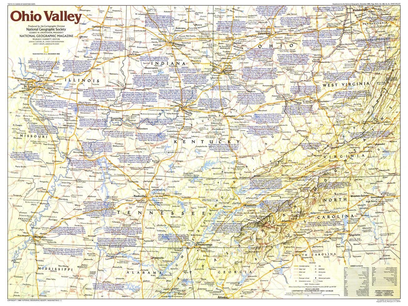
A landscape where America’s frontier story took shape, Ohio Valley captures the rivers, settlements, and routes that defined early westward expansion. Published by National Geographic in December 1985 as part of the Making of America series, this map blends geography with narrative, bringing to life the people and places that shaped the young nation.
Issued alongside the feature article “Daniel Boone, First Hero of the Frontier,” it offers a richly detailed view of a region central to America’s early identity.
Why This Map Stands Out
A frontier story mapped
Highlights the Ohio Valley as a gateway to westward expansion.
Part of the Making of America series
Combines cartographic precision with historical storytelling.
Rich in historical detail
Includes notes and points of interest tied to early settlement.
Iconic figures and places
Connects the landscape to legendary frontier personalities.
A refined wall map
Ideal for both education and display.
🗺️ What the Map Shows
- The Ohio Valley region of the United States
- Early frontier settlements, including:
- Harrodsburg — one of Kentucky’s earliest settlements
- Key historical locations such as:
- Birthplace of Davy Crockett in Tennessee
- Rivers, valleys, and terrain that guided settlement and travel
- Towns, transport routes, and regional connections
- Historical notes linking geography to exploration, migration, and settlement
📐 Size & Format
690 mm (W) × 518 mm (H)
Landscape orientation
A balanced format ideal for:
- Classrooms and history education
- Home offices and studies
- Libraries and heritage displays
- Pairing with other Making of America maps
✨ Premium Finishes
| Format | Description |
|---|---|
| 📜 Paper (160 gsm) | Heavyweight matte-coated paper—ideal for framing. Preserves fine detail and text clarity. |
| 🧼 Laminated (True Encapsulation) | 2 × 80-micron gloss laminate. Durable, wipe-clean, and perfect for reference use. |
| 🪵 Laminated + Timber Hang Rails | Ready-to-hang with lacquered natural timber rails. Allow up to 10 working days. |
| 🖼️ Archival Canvas (395 gsm HP Professional Matte) | Museum-grade finish with pigment-based, fade-resistant inks. |
| 🪵 Canvas + Timber Hang Rails | Gallery-ready presentation. Allow up to 10 working days. |
📊 Specifications
| Feature | Detail |
|---|---|
| Title | Ohio Valley |
| Publisher | National Geographic |
| Published | 1985 |
| Series | Making of America |
| Scale | 1:1,551,000 |
| Dimensions | 690 mm × 518 mm |
| Orientation | Landscape |
| Map Type | Historical / Regional |
| Coverage | Ohio Valley, USA |
| Collections | USA, Historical, Regional |
| Materials | 160 gsm matte paper · 2 × 80-micron laminate · 395 gsm HP Professional Matte Canvas |
| Inks | Pigment-based, fade-resistant |
| Origin | Printed in Australia |
🎯 Ideal For
- Students and educators of American frontier history
- Collectors of National Geographic historical maps
- Enthusiasts of early settlement and westward expansion
- Interiors seeking a heritage-inspired display piece
- Gift buyers looking for a meaningful historical map
🌄 Where the Frontier Began
The Ohio Valley was a turning point in American history:
- A corridor for exploration and migration westward
- A landscape of rivers guiding settlement and trade
- Home to early frontier communities
- A stage for figures who became national legends
This map captures that moment—offering a clear and compelling view of a region where America’s frontier story truly began.
🤝 Our Commitment
- Printed in Australia using archival-quality materials
- Faithfully reproduced to preserve clarity and historical detail
- Premium finishes designed for long-term display
- Each map is hand-checked and carefully packed
🚚 Delivery
- Rolled (Paper, Laminated, Canvas): Dispatch within 1–2 business days
- Hang-Railed Finishes: Made to order — allow up to 10 working days
Step into the early frontier—
a map that brings the Ohio Valley and America’s beginnings into sharp focus.
Original: $50.05
-65%$50.05
$17.52Product Information
Product Information
Shipping & Returns
Shipping & Returns
Description
Making of America Series | Frontier History & Early Settlement | Historical Regional Wall Map | 690 × 518 mm | Premium Finishes
A landscape where America’s frontier story took shape, Ohio Valley captures the rivers, settlements, and routes that defined early westward expansion. Published by National Geographic in December 1985 as part of the Making of America series, this map blends geography with narrative, bringing to life the people and places that shaped the young nation.
Issued alongside the feature article “Daniel Boone, First Hero of the Frontier,” it offers a richly detailed view of a region central to America’s early identity.
Why This Map Stands Out
A frontier story mapped
Highlights the Ohio Valley as a gateway to westward expansion.
Part of the Making of America series
Combines cartographic precision with historical storytelling.
Rich in historical detail
Includes notes and points of interest tied to early settlement.
Iconic figures and places
Connects the landscape to legendary frontier personalities.
A refined wall map
Ideal for both education and display.
🗺️ What the Map Shows
- The Ohio Valley region of the United States
- Early frontier settlements, including:
- Harrodsburg — one of Kentucky’s earliest settlements
- Key historical locations such as:
- Birthplace of Davy Crockett in Tennessee
- Rivers, valleys, and terrain that guided settlement and travel
- Towns, transport routes, and regional connections
- Historical notes linking geography to exploration, migration, and settlement
📐 Size & Format
690 mm (W) × 518 mm (H)
Landscape orientation
A balanced format ideal for:
- Classrooms and history education
- Home offices and studies
- Libraries and heritage displays
- Pairing with other Making of America maps
✨ Premium Finishes
| Format | Description |
|---|---|
| 📜 Paper (160 gsm) | Heavyweight matte-coated paper—ideal for framing. Preserves fine detail and text clarity. |
| 🧼 Laminated (True Encapsulation) | 2 × 80-micron gloss laminate. Durable, wipe-clean, and perfect for reference use. |
| 🪵 Laminated + Timber Hang Rails | Ready-to-hang with lacquered natural timber rails. Allow up to 10 working days. |
| 🖼️ Archival Canvas (395 gsm HP Professional Matte) | Museum-grade finish with pigment-based, fade-resistant inks. |
| 🪵 Canvas + Timber Hang Rails | Gallery-ready presentation. Allow up to 10 working days. |
📊 Specifications
| Feature | Detail |
|---|---|
| Title | Ohio Valley |
| Publisher | National Geographic |
| Published | 1985 |
| Series | Making of America |
| Scale | 1:1,551,000 |
| Dimensions | 690 mm × 518 mm |
| Orientation | Landscape |
| Map Type | Historical / Regional |
| Coverage | Ohio Valley, USA |
| Collections | USA, Historical, Regional |
| Materials | 160 gsm matte paper · 2 × 80-micron laminate · 395 gsm HP Professional Matte Canvas |
| Inks | Pigment-based, fade-resistant |
| Origin | Printed in Australia |
🎯 Ideal For
- Students and educators of American frontier history
- Collectors of National Geographic historical maps
- Enthusiasts of early settlement and westward expansion
- Interiors seeking a heritage-inspired display piece
- Gift buyers looking for a meaningful historical map
🌄 Where the Frontier Began
The Ohio Valley was a turning point in American history:
- A corridor for exploration and migration westward
- A landscape of rivers guiding settlement and trade
- Home to early frontier communities
- A stage for figures who became national legends
This map captures that moment—offering a clear and compelling view of a region where America’s frontier story truly began.
🤝 Our Commitment
- Printed in Australia using archival-quality materials
- Faithfully reproduced to preserve clarity and historical detail
- Premium finishes designed for long-term display
- Each map is hand-checked and carefully packed
🚚 Delivery
- Rolled (Paper, Laminated, Canvas): Dispatch within 1–2 business days
- Hang-Railed Finishes: Made to order — allow up to 10 working days
Step into the early frontier—
a map that brings the Ohio Valley and America’s beginnings into sharp focus.


