ONC CHARTS AUSTRALIA Q-12
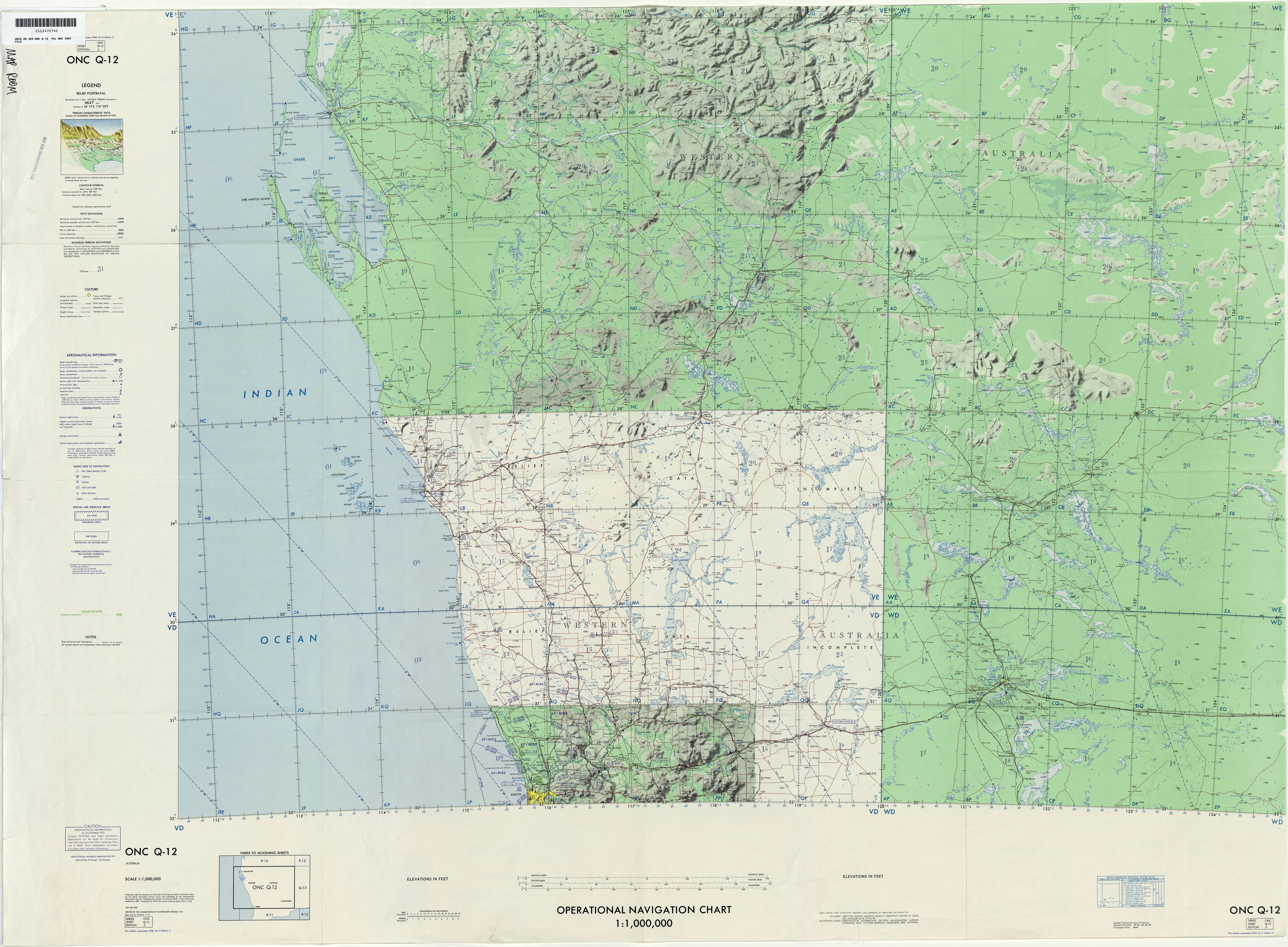
ONC Chart – Australia Q-12
Size: 1000 mm x 735 mm
The ONC (Operational Navigation Chart) Australia Q-12 delivers a large-format representation of Australia’s Q-12 sector, produced to the internationally recognised 1:1,000,000 scale. Designed with both topographic precision and aeronautical references, this chart offers a unique blend of natural landscape detail and infrastructure mapping.
Originally developed for aviation use, the Q-12 chart highlights physical features such as rivers, mountains, and coastlines, alongside cultural and man-made infrastructure including towns, villages, pipelines, roads, and railways. This dual-layered presentation makes it not only a useful teaching and planning tool but also a striking visual resource for collectors and enthusiasts.
⚠ Important Notice: Supplied strictly NOT FOR NAVIGATIONAL USE. Intended for educational, decorative, and planning purposes only.
✈ Key Features
-
Topographic Representation – Clear depiction of rivers, ranges, deserts, and coastal forms.
-
Aeronautical Heritage – Incorporates aviation reference data, reflecting its ONC origins.
-
Infrastructure Mapping – Identifies towns, villages, pipelines, railways, and major roads.
-
Readable Scale – At 1:1,000,000, provides both detail and wide geographic coverage.
-
Multi-Purpose Use – Suitable for education, aviation history, libraries, offices, or collectors.
📐 Technical Specifications
| Feature | Detail |
|---|---|
| Title | ONC Chart – Australia Q-12 |
| Coverage | Australia – Q-12 sector |
| Scale | 1:1,000,000 |
| Content | Topography, aeronautical references, towns, villages, pipelines, railways, roads |
| Use | Educational, decorative, training, planning |
| Warning | Not for navigational use |
| Production | Printed in Australia |
🖼 Available Formats
This chart is available in five premium formats, ensuring the right edition for every use:
📜 Paper Edition (160 gsm Premium Paper)
-
Printed on heavyweight 160 gsm paper.
-
Perfect for framing under glass in a traditional setting.
-
Accessible, elegant, and ideal for collectors or teaching displays.
✨ Laminated Edition (80 Micron Gloss Encapsulation)
-
Fully encapsulated in 80-micron gloss laminate.
-
Durable, wipe-clean, and resistant to handling wear.
-
Practical for classrooms, offices, and planning environments—use with map dots or markers.
🖌 Canvas Edition (395 gsm Matte Canvas)
-
Printed on archival-grade 395 gsm HP Professional Matte Canvas using pigment-based inks.
-
Fade-resistant, richly textured, and gallery-quality.
-
A prestige edition built to last for decades as both décor and reference.
🪵 Laminated with Hang Rails (Natural Timber)
-
Combines the resilience of lamination with professional presentation.
-
Mounted with lacquered natural timber rails (top and bottom).
-
Fitted with a sturdy hanging cord for easy wall display.
🪵 Canvas with Hang Rails (Natural Timber)
-
The premium collector’s edition: archival canvas with handcrafted timber hang rails.
-
Professionally mounted and lacquered for a refined finish.
-
Ideal for executive offices, libraries, or as a centrepiece for aviation and cartography enthusiasts.
Note: Please allow up to 10 working days for delivery of hang-railed editions, as they are custom-mounted by our professional framer.
🌏 Why Choose the ONC Chart – Australia Q-12?
The ONC Q-12 chart represents more than geographical data—it is a testament to aviation cartography and an invaluable resource for:
-
Educators & Trainers – Bringing geography, infrastructure, and aviation mapping to life.
-
Aviation Enthusiasts – Preserving the heritage of operational navigation charting.
-
Collectors & Historians – A technical artefact with enduring historical and display value.
-
Libraries & Offices – Adding technical refinement and visual presence to interiors.
-
Planners & Analysts – Offering a broad overview of landforms and infrastructure.
The ONC Q-12 unites scientific precision with aesthetic presentation, making it equally suitable as a working reference tool and a prestigious wall display.
Original: $50.05
-65%$50.05
$17.52Product Information
Product Information
Shipping & Returns
Shipping & Returns
Description
ONC Chart – Australia Q-12
Size: 1000 mm x 735 mm
The ONC (Operational Navigation Chart) Australia Q-12 delivers a large-format representation of Australia’s Q-12 sector, produced to the internationally recognised 1:1,000,000 scale. Designed with both topographic precision and aeronautical references, this chart offers a unique blend of natural landscape detail and infrastructure mapping.
Originally developed for aviation use, the Q-12 chart highlights physical features such as rivers, mountains, and coastlines, alongside cultural and man-made infrastructure including towns, villages, pipelines, roads, and railways. This dual-layered presentation makes it not only a useful teaching and planning tool but also a striking visual resource for collectors and enthusiasts.
⚠ Important Notice: Supplied strictly NOT FOR NAVIGATIONAL USE. Intended for educational, decorative, and planning purposes only.
✈ Key Features
-
Topographic Representation – Clear depiction of rivers, ranges, deserts, and coastal forms.
-
Aeronautical Heritage – Incorporates aviation reference data, reflecting its ONC origins.
-
Infrastructure Mapping – Identifies towns, villages, pipelines, railways, and major roads.
-
Readable Scale – At 1:1,000,000, provides both detail and wide geographic coverage.
-
Multi-Purpose Use – Suitable for education, aviation history, libraries, offices, or collectors.
📐 Technical Specifications
| Feature | Detail |
|---|---|
| Title | ONC Chart – Australia Q-12 |
| Coverage | Australia – Q-12 sector |
| Scale | 1:1,000,000 |
| Content | Topography, aeronautical references, towns, villages, pipelines, railways, roads |
| Use | Educational, decorative, training, planning |
| Warning | Not for navigational use |
| Production | Printed in Australia |
🖼 Available Formats
This chart is available in five premium formats, ensuring the right edition for every use:
📜 Paper Edition (160 gsm Premium Paper)
-
Printed on heavyweight 160 gsm paper.
-
Perfect for framing under glass in a traditional setting.
-
Accessible, elegant, and ideal for collectors or teaching displays.
✨ Laminated Edition (80 Micron Gloss Encapsulation)
-
Fully encapsulated in 80-micron gloss laminate.
-
Durable, wipe-clean, and resistant to handling wear.
-
Practical for classrooms, offices, and planning environments—use with map dots or markers.
🖌 Canvas Edition (395 gsm Matte Canvas)
-
Printed on archival-grade 395 gsm HP Professional Matte Canvas using pigment-based inks.
-
Fade-resistant, richly textured, and gallery-quality.
-
A prestige edition built to last for decades as both décor and reference.
🪵 Laminated with Hang Rails (Natural Timber)
-
Combines the resilience of lamination with professional presentation.
-
Mounted with lacquered natural timber rails (top and bottom).
-
Fitted with a sturdy hanging cord for easy wall display.
🪵 Canvas with Hang Rails (Natural Timber)
-
The premium collector’s edition: archival canvas with handcrafted timber hang rails.
-
Professionally mounted and lacquered for a refined finish.
-
Ideal for executive offices, libraries, or as a centrepiece for aviation and cartography enthusiasts.
Note: Please allow up to 10 working days for delivery of hang-railed editions, as they are custom-mounted by our professional framer.
🌏 Why Choose the ONC Chart – Australia Q-12?
The ONC Q-12 chart represents more than geographical data—it is a testament to aviation cartography and an invaluable resource for:
-
Educators & Trainers – Bringing geography, infrastructure, and aviation mapping to life.
-
Aviation Enthusiasts – Preserving the heritage of operational navigation charting.
-
Collectors & Historians – A technical artefact with enduring historical and display value.
-
Libraries & Offices – Adding technical refinement and visual presence to interiors.
-
Planners & Analysts – Offering a broad overview of landforms and infrastructure.
The ONC Q-12 unites scientific precision with aesthetic presentation, making it equally suitable as a working reference tool and a prestigious wall display.