ONC CHARTS AUSTRALIA R-12
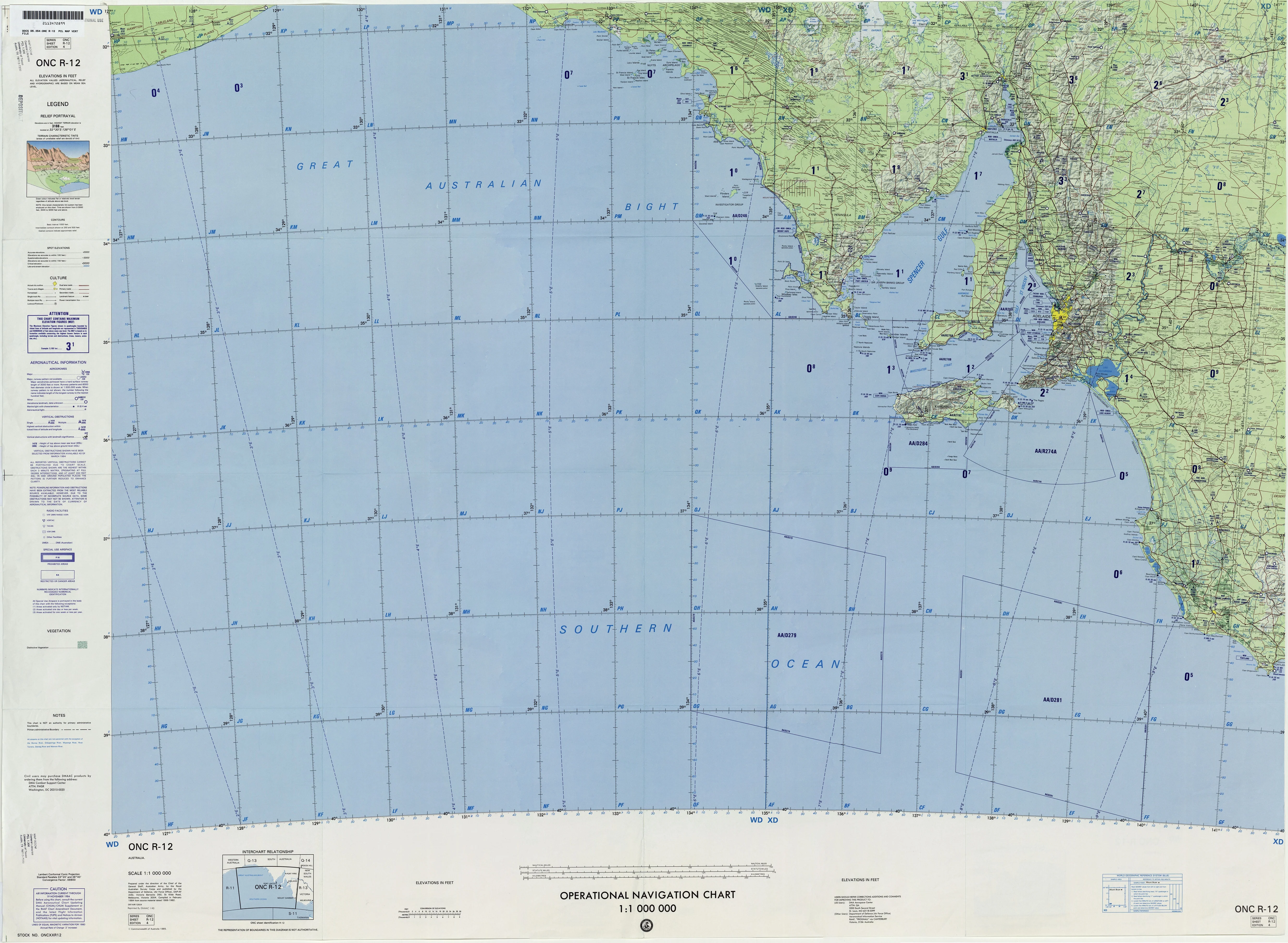
ONC Chart – Australia R-12
Size: 1000 mm x 735 mm
The ONC (Operational Navigation Chart) Australia R-12 provides a large-format, highly detailed overview of Australia’s R-12 sector, combining topographic accuracy with aeronautical reference data. Created at a scale of 1:1,000,000, this chart balances broad regional coverage with the detail needed for effective study, training, and display.
Designed originally for aeronautical use, the ONC R-12 chart incorporates towns, villages, pipelines, railroads, and road networks alongside natural landforms such as rivers, mountain ranges, deserts, and coastlines. Its precision and clarity make it a valuable tool for education, aviation history, and cartographic enthusiasts.
⚠ Important Note: This chart is NOT FOR NAVIGATIONAL USE. It is intended for educational, training, planning, and decorative applications only.
✈ Key Features
-
Topographic Accuracy – Detailed presentation of natural features such as rivers, mountains, deserts, and coastlines.
-
Aeronautical Data – Includes aviation-related information, offering insight into operational charting conventions.
-
Infrastructure Mapping – Depicts towns, villages, pipelines, railways, and roads.
-
Large-Format Presentation – Clear and engaging at 1:1,000,000 scale.
-
Versatile Use – Suitable for classrooms, aviation training centres, libraries, and professional offices.
📐 Technical Specifications
| Feature | Detail |
|---|---|
| Title | ONC Chart – Australia R-12 |
| Coverage | Australia – R-12 sector |
| Scale | 1:1,000,000 |
| Content | Topography, aeronautical data, towns, villages, pipelines, railways, roads |
| Use | Educational, planning, decorative, aviation study |
| Warning | Not for navigational use |
| Production | Printed in Australia |
🖼 Available Formats
This chart is available in five premium editions, ensuring flexibility for display and professional use:
📜 Paper Edition (160 gsm Premium Paper)
-
Printed on heavyweight 160 gsm paper.
-
Ideal for framing under glass.
-
Accessible and elegant—perfect for classrooms or collectors.
✨ Laminated Edition (80 Micron Gloss Encapsulation)
-
True encapsulation with two sheets of 80-micron gloss laminate.
-
Durable, wipe-clean, and tear-resistant.
-
Perfect for classrooms, offices, or planning spaces using whiteboard markers or map dots.
🖌 Canvas Edition (395 gsm Matte Canvas)
-
Printed on archival-grade 395 gsm HP Professional Matte Canvas with pigment inks.
-
Fade-resistant and richly textured, offering a classic gallery-quality appearance.
-
Designed to endure for decades.
🪵 Laminated with Hang Rails (Natural Timber)
-
Combines laminated protection with easy wall display.
-
Professionally mounted on natural timber hang rails, lacquered for durability.
-
Includes a strong hanging cord for effortless mounting.
🪵 Canvas with Hang Rails (Natural Timber)
-
The prestige edition: archival canvas paired with handcrafted timber hang rails.
-
Professionally mounted and lacquered.
-
A premium décor statement, ideal for executive offices, libraries, or collectors.
Note: Please allow up to 10 working days for delivery of hang-railed editions, as each one is custom-mounted by our framer.
🌏 Why Choose the ONC Chart – Australia R-12?
The ONC R-12 chart is more than a functional reference—it is a striking visual representation of Australia’s geography and aeronautical mapping history.
-
For Educators & Trainers – A valuable tool for explaining Australia’s physical and human geography.
-
For Aviation Enthusiasts – Provides historical insight into aeronautical cartography.
-
For Collectors & Historians – A distinctive chart with technical precision and aesthetic appeal.
-
For Professionals & Decorators – Adds a refined, technical dimension to offices, libraries, or study spaces.
-
For Analysts & Planners – Offers an integrated perspective on both infrastructure and natural geography.
The ONC Australia R-12 chart blends scientific accuracy with visual elegance, making it an enduring piece for study, reference, and display.
Original: $50.05
-65%$50.05
$17.52Product Information
Product Information
Shipping & Returns
Shipping & Returns
Description
ONC Chart – Australia R-12
Size: 1000 mm x 735 mm
The ONC (Operational Navigation Chart) Australia R-12 provides a large-format, highly detailed overview of Australia’s R-12 sector, combining topographic accuracy with aeronautical reference data. Created at a scale of 1:1,000,000, this chart balances broad regional coverage with the detail needed for effective study, training, and display.
Designed originally for aeronautical use, the ONC R-12 chart incorporates towns, villages, pipelines, railroads, and road networks alongside natural landforms such as rivers, mountain ranges, deserts, and coastlines. Its precision and clarity make it a valuable tool for education, aviation history, and cartographic enthusiasts.
⚠ Important Note: This chart is NOT FOR NAVIGATIONAL USE. It is intended for educational, training, planning, and decorative applications only.
✈ Key Features
-
Topographic Accuracy – Detailed presentation of natural features such as rivers, mountains, deserts, and coastlines.
-
Aeronautical Data – Includes aviation-related information, offering insight into operational charting conventions.
-
Infrastructure Mapping – Depicts towns, villages, pipelines, railways, and roads.
-
Large-Format Presentation – Clear and engaging at 1:1,000,000 scale.
-
Versatile Use – Suitable for classrooms, aviation training centres, libraries, and professional offices.
📐 Technical Specifications
| Feature | Detail |
|---|---|
| Title | ONC Chart – Australia R-12 |
| Coverage | Australia – R-12 sector |
| Scale | 1:1,000,000 |
| Content | Topography, aeronautical data, towns, villages, pipelines, railways, roads |
| Use | Educational, planning, decorative, aviation study |
| Warning | Not for navigational use |
| Production | Printed in Australia |
🖼 Available Formats
This chart is available in five premium editions, ensuring flexibility for display and professional use:
📜 Paper Edition (160 gsm Premium Paper)
-
Printed on heavyweight 160 gsm paper.
-
Ideal for framing under glass.
-
Accessible and elegant—perfect for classrooms or collectors.
✨ Laminated Edition (80 Micron Gloss Encapsulation)
-
True encapsulation with two sheets of 80-micron gloss laminate.
-
Durable, wipe-clean, and tear-resistant.
-
Perfect for classrooms, offices, or planning spaces using whiteboard markers or map dots.
🖌 Canvas Edition (395 gsm Matte Canvas)
-
Printed on archival-grade 395 gsm HP Professional Matte Canvas with pigment inks.
-
Fade-resistant and richly textured, offering a classic gallery-quality appearance.
-
Designed to endure for decades.
🪵 Laminated with Hang Rails (Natural Timber)
-
Combines laminated protection with easy wall display.
-
Professionally mounted on natural timber hang rails, lacquered for durability.
-
Includes a strong hanging cord for effortless mounting.
🪵 Canvas with Hang Rails (Natural Timber)
-
The prestige edition: archival canvas paired with handcrafted timber hang rails.
-
Professionally mounted and lacquered.
-
A premium décor statement, ideal for executive offices, libraries, or collectors.
Note: Please allow up to 10 working days for delivery of hang-railed editions, as each one is custom-mounted by our framer.
🌏 Why Choose the ONC Chart – Australia R-12?
The ONC R-12 chart is more than a functional reference—it is a striking visual representation of Australia’s geography and aeronautical mapping history.
-
For Educators & Trainers – A valuable tool for explaining Australia’s physical and human geography.
-
For Aviation Enthusiasts – Provides historical insight into aeronautical cartography.
-
For Collectors & Historians – A distinctive chart with technical precision and aesthetic appeal.
-
For Professionals & Decorators – Adds a refined, technical dimension to offices, libraries, or study spaces.
-
For Analysts & Planners – Offers an integrated perspective on both infrastructure and natural geography.
The ONC Australia R-12 chart blends scientific accuracy with visual elegance, making it an enduring piece for study, reference, and display.