ONC CHARTS AUSTRALIA R-13
ONC Chart – Australia R-13
Size: 1000 mm x 735 mm
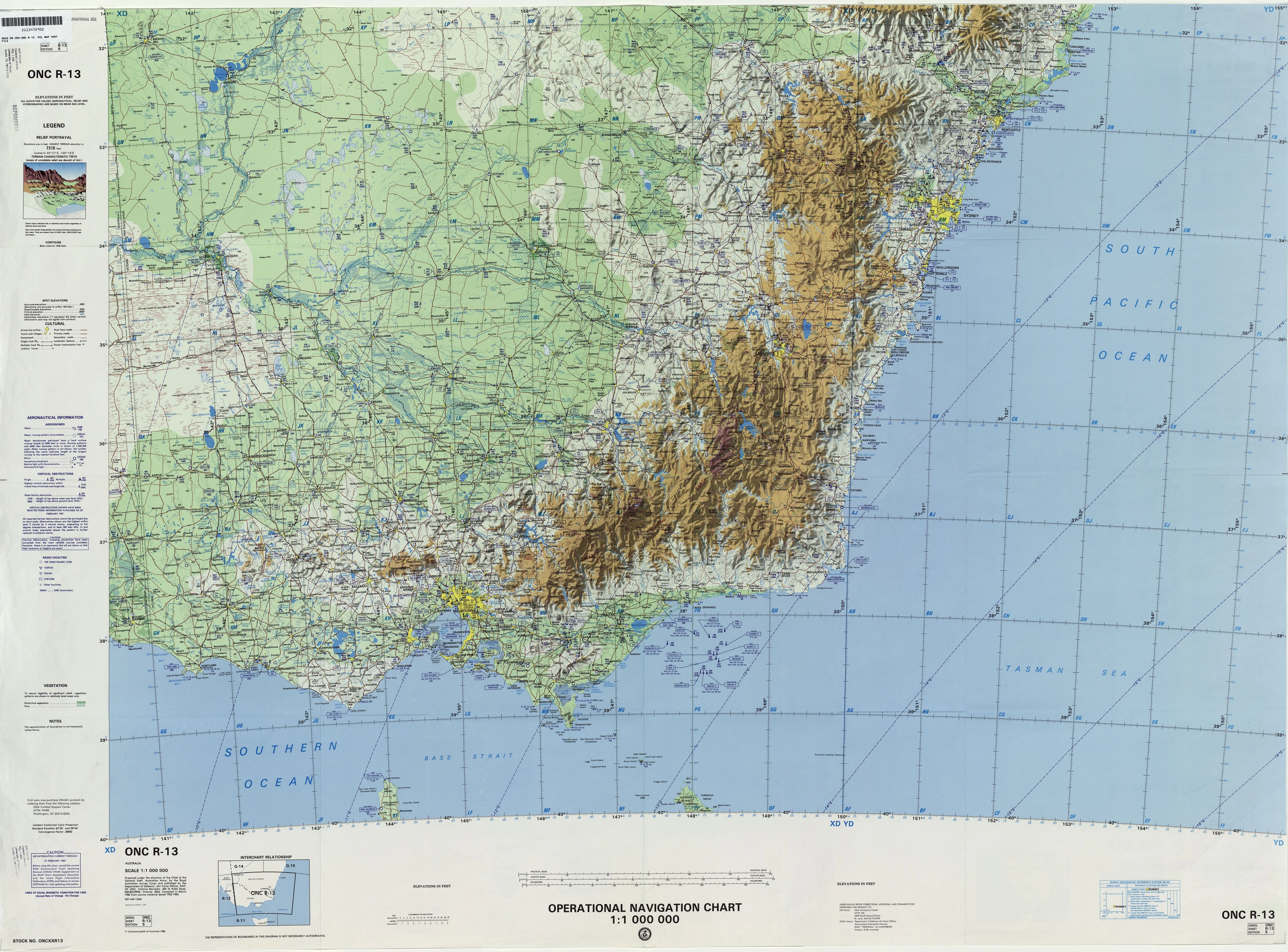
The ONC (Operational Navigation Chart) Australia R-13 provides a large-format overview of Australia’s R-13 sector, combining topographic data with aeronautical reference information. Produced at a scale of 1:1,000,000, this chart delivers a balanced mix of broad regional coverage and detailed landform and infrastructure mapping, making it a practical and visually impressive resource.
Originally created for aviation use, the ONC R-13 chart shows natural features such as rivers, mountain ranges, and deserts, alongside human infrastructure including towns, villages, pipelines, roads, and railways. This blend of cultural and physical data provides a clear and informative representation of the landscape.
⚠ Important Notice: This chart is supplied NOT FOR NAVIGATIONAL USE. It is intended for educational, decorative, planning, and training applications only.
✈ Key Features
-
Topographic Accuracy – Depicts rivers, mountains, deserts, and coastlines with clarity.
-
Aeronautical Data – Includes aviation-related references for insight into ONC mapping methods.
-
Infrastructure Mapping – Shows towns, villages, pipelines, railways, and road systems.
-
Large-Format Scale – At 1:1,000,000, offers strong visual clarity with broad coverage.
-
Multi-Purpose Utility – Ideal for classrooms, aviation training, libraries, offices, or collectors.
📐 Technical Specifications
| Feature | Detail |
|---|---|
| Title | ONC Chart – Australia R-13 |
| Coverage | Australia – R-13 sector |
| Scale | 1:1,000,000 |
| Content | Topography, aeronautical references, towns, villages, pipelines, railways, roads |
| Use | Educational, decorative, training, planning |
| Warning | Not for navigational use |
| Production | Printed in Australia |
🖼 Available Formats
This chart is available in five premium formats, each designed for a different environment or use case:
📜 Paper Edition (160 gsm Premium Paper)
-
Printed on heavyweight 160 gsm paper.
-
Perfect for framing under glass in a traditional setting.
-
Elegant and accessible—suitable for classrooms or collectors.
✨ Laminated Edition (80 Micron Gloss Encapsulation)
-
Fully encapsulated in 80-micron gloss laminate.
-
Durable, wipe-clean, and tear-resistant.
-
Excellent for schools, offices, and planning rooms—use with map dots or whiteboard markers.
🖌 Canvas Edition (395 gsm Matte Canvas)
-
Printed on archival-grade 395 gsm HP Professional Matte Canvas with pigment inks.
-
Fade-resistant, richly textured, and gallery-quality.
-
Designed to last for decades as both a decorative and functional chart.
🪵 Laminated with Hang Rails (Natural Timber)
-
Combines laminated protection with a professional hanging solution.
-
Mounted on lacquered natural timber rails, top and bottom.
-
Includes a strong cord for effortless wall display.
🪵 Canvas with Hang Rails (Natural Timber)
-
The prestige choice: archival canvas with handcrafted timber hang rails.
-
Professionally mounted and lacquered for a refined finish.
-
A statement décor piece, ideal for executive offices, libraries, and collectors.
Note: Please allow up to 10 working days for delivery of hang-railed editions, as these are custom-mounted by our professional framer.
🌏 Why Choose the ONC Chart – Australia R-13?
The ONC R-13 chart provides more than just data—it offers a window into the precision of aviation cartography, making it an exceptional tool for:
-
Educators & Trainers – Demonstrating the integration of geography and aeronautics.
-
Aviation Enthusiasts – Preserving a piece of operational charting history.
-
Collectors & Historians – An authentic technical artefact with lasting visual appeal.
-
Offices & Libraries – Adds a refined technical and geographical dimension to interiors.
-
Analysts & Planners – A comprehensive overview of infrastructure and landforms.
Blending scientific precision with aesthetic presentation, the ONC Australia R-13 stands as both a functional reference tool and a striking display piece.
Original: $50.05
-65%$50.05
$17.52Product Information
Product Information
Shipping & Returns
Shipping & Returns
Description
ONC Chart – Australia R-13
Size: 1000 mm x 735 mm
The ONC (Operational Navigation Chart) Australia R-13 provides a large-format overview of Australia’s R-13 sector, combining topographic data with aeronautical reference information. Produced at a scale of 1:1,000,000, this chart delivers a balanced mix of broad regional coverage and detailed landform and infrastructure mapping, making it a practical and visually impressive resource.
Originally created for aviation use, the ONC R-13 chart shows natural features such as rivers, mountain ranges, and deserts, alongside human infrastructure including towns, villages, pipelines, roads, and railways. This blend of cultural and physical data provides a clear and informative representation of the landscape.
⚠ Important Notice: This chart is supplied NOT FOR NAVIGATIONAL USE. It is intended for educational, decorative, planning, and training applications only.
✈ Key Features
-
Topographic Accuracy – Depicts rivers, mountains, deserts, and coastlines with clarity.
-
Aeronautical Data – Includes aviation-related references for insight into ONC mapping methods.
-
Infrastructure Mapping – Shows towns, villages, pipelines, railways, and road systems.
-
Large-Format Scale – At 1:1,000,000, offers strong visual clarity with broad coverage.
-
Multi-Purpose Utility – Ideal for classrooms, aviation training, libraries, offices, or collectors.
📐 Technical Specifications
| Feature | Detail |
|---|---|
| Title | ONC Chart – Australia R-13 |
| Coverage | Australia – R-13 sector |
| Scale | 1:1,000,000 |
| Content | Topography, aeronautical references, towns, villages, pipelines, railways, roads |
| Use | Educational, decorative, training, planning |
| Warning | Not for navigational use |
| Production | Printed in Australia |
🖼 Available Formats
This chart is available in five premium formats, each designed for a different environment or use case:
📜 Paper Edition (160 gsm Premium Paper)
-
Printed on heavyweight 160 gsm paper.
-
Perfect for framing under glass in a traditional setting.
-
Elegant and accessible—suitable for classrooms or collectors.
✨ Laminated Edition (80 Micron Gloss Encapsulation)
-
Fully encapsulated in 80-micron gloss laminate.
-
Durable, wipe-clean, and tear-resistant.
-
Excellent for schools, offices, and planning rooms—use with map dots or whiteboard markers.
🖌 Canvas Edition (395 gsm Matte Canvas)
-
Printed on archival-grade 395 gsm HP Professional Matte Canvas with pigment inks.
-
Fade-resistant, richly textured, and gallery-quality.
-
Designed to last for decades as both a decorative and functional chart.
🪵 Laminated with Hang Rails (Natural Timber)
-
Combines laminated protection with a professional hanging solution.
-
Mounted on lacquered natural timber rails, top and bottom.
-
Includes a strong cord for effortless wall display.
🪵 Canvas with Hang Rails (Natural Timber)
-
The prestige choice: archival canvas with handcrafted timber hang rails.
-
Professionally mounted and lacquered for a refined finish.
-
A statement décor piece, ideal for executive offices, libraries, and collectors.
Note: Please allow up to 10 working days for delivery of hang-railed editions, as these are custom-mounted by our professional framer.
🌏 Why Choose the ONC Chart – Australia R-13?
The ONC R-13 chart provides more than just data—it offers a window into the precision of aviation cartography, making it an exceptional tool for:
-
Educators & Trainers – Demonstrating the integration of geography and aeronautics.
-
Aviation Enthusiasts – Preserving a piece of operational charting history.
-
Collectors & Historians – An authentic technical artefact with lasting visual appeal.
-
Offices & Libraries – Adds a refined technical and geographical dimension to interiors.
-
Analysts & Planners – A comprehensive overview of infrastructure and landforms.
Blending scientific precision with aesthetic presentation, the ONC Australia R-13 stands as both a functional reference tool and a striking display piece.