Ontario Canada - Published 1978 by National Geographic
Travel & Recreation Wall Map | Parks, Wilderness & Cities | 833 × 573 mm | Premium Finishes
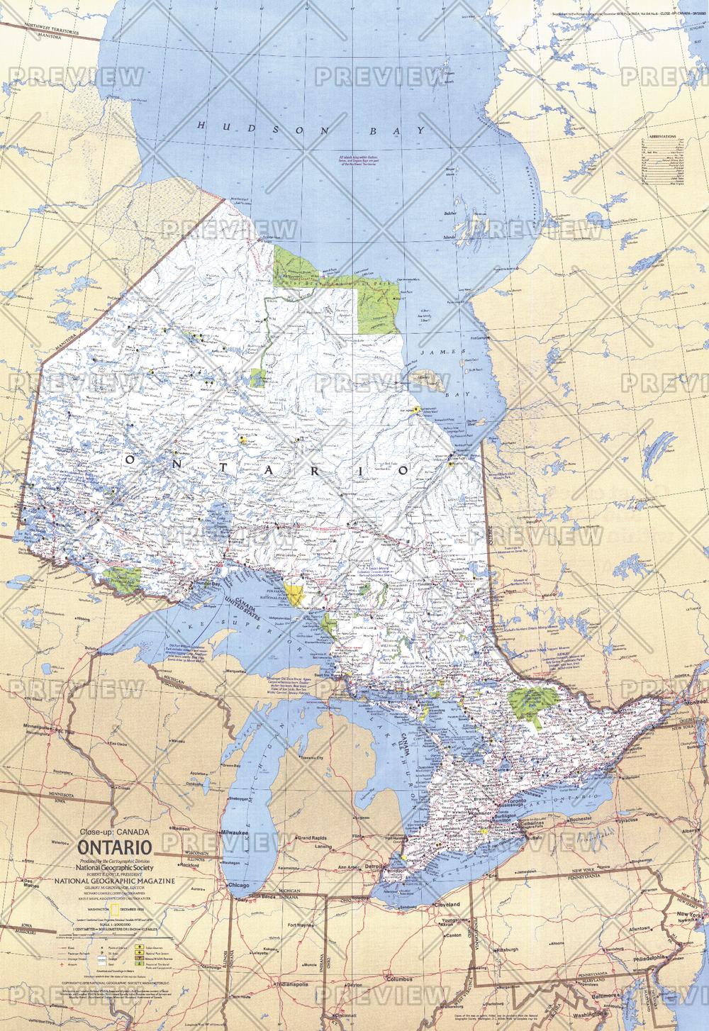
A richly detailed travel map of one of Canada’s most diverse provinces, Ontario brings together vast wilderness and vibrant urban centres in a single, beautifully balanced composition. Published by National Geographic in December 1978, this map is designed for exploration—highlighting the natural landscapes and destinations that define Ontario.
From forested parks and lakeside campgrounds to the cultural hubs of Toronto and Ottawa, it offers a complete snapshot of the province as both a destination and a landscape.
Why This Map Stands Out
A traveller’s overview of Ontario
Combines natural attractions with key urban highlights.
Park and wilderness focus
Showcases national parks, protected areas, and campgrounds.
Classic National Geographic style
Clear, vibrant cartography from a trusted source.
Balanced regional coverage
Connects remote landscapes with major population centres.
A versatile wall map
Ideal for planning, reference, or display.
🗺️ What the Map Shows
- The full extent of Ontario, including:
- Major lakes, rivers, and forested regions
- Hundreds of national parks, wilderness areas, and campgrounds
- Cities and points of interest, including:
- Toronto
- Ottawa
- Transport routes and regional connections
- A framework linking travel, recreation, and geography
📐 Size & Format
833 mm (H) × 573 mm (W)
Portrait orientation
A large, display-ready format ideal for:
- Travel planning spaces
- Home offices and studies
- Classrooms and geography education
- Interiors with a nature or adventure theme
✨ Premium Finishes
| Format | Description |
|---|---|
| 📜 Paper (160 gsm) | Heavyweight matte-coated paper—ideal for framing. Preserves fine detail and colour. |
| 🧼 Laminated (True Encapsulation) | 2 × 80-micron gloss laminate. Durable, wipe-clean, and perfect for travel planning. |
| 🪵 Laminated + Timber Hang Rails | Ready-to-hang with lacquered natural timber rails. Allow up to 10 working days. |
| 🖼️ Archival Canvas (395 gsm HP Professional Matte) | Museum-grade finish with pigment-based, fade-resistant inks. |
| 🪵 Canvas + Timber Hang Rails | Gallery-ready presentation. Allow up to 10 working days. |
📊 Specifications
| Feature | Detail |
|---|---|
| Title | Ontario, Canada |
| Publisher | National Geographic |
| Published | 1978 |
| Dimensions | 833 mm × 573 mm |
| Orientation | Portrait |
| Map Type | Travel / Regional |
| Coverage | Ontario, Canada |
| Collections | North America, Historical |
| Materials | 160 gsm matte paper · 2 × 80-micron laminate · 395 gsm HP Professional Matte Canvas |
| Inks | Pigment-based, fade-resistant |
| Origin | Printed in Australia |
🎯 Ideal For
- Travellers planning trips across Ontario’s parks and regions
- Outdoor enthusiasts and campers
- Collectors of National Geographic travel maps
- Interiors seeking a nature-inspired display piece
- Gift buyers looking for a practical and scenic map
🌲 A Province of Scale and Variety
Ontario offers:
- Vast forests and freshwater systems
- Iconic national and provincial parks
- A network of campgrounds and outdoor destinations
- Dynamic cities balancing nature and culture
This map captures that diversity—offering a clear and inviting view of a province where wilderness and urban life exist side by side.
🤝 Our Commitment
- Printed in Australia using archival-quality materials
- Faithfully reproduced to preserve clarity and colour
- Premium finishes designed for long-term display
- Each map is hand-checked and carefully packed
🚚 Delivery
- Rolled (Paper, Laminated, Canvas): Dispatch within 1–2 business days
- Hang-Railed Finishes: Made to order — allow up to 10 working days
Plan the journey or relive the landscape—
a map that brings Ontario’s parks, cities, and wilderness into focus.
Product Information
Product Information
Shipping & Returns
Shipping & Returns
Description
Travel & Recreation Wall Map | Parks, Wilderness & Cities | 833 × 573 mm | Premium Finishes
A richly detailed travel map of one of Canada’s most diverse provinces, Ontario brings together vast wilderness and vibrant urban centres in a single, beautifully balanced composition. Published by National Geographic in December 1978, this map is designed for exploration—highlighting the natural landscapes and destinations that define Ontario.
From forested parks and lakeside campgrounds to the cultural hubs of Toronto and Ottawa, it offers a complete snapshot of the province as both a destination and a landscape.
Why This Map Stands Out
A traveller’s overview of Ontario
Combines natural attractions with key urban highlights.
Park and wilderness focus
Showcases national parks, protected areas, and campgrounds.
Classic National Geographic style
Clear, vibrant cartography from a trusted source.
Balanced regional coverage
Connects remote landscapes with major population centres.
A versatile wall map
Ideal for planning, reference, or display.
🗺️ What the Map Shows
- The full extent of Ontario, including:
- Major lakes, rivers, and forested regions
- Hundreds of national parks, wilderness areas, and campgrounds
- Cities and points of interest, including:
- Toronto
- Ottawa
- Transport routes and regional connections
- A framework linking travel, recreation, and geography
📐 Size & Format
833 mm (H) × 573 mm (W)
Portrait orientation
A large, display-ready format ideal for:
- Travel planning spaces
- Home offices and studies
- Classrooms and geography education
- Interiors with a nature or adventure theme
✨ Premium Finishes
| Format | Description |
|---|---|
| 📜 Paper (160 gsm) | Heavyweight matte-coated paper—ideal for framing. Preserves fine detail and colour. |
| 🧼 Laminated (True Encapsulation) | 2 × 80-micron gloss laminate. Durable, wipe-clean, and perfect for travel planning. |
| 🪵 Laminated + Timber Hang Rails | Ready-to-hang with lacquered natural timber rails. Allow up to 10 working days. |
| 🖼️ Archival Canvas (395 gsm HP Professional Matte) | Museum-grade finish with pigment-based, fade-resistant inks. |
| 🪵 Canvas + Timber Hang Rails | Gallery-ready presentation. Allow up to 10 working days. |
📊 Specifications
| Feature | Detail |
|---|---|
| Title | Ontario, Canada |
| Publisher | National Geographic |
| Published | 1978 |
| Dimensions | 833 mm × 573 mm |
| Orientation | Portrait |
| Map Type | Travel / Regional |
| Coverage | Ontario, Canada |
| Collections | North America, Historical |
| Materials | 160 gsm matte paper · 2 × 80-micron laminate · 395 gsm HP Professional Matte Canvas |
| Inks | Pigment-based, fade-resistant |
| Origin | Printed in Australia |
🎯 Ideal For
- Travellers planning trips across Ontario’s parks and regions
- Outdoor enthusiasts and campers
- Collectors of National Geographic travel maps
- Interiors seeking a nature-inspired display piece
- Gift buyers looking for a practical and scenic map
🌲 A Province of Scale and Variety
Ontario offers:
- Vast forests and freshwater systems
- Iconic national and provincial parks
- A network of campgrounds and outdoor destinations
- Dynamic cities balancing nature and culture
This map captures that diversity—offering a clear and inviting view of a province where wilderness and urban life exist side by side.
🤝 Our Commitment
- Printed in Australia using archival-quality materials
- Faithfully reproduced to preserve clarity and colour
- Premium finishes designed for long-term display
- Each map is hand-checked and carefully packed
🚚 Delivery
- Rolled (Paper, Laminated, Canvas): Dispatch within 1–2 business days
- Hang-Railed Finishes: Made to order — allow up to 10 working days
Plan the journey or relive the landscape—
a map that brings Ontario’s parks, cities, and wilderness into focus.


