Ontario Great Cities Wilds Within Reach - Published 1978 by National Geographic
Making of Canada Style Feature | Urban Energy & Wilderness Access | Historical Wall Map | 833 × 573 mm | Premium Finishes
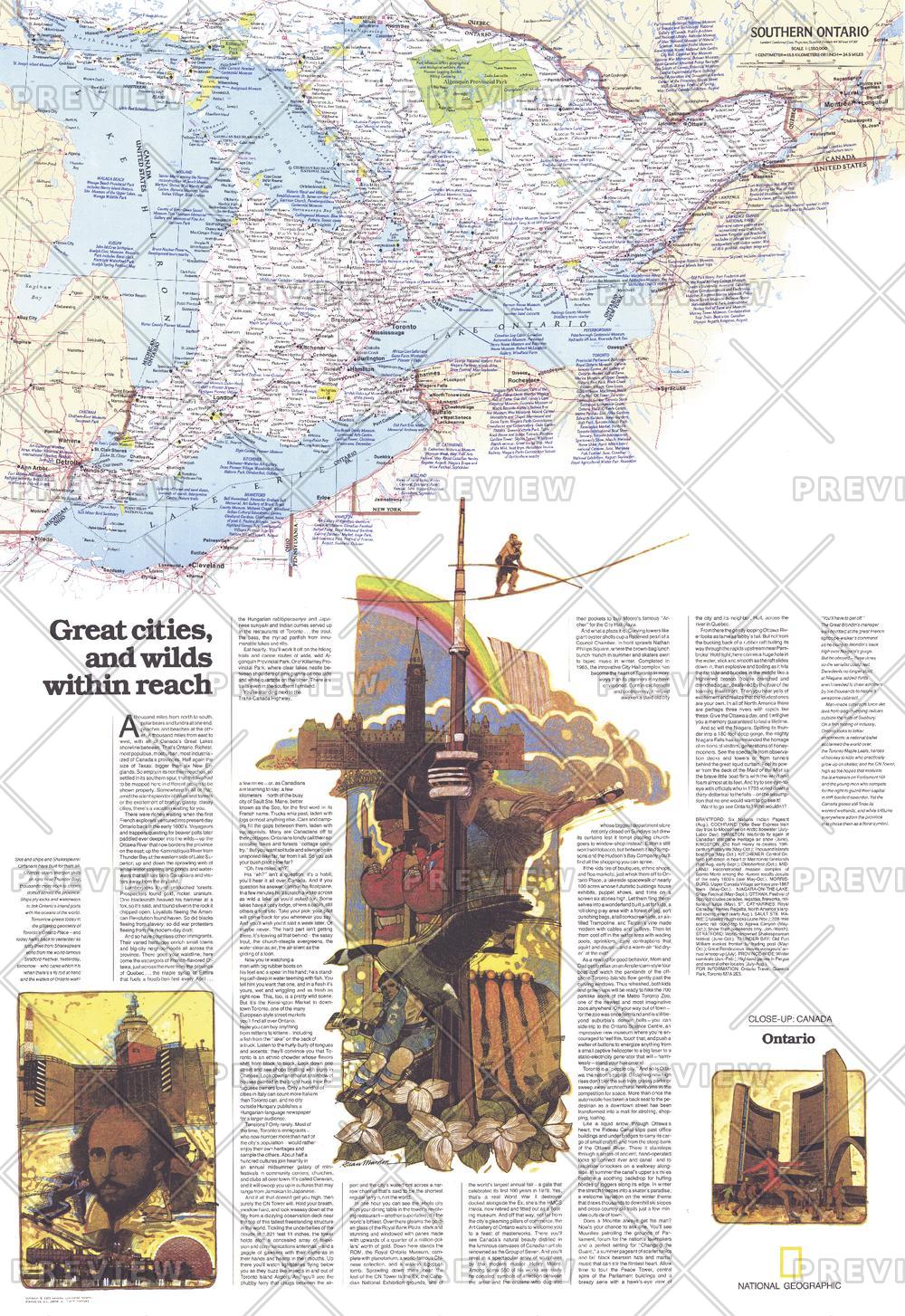
A province of contrasts brought into perfect balance, Ontario: Great Cities, Wilds Within Reach captures the unique character of Ontario—where vibrant urban centres sit within easy reach of vast natural landscapes. Published by National Geographic in December 1978, this map forms one half of a two-map set accompanying the feature article “Ontario, Canada’s Keystone.”
It’s a map that tells a broader story: how industry, culture, and wilderness coexist in one of Canada’s most dynamic regions.
Why This Map Stands Out
A province of contrasts
Balances major cities with accessible wilderness regions.
Part of a two-map set
Designed to complement a companion map for a complete overview.
Richly informative
Packed with geographic, cultural, and economic insights.
Classic National Geographic design
Clear, engaging, and visually compelling.
A strong wall presence
Large format ideal for both study and display.
🗺️ What the Map Shows
- The province of Ontario in detail, including:
- Major population centres such as Toronto and Ottawa
- Urban networks and industrial regions shaping the province’s economy
- Surrounding natural landscapes, including forests, lakes, and protected areas
- Travel routes and connections linking cities to wilderness areas
- A geographic framework highlighting the idea of “wilds within reach”
🌆🌲 Cities and Wilderness, Side by Side
Ontario’s identity lies in its balance:
- Dynamic, growing cities driving culture and industry
- Expansive wilderness offering recreation and escape
- Transport networks connecting urban life with natural spaces
- A province where nature is never far from reach
This map captures that relationship—showing how modern life and natural landscapes coexist and connect.
📐 Size & Format
833 mm (H) × 573 mm (W)
Portrait orientation
A bold, vertical format ideal for:
- Offices and planning spaces
- Classrooms and geography education
- Home studies and libraries
- Interiors seeking a balanced urban–nature theme
✨ Premium Finishes
| Format | Description |
|---|---|
| 📜 Paper (160 gsm) | Heavyweight matte-coated paper—ideal for framing. Preserves clarity and detail. |
| 🧼 Laminated (True Encapsulation) | 2 × 80-micron gloss laminate. Durable, wipe-clean, and perfect for reference use. |
| 🪵 Laminated + Timber Hang Rails | Ready-to-hang with lacquered natural timber rails. Allow up to 10 working days. |
| 🖼️ Archival Canvas (395 gsm HP Professional Matte) | Museum-grade finish with pigment-based, fade-resistant inks. |
| 🪵 Canvas + Timber Hang Rails | Gallery-ready presentation. Allow up to 10 working days. |
📊 Specifications
| Feature | Detail |
|---|---|
| Title | Ontario: Great Cities, Wilds Within Reach |
| Publisher | National Geographic |
| Published | 1978 |
| Dimensions | 833 mm × 573 mm |
| Orientation | Portrait |
| Map Type | Historical / Regional |
| Coverage | Ontario, Canada |
| Collections | North America, Historical |
| Materials | 160 gsm matte paper · 2 × 80-micron laminate · 395 gsm HP Professional Matte Canvas |
| Inks | Pigment-based, fade-resistant |
| Origin | Printed in Australia |
🎯 Ideal For
- Students and educators of Canadian geography and regional development
- Travellers exploring Ontario’s cities and wilderness areas
- Collectors of National Geographic historical maps
- Interiors seeking a balanced, narrative-driven display piece
- Gift buyers looking for a map with both beauty and insight
🌍 Canada’s Keystone Province
Ontario stands as:
- Canada’s economic and industrial core
- A gateway between east and west
- A landscape of lakes, forests, and natural beauty
- A region where access to wilderness remains part of everyday life
This map reflects that identity—offering a clear and compelling view of a province where urban energy and natural escape exist in perfect tension.
🤝 Our Commitment
- Printed in Australia using archival-quality materials
- Faithfully reproduced to preserve clarity and colour
- Premium finishes designed for long-term display
- Each map is hand-checked and carefully packed
🚚 Delivery
- Rolled (Paper, Laminated, Canvas): Dispatch within 1–2 business days
- Hang-Railed Finishes: Made to order — allow up to 10 working days
Discover the balance of city and wilderness—
a map that captures Ontario at its most dynamic and diverse.
Product Information
Product Information
Shipping & Returns
Shipping & Returns
Description
Making of Canada Style Feature | Urban Energy & Wilderness Access | Historical Wall Map | 833 × 573 mm | Premium Finishes
A province of contrasts brought into perfect balance, Ontario: Great Cities, Wilds Within Reach captures the unique character of Ontario—where vibrant urban centres sit within easy reach of vast natural landscapes. Published by National Geographic in December 1978, this map forms one half of a two-map set accompanying the feature article “Ontario, Canada’s Keystone.”
It’s a map that tells a broader story: how industry, culture, and wilderness coexist in one of Canada’s most dynamic regions.
Why This Map Stands Out
A province of contrasts
Balances major cities with accessible wilderness regions.
Part of a two-map set
Designed to complement a companion map for a complete overview.
Richly informative
Packed with geographic, cultural, and economic insights.
Classic National Geographic design
Clear, engaging, and visually compelling.
A strong wall presence
Large format ideal for both study and display.
🗺️ What the Map Shows
- The province of Ontario in detail, including:
- Major population centres such as Toronto and Ottawa
- Urban networks and industrial regions shaping the province’s economy
- Surrounding natural landscapes, including forests, lakes, and protected areas
- Travel routes and connections linking cities to wilderness areas
- A geographic framework highlighting the idea of “wilds within reach”
🌆🌲 Cities and Wilderness, Side by Side
Ontario’s identity lies in its balance:
- Dynamic, growing cities driving culture and industry
- Expansive wilderness offering recreation and escape
- Transport networks connecting urban life with natural spaces
- A province where nature is never far from reach
This map captures that relationship—showing how modern life and natural landscapes coexist and connect.
📐 Size & Format
833 mm (H) × 573 mm (W)
Portrait orientation
A bold, vertical format ideal for:
- Offices and planning spaces
- Classrooms and geography education
- Home studies and libraries
- Interiors seeking a balanced urban–nature theme
✨ Premium Finishes
| Format | Description |
|---|---|
| 📜 Paper (160 gsm) | Heavyweight matte-coated paper—ideal for framing. Preserves clarity and detail. |
| 🧼 Laminated (True Encapsulation) | 2 × 80-micron gloss laminate. Durable, wipe-clean, and perfect for reference use. |
| 🪵 Laminated + Timber Hang Rails | Ready-to-hang with lacquered natural timber rails. Allow up to 10 working days. |
| 🖼️ Archival Canvas (395 gsm HP Professional Matte) | Museum-grade finish with pigment-based, fade-resistant inks. |
| 🪵 Canvas + Timber Hang Rails | Gallery-ready presentation. Allow up to 10 working days. |
📊 Specifications
| Feature | Detail |
|---|---|
| Title | Ontario: Great Cities, Wilds Within Reach |
| Publisher | National Geographic |
| Published | 1978 |
| Dimensions | 833 mm × 573 mm |
| Orientation | Portrait |
| Map Type | Historical / Regional |
| Coverage | Ontario, Canada |
| Collections | North America, Historical |
| Materials | 160 gsm matte paper · 2 × 80-micron laminate · 395 gsm HP Professional Matte Canvas |
| Inks | Pigment-based, fade-resistant |
| Origin | Printed in Australia |
🎯 Ideal For
- Students and educators of Canadian geography and regional development
- Travellers exploring Ontario’s cities and wilderness areas
- Collectors of National Geographic historical maps
- Interiors seeking a balanced, narrative-driven display piece
- Gift buyers looking for a map with both beauty and insight
🌍 Canada’s Keystone Province
Ontario stands as:
- Canada’s economic and industrial core
- A gateway between east and west
- A landscape of lakes, forests, and natural beauty
- A region where access to wilderness remains part of everyday life
This map reflects that identity—offering a clear and compelling view of a province where urban energy and natural escape exist in perfect tension.
🤝 Our Commitment
- Printed in Australia using archival-quality materials
- Faithfully reproduced to preserve clarity and colour
- Premium finishes designed for long-term display
- Each map is hand-checked and carefully packed
🚚 Delivery
- Rolled (Paper, Laminated, Canvas): Dispatch within 1–2 business days
- Hang-Railed Finishes: Made to order — allow up to 10 working days
Discover the balance of city and wilderness—
a map that captures Ontario at its most dynamic and diverse.


