Oregon by National Geographic
Physical Wall Map | Terrain, Trails & Infrastructure | Large Format (1029 × 768 mm) | Premium Finishes
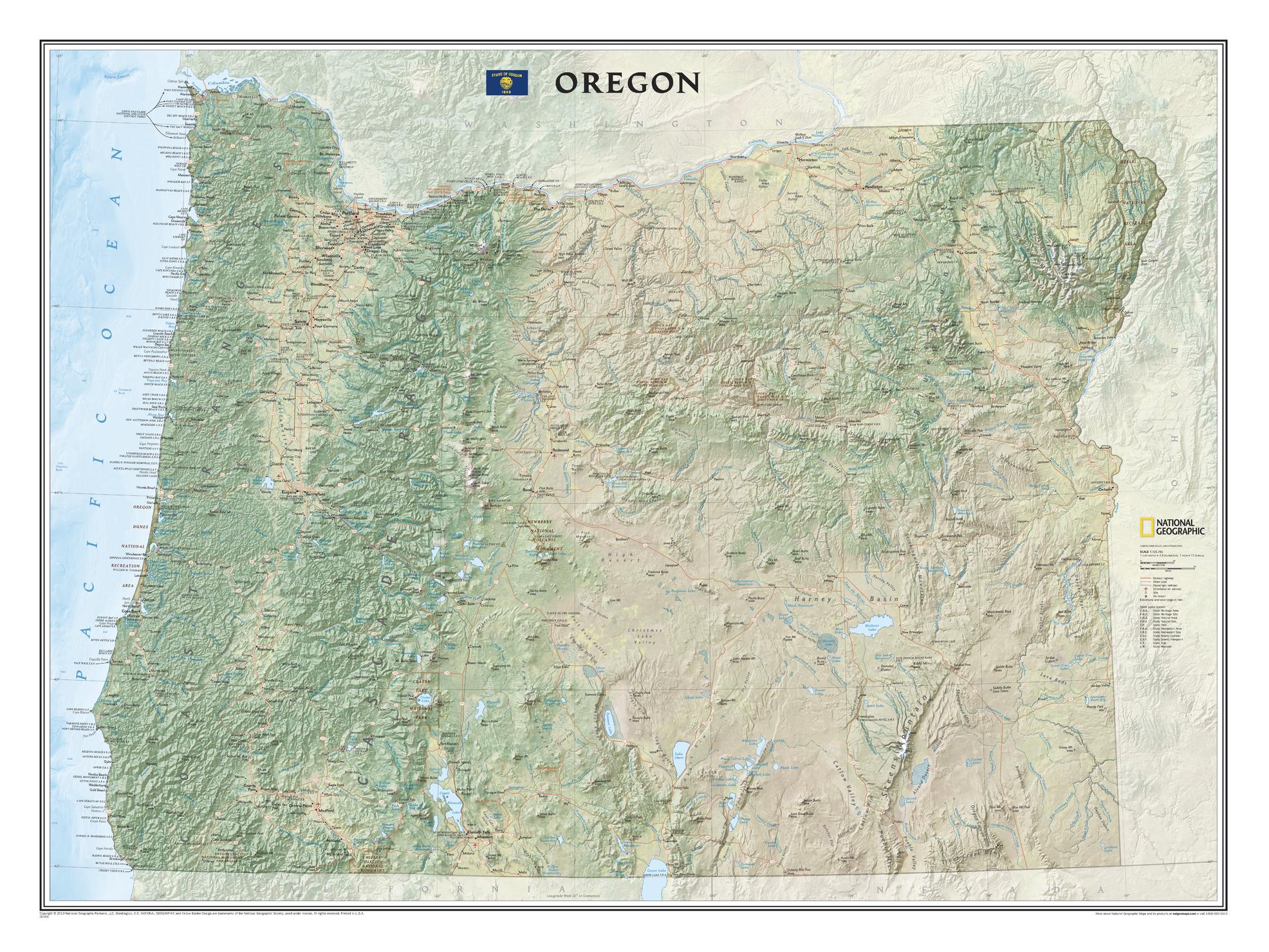
A commanding, richly detailed portrait of the Pacific Northwest, Oregon brings one of America’s most geographically diverse states into vivid focus. Produced by National Geographic, this large-format wall map combines precision cartography, refined colour work, and beautifully sculpted shaded relief to reveal the full character of Oregon.
From the Pacific coastline to volcanic peaks and high desert plateaus, this is a map designed not just to inform—but to immerse.
Why This Map Stands Out
Exceptional terrain realism
Detailed shaded relief gives depth to mountains, valleys, and basins.
Comprehensive geographic coverage
Natural features, infrastructure, and recreation all in one map.
Adventure-ready detail
Highlights parks, trails, and destinations for outdoor exploration.
Large-format clarity
Generous size ensures readability from across the room.
National Geographic authority
Decades of cartographic expertise distilled into one refined piece.
🗺️ What the Map Shows
⛰️ Physical Landscape
- Major mountain systems including the Cascades and volcanic peaks
- Prominent summits, ridgelines, and high-altitude terrain
- Rivers, lakes, reservoirs, and watershed systems
- Coastal zones, forest regions, valleys, and desert interiors
🌲 Natural Regions in Contrast
- Lush coastal forests and temperate rainforests
- Fertile valleys such as the Willamette Basin
- Arid high desert landscapes to the east
- Dramatic transitions between ecosystems across the state
🏙️ Cities & Infrastructure
- Cities and towns positioned with precision
- Major highways, regional roads, and transport corridors
- Rail networks and key airports
- A clear sense of how geography shapes settlement and movement
🏞️ Parks & Recreation
- National and state parks across Oregon
- Protected wilderness areas and recreation zones
- The route of the iconic Pacific Crest Trail traversing the state from south to north
- A framework for planning travel, hiking, and outdoor exploration
🌄 A Landscape of Extremes
Oregon is a state defined by contrast:
- Snow-covered volcanoes rising above forested slopes
- Deep river valleys cutting through rugged terrain
- Vast interior deserts stretching toward the horizon
- A coastline shaped by the relentless Pacific
This map captures that diversity—showing how climate, geology, and elevation combine to create one of North America’s most varied landscapes.
📐 Size & Format
1029 mm (W) × 768 mm (H)
Landscape orientation (large format)
A bold, wall-dominating size ideal for:
- Feature walls in offices and meeting rooms
- Planning environments and logistics spaces
- Classrooms and geography departments
- Home libraries and curated interiors
✨ Premium Finishes
| Format | Description |
|---|---|
| 📜 Heavyweight Paper (160 gsm matte) | Archival-quality, low-glare finish—ideal for framing under glass. |
| 🧼 Laminated (True Encapsulation) | 2 × 80-micron gloss laminate, edge-sealed. Durable, wipe-clean, and suitable for map dots and whiteboard markers. |
| 🪵 Laminated + Timber Hang Rails | Ready-to-hang with lacquered natural timber rails and cord. Allow up to 10 working days. |
| 🖼️ Archival Canvas (395 gsm HP Professional Matte) | Museum-grade finish with pigment-based, fade-resistant inks for depth and longevity. |
| 🪵 Canvas + Timber Hang Rails | Gallery-ready presentation. Allow up to 10 working days. |
📊 Specifications
| Feature | Detail |
|---|---|
| Title | Oregon |
| Publisher | National Geographic |
| Published | 2019 |
| Scale | 1:725,765 |
| Dimensions | 1029 mm × 768 mm |
| Orientation | Landscape |
| Map Type | Physical |
| Coverage | Oregon, USA |
| Collections | USA, Physical |
| Materials | 160 gsm matte paper · 2 × 80-micron laminate · 395 gsm HP Professional Matte Canvas |
| Inks | Pigment-based, fade-resistant |
| Origin | Printed in Australia |
🎯 Ideal For
- Outdoor enthusiasts planning hiking, camping, and exploration
- Students and educators studying physical geography and landscapes
- Travellers mapping routes across the Pacific Northwest
- Collectors of National Geographic wall maps
- Interiors seeking a large, nature-driven statement piece
🧭 More Than a Map—A Planning Tool
Whether you’re:
- Mapping a road trip across the state
- Tracing hiking routes through mountain ranges
- Understanding watershed systems and terrain
- Or simply appreciating the beauty of the landscape
This map provides both big-picture clarity and fine-detail insight.
🤝 Our Commitment
- Printed in Australia using archival-quality materials
- Faithfully reproduced to preserve colour, clarity, and terrain detail
- Premium finishes designed for long-term display
- Each map is hand-checked and carefully packed
🚚 Delivery
- Rolled (Paper, Laminated, Canvas): Dispatch within 1–2 business days
- Hang-Railed Finishes: Made to order — allow up to 10 working days
Explore every ridge, river, and road—
a map that brings Oregon’s landscapes to life at full scale.
Product Information
Product Information
Shipping & Returns
Shipping & Returns
Description
Physical Wall Map | Terrain, Trails & Infrastructure | Large Format (1029 × 768 mm) | Premium Finishes
A commanding, richly detailed portrait of the Pacific Northwest, Oregon brings one of America’s most geographically diverse states into vivid focus. Produced by National Geographic, this large-format wall map combines precision cartography, refined colour work, and beautifully sculpted shaded relief to reveal the full character of Oregon.
From the Pacific coastline to volcanic peaks and high desert plateaus, this is a map designed not just to inform—but to immerse.
Why This Map Stands Out
Exceptional terrain realism
Detailed shaded relief gives depth to mountains, valleys, and basins.
Comprehensive geographic coverage
Natural features, infrastructure, and recreation all in one map.
Adventure-ready detail
Highlights parks, trails, and destinations for outdoor exploration.
Large-format clarity
Generous size ensures readability from across the room.
National Geographic authority
Decades of cartographic expertise distilled into one refined piece.
🗺️ What the Map Shows
⛰️ Physical Landscape
- Major mountain systems including the Cascades and volcanic peaks
- Prominent summits, ridgelines, and high-altitude terrain
- Rivers, lakes, reservoirs, and watershed systems
- Coastal zones, forest regions, valleys, and desert interiors
🌲 Natural Regions in Contrast
- Lush coastal forests and temperate rainforests
- Fertile valleys such as the Willamette Basin
- Arid high desert landscapes to the east
- Dramatic transitions between ecosystems across the state
🏙️ Cities & Infrastructure
- Cities and towns positioned with precision
- Major highways, regional roads, and transport corridors
- Rail networks and key airports
- A clear sense of how geography shapes settlement and movement
🏞️ Parks & Recreation
- National and state parks across Oregon
- Protected wilderness areas and recreation zones
- The route of the iconic Pacific Crest Trail traversing the state from south to north
- A framework for planning travel, hiking, and outdoor exploration
🌄 A Landscape of Extremes
Oregon is a state defined by contrast:
- Snow-covered volcanoes rising above forested slopes
- Deep river valleys cutting through rugged terrain
- Vast interior deserts stretching toward the horizon
- A coastline shaped by the relentless Pacific
This map captures that diversity—showing how climate, geology, and elevation combine to create one of North America’s most varied landscapes.
📐 Size & Format
1029 mm (W) × 768 mm (H)
Landscape orientation (large format)
A bold, wall-dominating size ideal for:
- Feature walls in offices and meeting rooms
- Planning environments and logistics spaces
- Classrooms and geography departments
- Home libraries and curated interiors
✨ Premium Finishes
| Format | Description |
|---|---|
| 📜 Heavyweight Paper (160 gsm matte) | Archival-quality, low-glare finish—ideal for framing under glass. |
| 🧼 Laminated (True Encapsulation) | 2 × 80-micron gloss laminate, edge-sealed. Durable, wipe-clean, and suitable for map dots and whiteboard markers. |
| 🪵 Laminated + Timber Hang Rails | Ready-to-hang with lacquered natural timber rails and cord. Allow up to 10 working days. |
| 🖼️ Archival Canvas (395 gsm HP Professional Matte) | Museum-grade finish with pigment-based, fade-resistant inks for depth and longevity. |
| 🪵 Canvas + Timber Hang Rails | Gallery-ready presentation. Allow up to 10 working days. |
📊 Specifications
| Feature | Detail |
|---|---|
| Title | Oregon |
| Publisher | National Geographic |
| Published | 2019 |
| Scale | 1:725,765 |
| Dimensions | 1029 mm × 768 mm |
| Orientation | Landscape |
| Map Type | Physical |
| Coverage | Oregon, USA |
| Collections | USA, Physical |
| Materials | 160 gsm matte paper · 2 × 80-micron laminate · 395 gsm HP Professional Matte Canvas |
| Inks | Pigment-based, fade-resistant |
| Origin | Printed in Australia |
🎯 Ideal For
- Outdoor enthusiasts planning hiking, camping, and exploration
- Students and educators studying physical geography and landscapes
- Travellers mapping routes across the Pacific Northwest
- Collectors of National Geographic wall maps
- Interiors seeking a large, nature-driven statement piece
🧭 More Than a Map—A Planning Tool
Whether you’re:
- Mapping a road trip across the state
- Tracing hiking routes through mountain ranges
- Understanding watershed systems and terrain
- Or simply appreciating the beauty of the landscape
This map provides both big-picture clarity and fine-detail insight.
🤝 Our Commitment
- Printed in Australia using archival-quality materials
- Faithfully reproduced to preserve colour, clarity, and terrain detail
- Premium finishes designed for long-term display
- Each map is hand-checked and carefully packed
🚚 Delivery
- Rolled (Paper, Laminated, Canvas): Dispatch within 1–2 business days
- Hang-Railed Finishes: Made to order — allow up to 10 working days
Explore every ridge, river, and road—
a map that brings Oregon’s landscapes to life at full scale.


