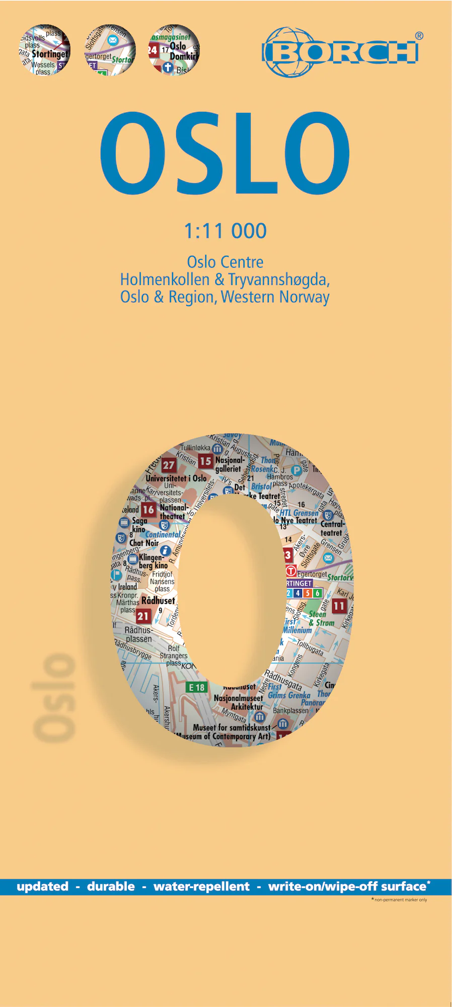
Oslo Borch Folded Laminated Map
Laminated Travel Map | Folded | Multi-Scale | Includes Public Transport & Regional Maps
Explore Norway’s capital with a durable, compact, and beautifully detailed city map.
🌆 Discover Oslo with Confidence and Clarity
The Borch Laminated City Map of Oslo is your ultimate navigation companion in one of Europe’s most livable capitals. Waterproof, tear-resistant, and thoughtfully designed, this soft-laminated folding map combines high-precision cartography with cultural insight. Perfect for urban explorers, cruise passengers, business travellers, or those discovering Oslo for the first time.
With five detailed map scales — from city centre to regional views — and an abundance of practical information, this is far more than a map. It’s a travel tool.
🌟 Map Coverage & Scales
| 🗺️ Map Section | 🔍 Scale |
|---|---|
| Oslo City Centre | 1:11,000 |
| Holmenkollen & Tryvannshøgda | 1:25,000 |
| Oslo & Surrounding Region | 1:200,000 |
| Western Norway (Vest-Norge) | 1:800,000 |
| Public Transport Map – Oslo | Schematic overview |
| Norway Administrative Divisions & Time Zones | National overview |
🧭 Key Features
| Feature | Benefit |
|---|---|
| 🧊 Laminated & Waterproof | Wipe-clean surface, ideal for outdoor use and variable Nordic weather |
| 🧳 Compact & Folded Format | Travel-ready size fits easily into daypacks or carry-ons |
| 📍 Top 30 Sights Highlighted | Must-see attractions clearly marked for easy discovery |
| 🗺️ Multiple Map Scales | City, suburb, regional and national perspectives all in one |
| 🚋 Public Transport Overview | Includes metro, tram, bus and ferry routes for seamless urban mobility |
| 🌦️ Climate Charts | Temperature, sunshine hours, humidity, and precipitation at a glance |
| 🎯 Travel Essentials | Hotels, museums, monuments, markets, parks, and cultural highlights |
| 📊 Useful Conversions | Quick-reference charts for weights, measures, and temperatures |
🏙️ About Oslo
-
Founded: c.1048 by King Harald III
-
Population: Approx. 1.4 million (metro area)
-
Geography: Located at the northern end of the Oslofjord
-
City Features:
-
40 islands and 343 lakes within city limits
-
Home to the Nobel Peace Center
-
Surrounded by forests, waterfalls, and nature trails
-
-
Climate:
-
Summer: Long daylight hours (up to 18 hours), mild to warm with occasional heatwaves
-
Winter: Short daylight (as little as 6 hours), with snowfall from January to March
-
-
Cultural Life:
-
Music, film, food and arts festivals year-round
-
Excellent public transport system and safe, walkable streets
-
World-class museums, galleries, and green spaces
-
📐 Product Specifications
| Specification | Detail |
|---|---|
| Map Title | Oslo Borch Folded Laminated Map |
| Publisher | Borch Maps (Germany) |
| Edition | 6th Edition (2016) |
| ISBN | 978-3-86609-310-2 |
| Scale | Multiple (1:11,000 to 1:800,000) |
| Map Size (Open) | 990 mm (W) x 494 mm (H) / 39 in x 19.5 in |
| Folded Size | 243 x 110 x 8 mm / 9.6 x 4.3 x 0.3 in |
| Weight | 81 g / 2.9 oz |
| Material | Soft-laminated, waterproof, tear-resistant |
🎯 Ideal For:
-
🧭 Independent travellers navigating Oslo and its surrounds
-
🛳️ Cruise passengers arriving into the Oslofjord
-
🎒 Backpackers and urban explorers
-
📚 Students and geography enthusiasts
-
🎁 Thoughtful gift for travellers and cartophiles
Explore Oslo with a map as well-made as the city itself.
Durable. Informative. Compact. Ready for your next Nordic adventure.
Original: $15.70
-65%$15.70
$5.49Product Information
Product Information
Shipping & Returns
Shipping & Returns
Description
Laminated Travel Map | Folded | Multi-Scale | Includes Public Transport & Regional Maps
Explore Norway’s capital with a durable, compact, and beautifully detailed city map.
🌆 Discover Oslo with Confidence and Clarity
The Borch Laminated City Map of Oslo is your ultimate navigation companion in one of Europe’s most livable capitals. Waterproof, tear-resistant, and thoughtfully designed, this soft-laminated folding map combines high-precision cartography with cultural insight. Perfect for urban explorers, cruise passengers, business travellers, or those discovering Oslo for the first time.
With five detailed map scales — from city centre to regional views — and an abundance of practical information, this is far more than a map. It’s a travel tool.
🌟 Map Coverage & Scales
| 🗺️ Map Section | 🔍 Scale |
|---|---|
| Oslo City Centre | 1:11,000 |
| Holmenkollen & Tryvannshøgda | 1:25,000 |
| Oslo & Surrounding Region | 1:200,000 |
| Western Norway (Vest-Norge) | 1:800,000 |
| Public Transport Map – Oslo | Schematic overview |
| Norway Administrative Divisions & Time Zones | National overview |
🧭 Key Features
| Feature | Benefit |
|---|---|
| 🧊 Laminated & Waterproof | Wipe-clean surface, ideal for outdoor use and variable Nordic weather |
| 🧳 Compact & Folded Format | Travel-ready size fits easily into daypacks or carry-ons |
| 📍 Top 30 Sights Highlighted | Must-see attractions clearly marked for easy discovery |
| 🗺️ Multiple Map Scales | City, suburb, regional and national perspectives all in one |
| 🚋 Public Transport Overview | Includes metro, tram, bus and ferry routes for seamless urban mobility |
| 🌦️ Climate Charts | Temperature, sunshine hours, humidity, and precipitation at a glance |
| 🎯 Travel Essentials | Hotels, museums, monuments, markets, parks, and cultural highlights |
| 📊 Useful Conversions | Quick-reference charts for weights, measures, and temperatures |
🏙️ About Oslo
-
Founded: c.1048 by King Harald III
-
Population: Approx. 1.4 million (metro area)
-
Geography: Located at the northern end of the Oslofjord
-
City Features:
-
40 islands and 343 lakes within city limits
-
Home to the Nobel Peace Center
-
Surrounded by forests, waterfalls, and nature trails
-
-
Climate:
-
Summer: Long daylight hours (up to 18 hours), mild to warm with occasional heatwaves
-
Winter: Short daylight (as little as 6 hours), with snowfall from January to March
-
-
Cultural Life:
-
Music, film, food and arts festivals year-round
-
Excellent public transport system and safe, walkable streets
-
World-class museums, galleries, and green spaces
-
📐 Product Specifications
| Specification | Detail |
|---|---|
| Map Title | Oslo Borch Folded Laminated Map |
| Publisher | Borch Maps (Germany) |
| Edition | 6th Edition (2016) |
| ISBN | 978-3-86609-310-2 |
| Scale | Multiple (1:11,000 to 1:800,000) |
| Map Size (Open) | 990 mm (W) x 494 mm (H) / 39 in x 19.5 in |
| Folded Size | 243 x 110 x 8 mm / 9.6 x 4.3 x 0.3 in |
| Weight | 81 g / 2.9 oz |
| Material | Soft-laminated, waterproof, tear-resistant |
🎯 Ideal For:
-
🧭 Independent travellers navigating Oslo and its surrounds
-
🛳️ Cruise passengers arriving into the Oslofjord
-
🎒 Backpackers and urban explorers
-
📚 Students and geography enthusiasts
-
🎁 Thoughtful gift for travellers and cartophiles
Explore Oslo with a map as well-made as the city itself.
Durable. Informative. Compact. Ready for your next Nordic adventure.


