Outback Queensland Hema Map 5th Edition
A detailed and indispensable guide for exploring the heart of Australia’s rugged interior — covering the vast and unforgettable landscapes of Queensland’s iconic outback
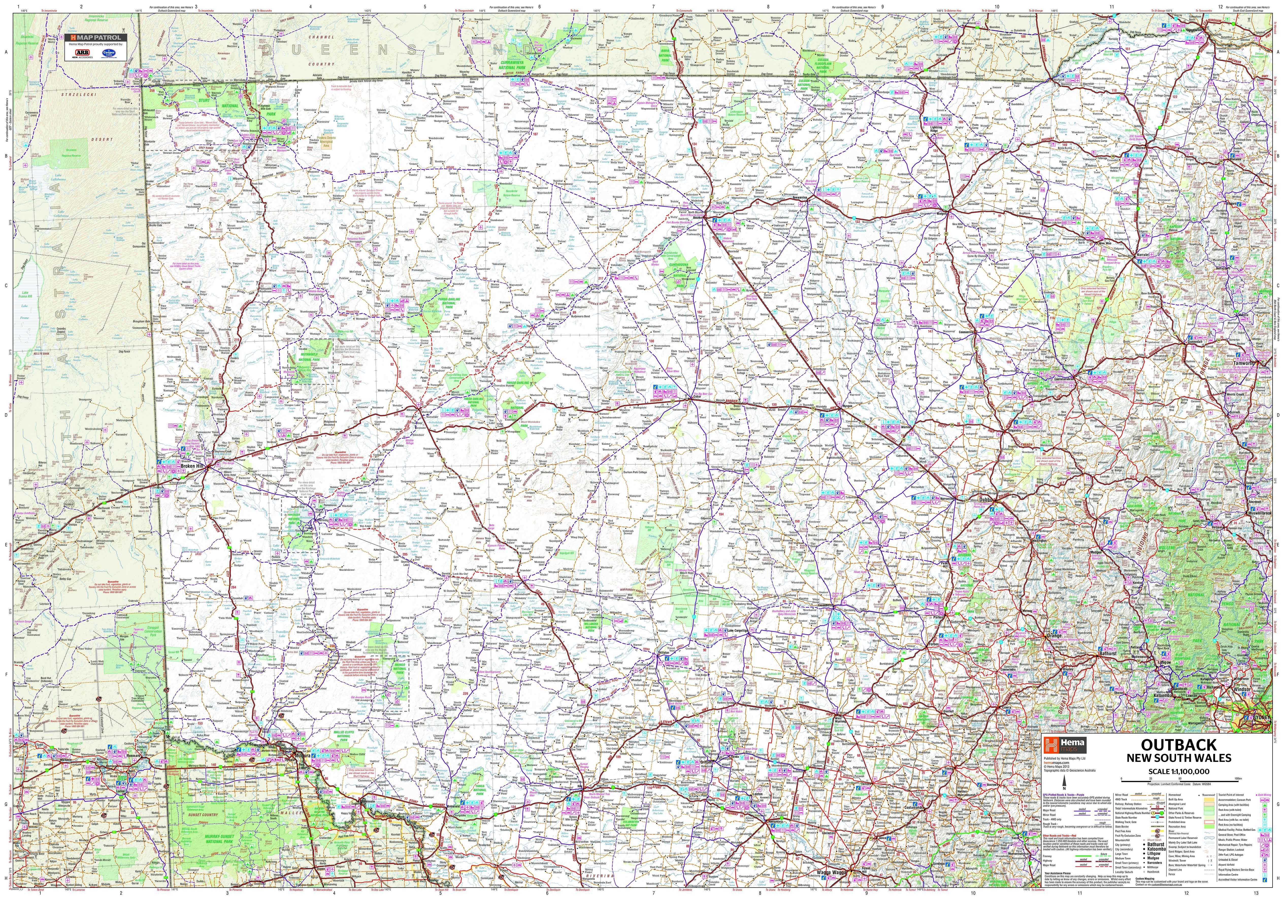
Published by Hema Maps, Australia’s most trusted name in off-road and remote navigation, the Outback Queensland Map – 5th Edition is the definitive map for discovering the remote heartlands of inland Queensland. Released in May 2023, this newly updated edition offers comprehensive coverage of outback highways, unsealed roads, national parks, heritage towns, and remote communities — helping you plan, navigate, and explore this extraordinary region with clarity and confidence.
Designed for 4WD adventurers, caravan travellers, road-trippers, and regional explorers, this map is more than just a tool — it’s your invitation to experience the cultural richness, geological wonders, and expansive freedom of Outback Queensland.
🗺️ Map Coverage and Detail
This fold-out touring map provides complete coverage of Outback Queensland, extending:
-
From Charters Towers in the north
-
To Toowoomba and the Darling Downs in the east
-
As far west as Birdsville, Boulia, Bedourie, and Camooweal
-
South to the Queensland–New South Wales border
Outback Queensland is divided into well-known travel regions such as:
-
Matilda Country
-
Channel Country
-
The Dinosaur Trail
-
The Overlanders Way
-
Warrego Way and Savannah Way
These regions are clearly defined and complemented by highlighted touring routes and recommended scenic drives, making the map perfect for planning both short getaways and extended road adventures.
🌄 Topographic and Tourist Mapping
-
Scale: 1:1,500,000 — striking the perfect balance between overview and detail
-
Relief shading and elevation tinting show terrain contours and help visualise the landscape
-
Key infrastructure and travel information marked, including:
-
Fuel stops and rest areas
-
Accommodation, caravan parks, and campgrounds
-
Points of interest and attractions
-
Unsealed roads, 4WD-only tracks, and road conditions
-
Public toilets, lookouts, boat ramps, and airstrips
-
This makes it ideal for planning logistics, locating services, and avoiding unpleasant surprises in remote areas.
🌿 National Parks Insets
Detailed inset maps of some of Outback Queensland’s most spectacular national parks are included, offering extra clarity for walkers, campers, and wildlife watchers:
-
Bladensburg National Park
-
Diamantina National Park
-
Idalia National Park
-
Currawinya National Park
-
Carnarvon Gorge
These insets include walking tracks, camping zones, road access, and key natural features such as gorges, rivers, and escarpments — essential for those wanting to go deeper into the outback experience.
📖 Visitor and Regional Information
The reverse side of the map includes:
-
Descriptions of Outback Queensland regions with historical context, Indigenous heritage, and cultural landmarks
-
Detailed notes on scenic drives, travel times, and seasonal road conditions
-
Tips on trip preparation, including water access, fuel range, and safety planning
-
A full town and locality index for fast reference
-
Essential contact numbers and websites for visitor centres, ranger stations, and emergency services
📐 Specifications
-
Edition: 5th
-
Publication Date: 30 May 2023
-
Folded Size: 140 mm x 250 mm x 3 mm
-
Flat Size: 700 mm x 1000 mm
-
Weight: Approx. 90 grams
-
Material: Printed on high-quality map stock, suitable for folding and regular field use
-
ISBN: 9781922668769
🎯 Who Is It For?
-
4WD and caravan travellers heading into remote country
-
Grey nomads and retirees mapping extended road journeys
-
Self-drive adventurers and camping families
-
Geography teachers and travel students exploring rural Australia
-
Tour guides and operators needing a reliable planning tool
-
Anyone travelling beyond the bitumen, where traditional GPS maps fall short
✅ Why Choose This Map?
-
Backed by Hema's Map Patrol — trusted for field-verified, real-world data collection
-
More detailed and reliable than standard digital maps, especially for unsealed or seasonal roads
-
Compact, portable, and durable — ideal for gloveboxes, panniers, or planning tables
-
A perfect complement to Hema’s digital apps or GPS navigation units
-
Ideal for tracking travel routes, journaling your journey, or marking completed tracks with map dots
Explore the real Australia — where red dirt roads meet open skies, where dinosaurs once walked, and where stories are written in the landscape.
The Outback Queensland Map – 5th Edition by Hema is more than just a chart — it’s your gateway to an unforgettable journey through one of the world’s most awe-inspiring regions.
Ready your rig. Unfold your map. Head for the horizon.
Original: $10.70
-65%$10.70
$3.74Product Information
Product Information
Shipping & Returns
Shipping & Returns
Description
A detailed and indispensable guide for exploring the heart of Australia’s rugged interior — covering the vast and unforgettable landscapes of Queensland’s iconic outback
Published by Hema Maps, Australia’s most trusted name in off-road and remote navigation, the Outback Queensland Map – 5th Edition is the definitive map for discovering the remote heartlands of inland Queensland. Released in May 2023, this newly updated edition offers comprehensive coverage of outback highways, unsealed roads, national parks, heritage towns, and remote communities — helping you plan, navigate, and explore this extraordinary region with clarity and confidence.
Designed for 4WD adventurers, caravan travellers, road-trippers, and regional explorers, this map is more than just a tool — it’s your invitation to experience the cultural richness, geological wonders, and expansive freedom of Outback Queensland.
🗺️ Map Coverage and Detail
This fold-out touring map provides complete coverage of Outback Queensland, extending:
-
From Charters Towers in the north
-
To Toowoomba and the Darling Downs in the east
-
As far west as Birdsville, Boulia, Bedourie, and Camooweal
-
South to the Queensland–New South Wales border
Outback Queensland is divided into well-known travel regions such as:
-
Matilda Country
-
Channel Country
-
The Dinosaur Trail
-
The Overlanders Way
-
Warrego Way and Savannah Way
These regions are clearly defined and complemented by highlighted touring routes and recommended scenic drives, making the map perfect for planning both short getaways and extended road adventures.
🌄 Topographic and Tourist Mapping
-
Scale: 1:1,500,000 — striking the perfect balance between overview and detail
-
Relief shading and elevation tinting show terrain contours and help visualise the landscape
-
Key infrastructure and travel information marked, including:
-
Fuel stops and rest areas
-
Accommodation, caravan parks, and campgrounds
-
Points of interest and attractions
-
Unsealed roads, 4WD-only tracks, and road conditions
-
Public toilets, lookouts, boat ramps, and airstrips
-
This makes it ideal for planning logistics, locating services, and avoiding unpleasant surprises in remote areas.
🌿 National Parks Insets
Detailed inset maps of some of Outback Queensland’s most spectacular national parks are included, offering extra clarity for walkers, campers, and wildlife watchers:
-
Bladensburg National Park
-
Diamantina National Park
-
Idalia National Park
-
Currawinya National Park
-
Carnarvon Gorge
These insets include walking tracks, camping zones, road access, and key natural features such as gorges, rivers, and escarpments — essential for those wanting to go deeper into the outback experience.
📖 Visitor and Regional Information
The reverse side of the map includes:
-
Descriptions of Outback Queensland regions with historical context, Indigenous heritage, and cultural landmarks
-
Detailed notes on scenic drives, travel times, and seasonal road conditions
-
Tips on trip preparation, including water access, fuel range, and safety planning
-
A full town and locality index for fast reference
-
Essential contact numbers and websites for visitor centres, ranger stations, and emergency services
📐 Specifications
-
Edition: 5th
-
Publication Date: 30 May 2023
-
Folded Size: 140 mm x 250 mm x 3 mm
-
Flat Size: 700 mm x 1000 mm
-
Weight: Approx. 90 grams
-
Material: Printed on high-quality map stock, suitable for folding and regular field use
-
ISBN: 9781922668769
🎯 Who Is It For?
-
4WD and caravan travellers heading into remote country
-
Grey nomads and retirees mapping extended road journeys
-
Self-drive adventurers and camping families
-
Geography teachers and travel students exploring rural Australia
-
Tour guides and operators needing a reliable planning tool
-
Anyone travelling beyond the bitumen, where traditional GPS maps fall short
✅ Why Choose This Map?
-
Backed by Hema's Map Patrol — trusted for field-verified, real-world data collection
-
More detailed and reliable than standard digital maps, especially for unsealed or seasonal roads
-
Compact, portable, and durable — ideal for gloveboxes, panniers, or planning tables
-
A perfect complement to Hema’s digital apps or GPS navigation units
-
Ideal for tracking travel routes, journaling your journey, or marking completed tracks with map dots
Explore the real Australia — where red dirt roads meet open skies, where dinosaurs once walked, and where stories are written in the landscape.
The Outback Queensland Map – 5th Edition by Hema is more than just a chart — it’s your gateway to an unforgettable journey through one of the world’s most awe-inspiring regions.
Ready your rig. Unfold your map. Head for the horizon.