Pacific Northwest Side 1 - Published 1986 by National Geographic
Making of America Series | Oregon Trail & Frontier History | Historical Regional Wall Map | 690 × 516 mm | Premium Finishes
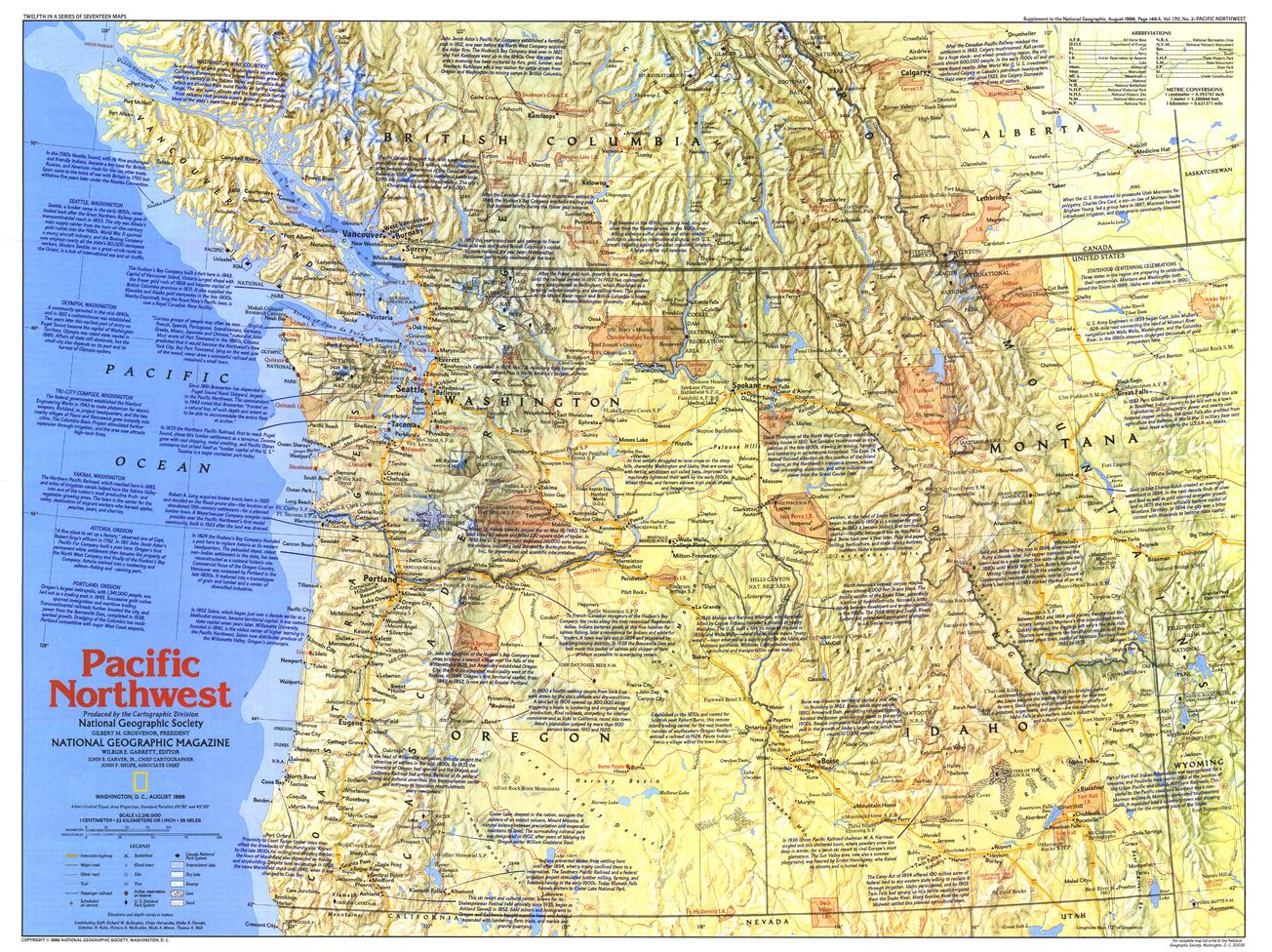
A region of movement, ambition, and striking natural beauty, Pacific Northwest — Side 1 brings the story of westward expansion into vivid focus. Published by National Geographic in August 1986 as part of the Making of America series, this map blends geography, history, and narrative detail across one of America’s most iconic landscapes.
Issued alongside the feature article “Life and Death on the Oregon Trail: The Itch to Move West,” it captures the routes, landmarks, and environments that defined the journey west.
Why This Map Stands Out
A story of westward expansion
Traces the routes and realities of migration into the Pacific Northwest.
Rich historical detail
Packed with notes and points of interest across the region.
Part of the Making of America series
Combines cartography with compelling storytelling.
A landscape of drama and scale
Highlights both natural beauty and human endeavour.
A refined wall map
Ideal for display, education, and collection.
🗺️ What the Map Shows
🛤️ Historic Routes & Migration
- The path of the Oregon Trail
- Key staging points, crossings, and landmarks along the journey west
- A geographic framework showing how terrain shaped migration routes
🌄 Regional Landscape
- The Pacific Northwest region, including forests, mountains, and river systems
- Major landforms that influenced settlement and travel
- A clear sense of the scale and challenge of the landscape
📍 Points of Interest
- Historic sites tied to frontier life and exploration
- Settlements and locations of significance along migration routes
- Notes providing context to the region’s development and history
🌲 A Region Defined by Movement
The Pacific Northwest tells a powerful story:
- A destination for those seeking new opportunities in the west
- A landscape of rivers, mountains, and dense forests
- A region shaped by perseverance, hardship, and ambition
- A place where geography dictated the pace and path of history
This map captures that journey—showing how people and landscape interacted to shape a region.
📐 Size & Format
690 mm (W) × 516 mm (H)
Landscape orientation
A versatile format ideal for:
- Classrooms and history education
- Home offices and study spaces
- Libraries and heritage displays
- Pairing with companion maps in the series
✨ Premium Finishes
| Format | Description |
|---|---|
| 📜 Heavyweight Paper (160 gsm matte) | Archival-quality, low-glare finish—ideal for framing. |
| 🧼 Laminated (True Encapsulation) | 2 × 80-micron gloss laminate, edge-sealed. Durable and wipe-clean. |
| 🪵 Laminated + Timber Hang Rails | Ready-to-hang with lacquered natural timber rails. Allow up to 10 working days. |
| 🖼️ Archival Canvas (395 gsm HP Professional Matte) | Museum-grade finish with pigment-based inks for depth and longevity. |
| 🪵 Canvas + Timber Hang Rails | Gallery-ready presentation. Allow up to 10 working days. |
📊 Specifications
| Feature | Detail |
|---|---|
| Title | Pacific Northwest — Side 1 |
| Publisher | National Geographic |
| Published | 1986 |
| Series | Making of America |
| Scale | 1:2,216,000 |
| Dimensions | 690 mm × 516 mm |
| Orientation | Landscape |
| Map Type | Historical / Regional |
| Coverage | Pacific Northwest, USA |
| Collections | USA, Historical, Regional |
| Materials | 160 gsm matte paper · 2 × 80-micron laminate · 395 gsm HP Professional Matte Canvas |
| Inks | Pigment-based, fade-resistant |
| Origin | Printed in Australia |
🎯 Ideal For
- Students and educators of American frontier history
- Collectors of National Geographic historical maps
- Enthusiasts of the Oregon Trail and westward migration
- Interiors seeking a heritage-inspired display piece
- Gift buyers looking for a story-rich map
🧭 The Pull of the West
The Pacific Northwest was a destination—and a challenge:
- Vast distances and rugged terrain tested every traveller
- Trails carved paths through mountains and rivers
- Settlements grew from determination and opportunity
- A region emerged shaped by both nature and human resolve
This map captures that spirit—offering a clear and compelling view of a landscape where the journey west became part of national identity.
🤝 Our Commitment
- Printed in Australia using archival-quality materials
- Faithfully reproduced to preserve clarity and historical detail
- Premium finishes designed for long-term display
- Each map is hand-checked and carefully packed
🚚 Delivery
- Rolled (Paper, Laminated, Canvas): Dispatch within 1–2 business days
- Hang-Railed Finishes: Made to order — allow up to 10 working days
Follow the trail west—
a map that brings the Pacific Northwest and its frontier story to life.
Product Information
Product Information
Shipping & Returns
Shipping & Returns
Description
Making of America Series | Oregon Trail & Frontier History | Historical Regional Wall Map | 690 × 516 mm | Premium Finishes
A region of movement, ambition, and striking natural beauty, Pacific Northwest — Side 1 brings the story of westward expansion into vivid focus. Published by National Geographic in August 1986 as part of the Making of America series, this map blends geography, history, and narrative detail across one of America’s most iconic landscapes.
Issued alongside the feature article “Life and Death on the Oregon Trail: The Itch to Move West,” it captures the routes, landmarks, and environments that defined the journey west.
Why This Map Stands Out
A story of westward expansion
Traces the routes and realities of migration into the Pacific Northwest.
Rich historical detail
Packed with notes and points of interest across the region.
Part of the Making of America series
Combines cartography with compelling storytelling.
A landscape of drama and scale
Highlights both natural beauty and human endeavour.
A refined wall map
Ideal for display, education, and collection.
🗺️ What the Map Shows
🛤️ Historic Routes & Migration
- The path of the Oregon Trail
- Key staging points, crossings, and landmarks along the journey west
- A geographic framework showing how terrain shaped migration routes
🌄 Regional Landscape
- The Pacific Northwest region, including forests, mountains, and river systems
- Major landforms that influenced settlement and travel
- A clear sense of the scale and challenge of the landscape
📍 Points of Interest
- Historic sites tied to frontier life and exploration
- Settlements and locations of significance along migration routes
- Notes providing context to the region’s development and history
🌲 A Region Defined by Movement
The Pacific Northwest tells a powerful story:
- A destination for those seeking new opportunities in the west
- A landscape of rivers, mountains, and dense forests
- A region shaped by perseverance, hardship, and ambition
- A place where geography dictated the pace and path of history
This map captures that journey—showing how people and landscape interacted to shape a region.
📐 Size & Format
690 mm (W) × 516 mm (H)
Landscape orientation
A versatile format ideal for:
- Classrooms and history education
- Home offices and study spaces
- Libraries and heritage displays
- Pairing with companion maps in the series
✨ Premium Finishes
| Format | Description |
|---|---|
| 📜 Heavyweight Paper (160 gsm matte) | Archival-quality, low-glare finish—ideal for framing. |
| 🧼 Laminated (True Encapsulation) | 2 × 80-micron gloss laminate, edge-sealed. Durable and wipe-clean. |
| 🪵 Laminated + Timber Hang Rails | Ready-to-hang with lacquered natural timber rails. Allow up to 10 working days. |
| 🖼️ Archival Canvas (395 gsm HP Professional Matte) | Museum-grade finish with pigment-based inks for depth and longevity. |
| 🪵 Canvas + Timber Hang Rails | Gallery-ready presentation. Allow up to 10 working days. |
📊 Specifications
| Feature | Detail |
|---|---|
| Title | Pacific Northwest — Side 1 |
| Publisher | National Geographic |
| Published | 1986 |
| Series | Making of America |
| Scale | 1:2,216,000 |
| Dimensions | 690 mm × 516 mm |
| Orientation | Landscape |
| Map Type | Historical / Regional |
| Coverage | Pacific Northwest, USA |
| Collections | USA, Historical, Regional |
| Materials | 160 gsm matte paper · 2 × 80-micron laminate · 395 gsm HP Professional Matte Canvas |
| Inks | Pigment-based, fade-resistant |
| Origin | Printed in Australia |
🎯 Ideal For
- Students and educators of American frontier history
- Collectors of National Geographic historical maps
- Enthusiasts of the Oregon Trail and westward migration
- Interiors seeking a heritage-inspired display piece
- Gift buyers looking for a story-rich map
🧭 The Pull of the West
The Pacific Northwest was a destination—and a challenge:
- Vast distances and rugged terrain tested every traveller
- Trails carved paths through mountains and rivers
- Settlements grew from determination and opportunity
- A region emerged shaped by both nature and human resolve
This map captures that spirit—offering a clear and compelling view of a landscape where the journey west became part of national identity.
🤝 Our Commitment
- Printed in Australia using archival-quality materials
- Faithfully reproduced to preserve clarity and historical detail
- Premium finishes designed for long-term display
- Each map is hand-checked and carefully packed
🚚 Delivery
- Rolled (Paper, Laminated, Canvas): Dispatch within 1–2 business days
- Hang-Railed Finishes: Made to order — allow up to 10 working days
Follow the trail west—
a map that brings the Pacific Northwest and its frontier story to life.


