Pacific Northwest Side 2 - Published 1986 by National Geographic
Making of America Series | From Tribal Lands to Modern Industry | Historical Thematic Wall Map | 690 × 516 mm | Premium Finishes
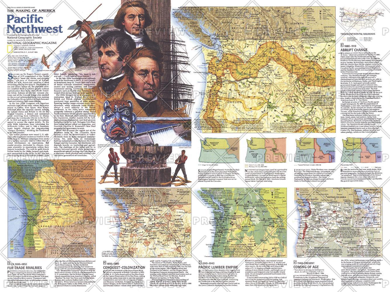
A deeper, more analytical companion to Side 1, Pacific Northwest — Side 2 charts the transformation of one of North America’s most spectacular regions. Published by National Geographic in August 1986 as part of the Making of America series, this map moves beyond geography to explore how the region evolved over time.
From Indigenous homelands and fur trading networks to hydroelectric power, timber, and tourism, it reveals the forces that shaped the modern Pacific Northwest.
Why This Map Stands Out
A story of transformation
Tracks the shift from tribal lands to a modern resource-based economy.
Layered historical insight
Uses multiple maps and notes to show change across time.
Companion to Side 1
Completes the narrative of the Pacific Northwest’s development.
Economic and environmental context
Explores industry, infrastructure, and conservation.
A thoughtful wall map
Ideal for study, discussion, and display.
🗺️ What the Map Shows
🌲 Early Landscapes & Cultures
- Indigenous territories and traditional land use
- Early settlement patterns and cultural geography
- The natural environment prior to large-scale development
🦫 Fur Trade & Exploration
- Locations of early trading posts
- Routes used by traders and explorers
- The role of the fur trade in opening the region
⚡ Industry & Infrastructure
- Expansion of the lumber industry across forested regions
- Development of hydroelectric dams and river systems
- Growth of transport and economic corridors
🏞️ Parks, Tourism & Modern Identity
- National parks and protected wilderness areas
- Emergence of tourism and recreation industries
- Resorts and destinations highlighting the region’s natural beauty
🌄 A Region Reimagined
The Pacific Northwest has undergone profound change:
- From Indigenous stewardship of land and resources
- To frontier trade and early settlement
- To industrial expansion driven by timber and water power
- To a modern region balancing conservation, recreation, and development
This map captures that evolution—showing how natural wealth and human ambition reshaped the landscape.
📐 Size & Format
690 mm (W) × 516 mm (H)
Landscape orientation
A versatile format ideal for:
- Classrooms and tertiary education
- Offices and planning environments
- Home libraries and study walls
- Pairing with Side 1 for a complete two-map set
✨ Premium Finishes
| Format | Description |
|---|---|
| 📜 Heavyweight Paper (160 gsm matte) | Archival-quality, low-glare finish—ideal for framing. |
| 🧼 Laminated (True Encapsulation) | 2 × 80-micron gloss laminate, edge-sealed. Durable and wipe-clean. |
| 🪵 Laminated + Timber Hang Rails | Ready-to-hang with lacquered natural timber rails. Allow up to 10 working days. |
| 🖼️ Archival Canvas (395 gsm HP Professional Matte) | Museum-grade finish with pigment-based, fade-resistant inks. |
| 🪵 Canvas + Timber Hang Rails | Gallery-ready presentation. Allow up to 10 working days. |
📊 Specifications
| Feature | Detail |
|---|---|
| Title | Pacific Northwest — Side 2 |
| Publisher | National Geographic |
| Published | 1986 |
| Series | Making of America |
| Dimensions | 690 mm × 516 mm |
| Orientation | Landscape |
| Map Type | Historical / Thematic |
| Coverage | Pacific Northwest, USA |
| Collections | North America, Historical |
| Materials | 160 gsm matte paper · 2 × 80-micron laminate · 395 gsm HP Professional Matte Canvas |
| Inks | Pigment-based, fade-resistant |
| Origin | Printed in Australia |
🎯 Ideal For
- Students and educators of American regional and economic history
- Collectors completing the Making of America series
- Those interested in environment, industry, and land use change
- Interiors seeking a thoughtful, narrative-driven display piece
- Gift buyers wanting a map with depth and meaning
🧭 More Than a Map—A Timeline
This map reveals:
- How landscapes are transformed over time
- How industries emerge from natural resources
- How infrastructure reshapes regions
- How modern identity evolves from historical foundations
It’s a map that answers not just where, but how and why the Pacific Northwest became what it is today.
🤝 Our Commitment
- Printed in Australia using archival-quality materials
- Faithfully reproduced to preserve clarity and historical detail
- Premium finishes designed for long-term display
- Each map is hand-checked and carefully packed
🚚 Delivery
- Rolled (Paper, Laminated, Canvas): Dispatch within 1–2 business days
- Hang-Railed Finishes: Made to order — allow up to 10 working days
Complete the story of the Pacific Northwest—
pair Side 2 with Side 1 to see the full journey from land to legacy.
Original: $50.05
-65%$50.05
$17.52Product Information
Product Information
Shipping & Returns
Shipping & Returns
Description
Making of America Series | From Tribal Lands to Modern Industry | Historical Thematic Wall Map | 690 × 516 mm | Premium Finishes
A deeper, more analytical companion to Side 1, Pacific Northwest — Side 2 charts the transformation of one of North America’s most spectacular regions. Published by National Geographic in August 1986 as part of the Making of America series, this map moves beyond geography to explore how the region evolved over time.
From Indigenous homelands and fur trading networks to hydroelectric power, timber, and tourism, it reveals the forces that shaped the modern Pacific Northwest.
Why This Map Stands Out
A story of transformation
Tracks the shift from tribal lands to a modern resource-based economy.
Layered historical insight
Uses multiple maps and notes to show change across time.
Companion to Side 1
Completes the narrative of the Pacific Northwest’s development.
Economic and environmental context
Explores industry, infrastructure, and conservation.
A thoughtful wall map
Ideal for study, discussion, and display.
🗺️ What the Map Shows
🌲 Early Landscapes & Cultures
- Indigenous territories and traditional land use
- Early settlement patterns and cultural geography
- The natural environment prior to large-scale development
🦫 Fur Trade & Exploration
- Locations of early trading posts
- Routes used by traders and explorers
- The role of the fur trade in opening the region
⚡ Industry & Infrastructure
- Expansion of the lumber industry across forested regions
- Development of hydroelectric dams and river systems
- Growth of transport and economic corridors
🏞️ Parks, Tourism & Modern Identity
- National parks and protected wilderness areas
- Emergence of tourism and recreation industries
- Resorts and destinations highlighting the region’s natural beauty
🌄 A Region Reimagined
The Pacific Northwest has undergone profound change:
- From Indigenous stewardship of land and resources
- To frontier trade and early settlement
- To industrial expansion driven by timber and water power
- To a modern region balancing conservation, recreation, and development
This map captures that evolution—showing how natural wealth and human ambition reshaped the landscape.
📐 Size & Format
690 mm (W) × 516 mm (H)
Landscape orientation
A versatile format ideal for:
- Classrooms and tertiary education
- Offices and planning environments
- Home libraries and study walls
- Pairing with Side 1 for a complete two-map set
✨ Premium Finishes
| Format | Description |
|---|---|
| 📜 Heavyweight Paper (160 gsm matte) | Archival-quality, low-glare finish—ideal for framing. |
| 🧼 Laminated (True Encapsulation) | 2 × 80-micron gloss laminate, edge-sealed. Durable and wipe-clean. |
| 🪵 Laminated + Timber Hang Rails | Ready-to-hang with lacquered natural timber rails. Allow up to 10 working days. |
| 🖼️ Archival Canvas (395 gsm HP Professional Matte) | Museum-grade finish with pigment-based, fade-resistant inks. |
| 🪵 Canvas + Timber Hang Rails | Gallery-ready presentation. Allow up to 10 working days. |
📊 Specifications
| Feature | Detail |
|---|---|
| Title | Pacific Northwest — Side 2 |
| Publisher | National Geographic |
| Published | 1986 |
| Series | Making of America |
| Dimensions | 690 mm × 516 mm |
| Orientation | Landscape |
| Map Type | Historical / Thematic |
| Coverage | Pacific Northwest, USA |
| Collections | North America, Historical |
| Materials | 160 gsm matte paper · 2 × 80-micron laminate · 395 gsm HP Professional Matte Canvas |
| Inks | Pigment-based, fade-resistant |
| Origin | Printed in Australia |
🎯 Ideal For
- Students and educators of American regional and economic history
- Collectors completing the Making of America series
- Those interested in environment, industry, and land use change
- Interiors seeking a thoughtful, narrative-driven display piece
- Gift buyers wanting a map with depth and meaning
🧭 More Than a Map—A Timeline
This map reveals:
- How landscapes are transformed over time
- How industries emerge from natural resources
- How infrastructure reshapes regions
- How modern identity evolves from historical foundations
It’s a map that answers not just where, but how and why the Pacific Northwest became what it is today.
🤝 Our Commitment
- Printed in Australia using archival-quality materials
- Faithfully reproduced to preserve clarity and historical detail
- Premium finishes designed for long-term display
- Each map is hand-checked and carefully packed
🚚 Delivery
- Rolled (Paper, Laminated, Canvas): Dispatch within 1–2 business days
- Hang-Railed Finishes: Made to order — allow up to 10 working days
Complete the story of the Pacific Northwest—
pair Side 2 with Side 1 to see the full journey from land to legacy.


