Pacific Ocean Floor - Atlas of the World, 10th Edition by National Geographic
Atlas of the World (10th Edition) | Pacific Basin Overview & Island Insets | Political Wall Map | 711 × 559 mm | Premium Finishes
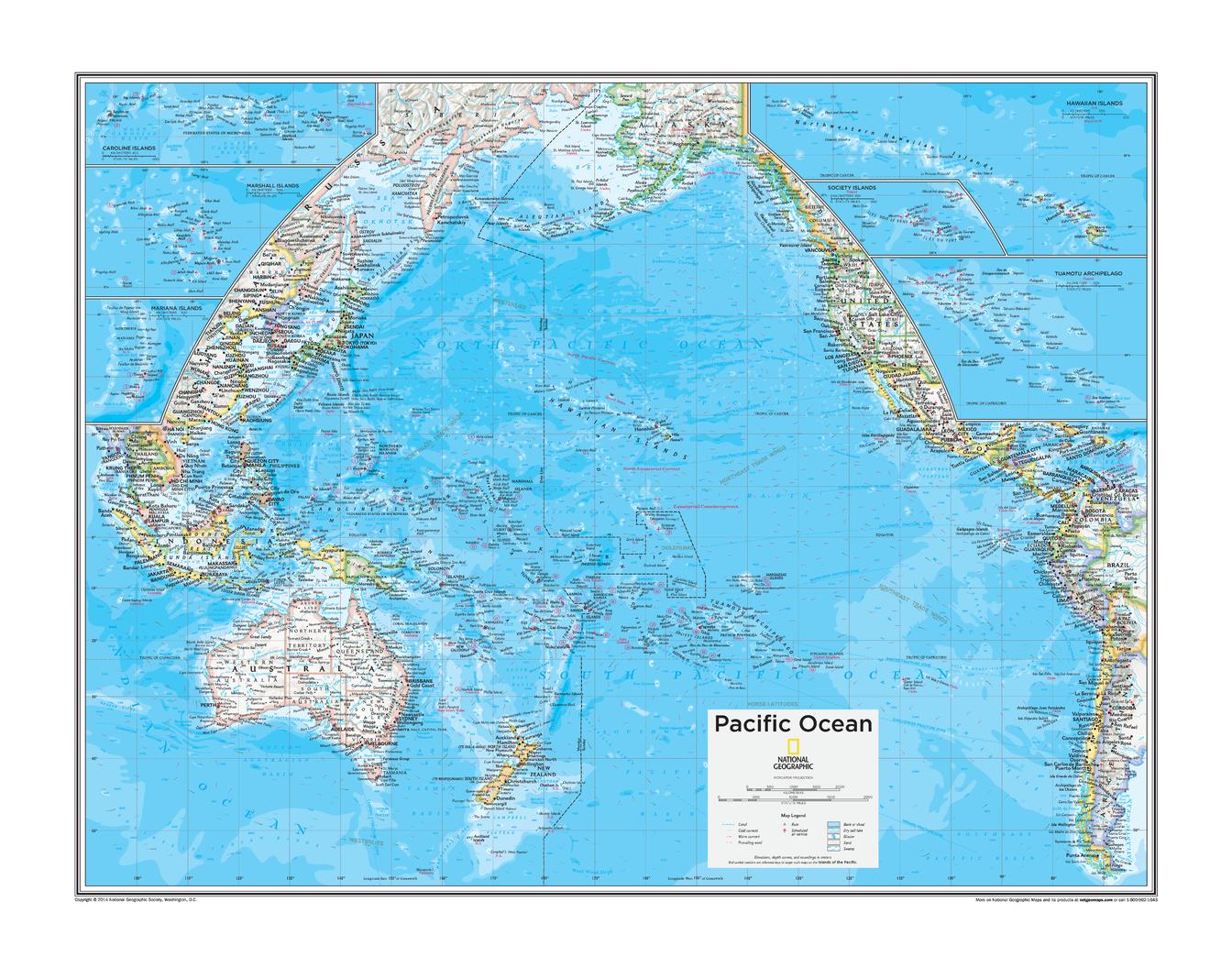
A sweeping, wall-ready view of the world’s largest ocean, Pacific Ocean presents the entire Pacific Basin with clarity, balance, and precision. Drawn from the Atlas of the World, 10th Edition by National Geographic, this map captures the geographic scale, island networks, and continental edges that define the Pacific.
From the Americas to Asia and Oceania, it’s a map that brings together distance, connection, and exploration in one coherent visual.
Why This Map Stands Out
A true Pacific-wide perspective
Shows the entire ocean basin in one continuous view.
Island detail where it matters
Inset maps provide clarity for key Pacific island groups.
Clean political presentation
Focuses on countries, boundaries, and major place names.
Atlas-quality design
Clear typography and balanced layout for easy readability.
A versatile wall map
Ideal for both reference and display.
🌊 What the Map Shows
🌏 The Pacific Basin
- Full coverage from:
- The western coasts of the Americas
- Across to Asia and Australia
- Major ocean regions and naming conventions
- A clear sense of the Pacific’s immense scale
🏝️ Detailed Island Insets
To enhance readability, the map includes dedicated insets of:
- Caroline Islands
- Hawaiian Islands
- Mariana Islands
- Marshall Islands
- Society Islands (French Polynesia)
- Tuamotu Archipelago (French Polynesia)
These insets allow smaller island groups to be viewed with greater clarity and detail than the main map scale permits.
🧭 A Map of Connection
The Pacific is not empty—it is a network:
- Island chains linking cultures and histories
- Ocean routes shaping exploration and trade
- Continents connected across vast distances
- A region where geography defines relationships
This map highlights those connections—showing the Pacific as a living, interconnected space.
📐 Size & Format
711 mm (W) × 559 mm (H)
Landscape orientation
A practical, display-friendly size ideal for:
- Classrooms and geography teaching
- Offices and planning environments
- Home studies and libraries
- Compact wall displays with strong visual impact
✨ Premium Finishes & Display Options
Every Pacific Ocean (2015) map is produced using archival-grade materials and precision colour management, ensuring crisp detail and long-term durability.
📜 Heavyweight Paper (160 gsm Matte)
Classic. Refined. Frame-ready.
- Premium matte-coated archival paper
- Smooth, low-glare surface for clarity
- Ideal for framing under glass
💡 Best for: traditional display and detailed study.
🧼 Laminated (True Encapsulation — 2 × 80 Micron Gloss)
Durable. Practical. Built to last.
- Fully sealed, edge-to-edge protection
- Resistant to wear, moisture, and handling
- Wipe-clean surface for annotation
💡 Best for: classrooms and interactive use.
🪵 Laminated + Timber Hang Rails
Ready to hang. Clean lines. Contemporary feel.
- Natural timber rails (top & bottom), lacquered finish
- Includes hanging cord
- Keeps map flat without framing
🔨 Please allow up to 10 working days.
💡 Best for: modern, ready-to-hang display.
🖼️ Archival Canvas (395 gsm HP Professional Matte)
Textured. Elegant. Gallery-quality.
- Museum-grade canvas with pigment inks
- Subtle texture enhances presentation
- Non-reflective finish
💡 Best for: feature walls and premium interiors.
🪵 Canvas + Timber Hang Rails
Gallery-ready. Warm. Architectural.
- Canvas paired with timber rails
- Clean, balanced presentation
🔨 Please allow up to 10 working days.
💡 Best for: statement display spaces.
📊 Specifications
| Feature | Detail |
|---|---|
| Title | Pacific Ocean |
| Publisher | National Geographic |
| Published | 2015 |
| Atlas | Atlas of the World, 10th Edition (Plate 109) |
| Dimensions | 711 mm × 559 mm |
| Orientation | Landscape |
| Map Type | Political |
| Coverage | Pacific Ocean Basin |
| Collections | Oceans, Political |
| Materials | 160 gsm matte paper · 2 × 80-micron laminate · 395 gsm HP Professional Matte Canvas |
| Inks | Pigment-based, fade-resistant |
| Origin | Printed in Australia |
🎯 Ideal For
- Students and educators of world geography
- Travellers and planners exploring the Pacific region
- Collectors of National Geographic atlas maps
- Interiors seeking a clean, expansive wall map
- Gift buyers looking for a timeless geographic reference
🌍 The World’s Largest Ocean, Made Legible
The Pacific can feel overwhelming in scale—
this map brings it into focus.
With clear structure, detailed insets, and balanced design, it offers a view of a region that covers more than a third of the Earth’s surface—yet remains beautifully readable on the wall.
🤝 Our Commitment
- Printed in Australia using archival-quality materials
- Faithfully reproduced for clarity and precision
- Premium finishes for long-term display
- Each map is hand-checked and carefully packed
🚚 Delivery
- Rolled (Paper, Laminated, Canvas): Dispatch within 1–2 business days
- Hang-Railed Finishes: Made to order — allow up to 10 working days
See the Pacific as a whole—
a map that connects continents, islands, and oceans in one sweeping view.
Original: $50.05
-65%$50.05
$17.52Product Information
Product Information
Shipping & Returns
Shipping & Returns
Description
Atlas of the World (10th Edition) | Pacific Basin Overview & Island Insets | Political Wall Map | 711 × 559 mm | Premium Finishes
A sweeping, wall-ready view of the world’s largest ocean, Pacific Ocean presents the entire Pacific Basin with clarity, balance, and precision. Drawn from the Atlas of the World, 10th Edition by National Geographic, this map captures the geographic scale, island networks, and continental edges that define the Pacific.
From the Americas to Asia and Oceania, it’s a map that brings together distance, connection, and exploration in one coherent visual.
Why This Map Stands Out
A true Pacific-wide perspective
Shows the entire ocean basin in one continuous view.
Island detail where it matters
Inset maps provide clarity for key Pacific island groups.
Clean political presentation
Focuses on countries, boundaries, and major place names.
Atlas-quality design
Clear typography and balanced layout for easy readability.
A versatile wall map
Ideal for both reference and display.
🌊 What the Map Shows
🌏 The Pacific Basin
- Full coverage from:
- The western coasts of the Americas
- Across to Asia and Australia
- Major ocean regions and naming conventions
- A clear sense of the Pacific’s immense scale
🏝️ Detailed Island Insets
To enhance readability, the map includes dedicated insets of:
- Caroline Islands
- Hawaiian Islands
- Mariana Islands
- Marshall Islands
- Society Islands (French Polynesia)
- Tuamotu Archipelago (French Polynesia)
These insets allow smaller island groups to be viewed with greater clarity and detail than the main map scale permits.
🧭 A Map of Connection
The Pacific is not empty—it is a network:
- Island chains linking cultures and histories
- Ocean routes shaping exploration and trade
- Continents connected across vast distances
- A region where geography defines relationships
This map highlights those connections—showing the Pacific as a living, interconnected space.
📐 Size & Format
711 mm (W) × 559 mm (H)
Landscape orientation
A practical, display-friendly size ideal for:
- Classrooms and geography teaching
- Offices and planning environments
- Home studies and libraries
- Compact wall displays with strong visual impact
✨ Premium Finishes & Display Options
Every Pacific Ocean (2015) map is produced using archival-grade materials and precision colour management, ensuring crisp detail and long-term durability.
📜 Heavyweight Paper (160 gsm Matte)
Classic. Refined. Frame-ready.
- Premium matte-coated archival paper
- Smooth, low-glare surface for clarity
- Ideal for framing under glass
💡 Best for: traditional display and detailed study.
🧼 Laminated (True Encapsulation — 2 × 80 Micron Gloss)
Durable. Practical. Built to last.
- Fully sealed, edge-to-edge protection
- Resistant to wear, moisture, and handling
- Wipe-clean surface for annotation
💡 Best for: classrooms and interactive use.
🪵 Laminated + Timber Hang Rails
Ready to hang. Clean lines. Contemporary feel.
- Natural timber rails (top & bottom), lacquered finish
- Includes hanging cord
- Keeps map flat without framing
🔨 Please allow up to 10 working days.
💡 Best for: modern, ready-to-hang display.
🖼️ Archival Canvas (395 gsm HP Professional Matte)
Textured. Elegant. Gallery-quality.
- Museum-grade canvas with pigment inks
- Subtle texture enhances presentation
- Non-reflective finish
💡 Best for: feature walls and premium interiors.
🪵 Canvas + Timber Hang Rails
Gallery-ready. Warm. Architectural.
- Canvas paired with timber rails
- Clean, balanced presentation
🔨 Please allow up to 10 working days.
💡 Best for: statement display spaces.
📊 Specifications
| Feature | Detail |
|---|---|
| Title | Pacific Ocean |
| Publisher | National Geographic |
| Published | 2015 |
| Atlas | Atlas of the World, 10th Edition (Plate 109) |
| Dimensions | 711 mm × 559 mm |
| Orientation | Landscape |
| Map Type | Political |
| Coverage | Pacific Ocean Basin |
| Collections | Oceans, Political |
| Materials | 160 gsm matte paper · 2 × 80-micron laminate · 395 gsm HP Professional Matte Canvas |
| Inks | Pigment-based, fade-resistant |
| Origin | Printed in Australia |
🎯 Ideal For
- Students and educators of world geography
- Travellers and planners exploring the Pacific region
- Collectors of National Geographic atlas maps
- Interiors seeking a clean, expansive wall map
- Gift buyers looking for a timeless geographic reference
🌍 The World’s Largest Ocean, Made Legible
The Pacific can feel overwhelming in scale—
this map brings it into focus.
With clear structure, detailed insets, and balanced design, it offers a view of a region that covers more than a third of the Earth’s surface—yet remains beautifully readable on the wall.
🤝 Our Commitment
- Printed in Australia using archival-quality materials
- Faithfully reproduced for clarity and precision
- Premium finishes for long-term display
- Each map is hand-checked and carefully packed
🚚 Delivery
- Rolled (Paper, Laminated, Canvas): Dispatch within 1–2 business days
- Hang-Railed Finishes: Made to order — allow up to 10 working days
See the Pacific as a whole—
a map that connects continents, islands, and oceans in one sweeping view.