Pacific Ocean Floor - Published 1969 by National Geographic
Classic Bathymetric Wall Map | Seafloor Topography & Mid-Century Cartography | 632 × 480 mm | Premium Finishes
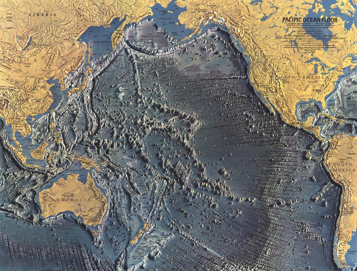
A landmark in ocean mapping, Pacific Ocean Floor reveals the vast, sculpted terrain hidden beneath the world’s largest ocean. Published by National Geographic in October 1969 as a companion to the Pacific Ocean map, this striking piece captures the excitement of a time when the deep sea was only just being understood.
With elegant shading and meticulous detail, it transforms the ocean floor into a readable landscape of ridges, trenches, and volcanic formations—a true fusion of science and art.
Why This Map Stands Out
A pioneering seafloor map
Represents one of the early visualisations of global ocean bathymetry.
Art meets science
Combines technical accuracy with beautifully balanced design.
Part of a classic ocean series
Complements companion maps of the Indian (1967), Atlantic (1968), and Arctic (1971) Oceans.
Rich terrain detail
Highlights the complexity of the Pacific’s underwater landscape.
A timeless collector’s piece
Captures a key moment in oceanographic discovery.
🌊 What the Map Shows
⛰️ Submarine Landscapes
- Continental margins and continental slopes descending into deep ocean basins
- Vast abyssal plains and mid-ocean features
- Thousands of seamounts rising from the ocean floor
🌐 Geological Structure
- Fracture zones and tectonic boundaries
- Ocean ridges and volcanic formations
- The underlying structure of the Pacific Basin
🧭 A New Way of Seeing the Ocean
- The ocean floor presented as a continuous, readable terrain
- Depth and form conveyed through subtle shading and colour
- A framework linking geology, plate movement, and ocean structure
🌌 Revealing the Hidden Earth
In the late 1960s, mapping the ocean floor was revolutionary:
- Sonar and new technologies unveiled unseen landscapes
- Scientists began to understand plate tectonics and seafloor spreading
- The oceans were revealed as dynamic, ever-changing systems
This map captures that breakthrough—offering a window into a world once hidden from view.
📐 Size & Format
632 mm (W) × 480 mm (H)
Landscape orientation
A compact and elegant format ideal for:
- Framed collections
- Offices and study spaces
- Libraries and educational displays
- Interiors with a scientific or vintage aesthetic
✨ Premium Finishes & Display Options
Every Pacific Ocean Floor (1969) map is produced using archival-grade materials and precision colour management, ensuring the intricate bathymetric detail and tonal shading remain crisp, legible, and visually striking for years to come.
📜 Heavyweight Paper (160 gsm Matte)
Classic. Refined. Frame-ready.
- Premium matte-coated archival paper
- Smooth, non-reflective finish for fine detail
- Ideal for framing under glass
💡 Best for: collectors and traditional display settings.
🧼 Laminated (True Encapsulation — 2 × 80 Micron Gloss)
Durable. Practical. Built to last.
- Fully sealed, edge-to-edge protection
- Tear, moisture, and stain resistant
- Wipe-clean surface for markers and map dots
💡 Best for: classrooms, offices, and active use.
🪵 Laminated + Timber Hang Rails
Ready to hang. Clean lines.
- Natural timber rails (top and bottom), lacquered finish
- Includes hanging cord for instant display
- Keeps map flat without framing
🔨 Allow up to 10 working days for mounting.
💡 Best for: modern, frame-free presentation.
🖼️ Archival Canvas (395 gsm HP Professional Matte)
Textured. Elegant. Gallery-quality.
- Museum-grade canvas with pigment-based inks
- Non-reflective surface with subtle texture
- Rich depth and colour longevity
💡 Best for: feature walls and premium interiors.
🪵 Canvas + Timber Hang Rails
Gallery-ready. Warm. Architectural.
- Canvas paired with natural timber rails
- Clean, balanced, ready-to-hang finish
🔨 Allow up to 10 working days for mounting.
💡 Best for: high-end statement display.
📊 Specifications
| Feature | Detail |
|---|---|
| Title | Pacific Ocean Floor |
| Publisher | National Geographic |
| Published | 1969 |
| Scale | 1:36,432,000 |
| Dimensions | 632 mm × 480 mm |
| Orientation | Landscape |
| Map Type | Physical / Thematic |
| Coverage | Pacific Ocean |
| Collections | Oceans, Thematic, Physical |
| Materials | 160 gsm matte paper · 2 × 80-micron laminate · 395 gsm HP Professional Matte Canvas |
| Inks | Pigment-based, fade-resistant |
| Origin | Printed in Australia |
🎯 Ideal For
- Collectors of classic National Geographic ocean maps
- Enthusiasts of marine geology and oceanography
- Students exploring plate tectonics and seafloor structure
- Interiors seeking a scientific, conversation-starting display
🌍 The Ocean Revealed
Beneath the Pacific lies:
- Mountain ranges larger than those on land
- Fracture lines marking the movement of continents
- Seamounts rising like submerged volcanoes
This map brings that hidden world into view—offering a compelling look at the Earth beneath the ocean’s surface.
🤝 Our Commitment
- Printed in Australia using archival-quality materials
- Faithfully reproduced to preserve depth, clarity, and tone
- Each map is hand-checked and carefully packed
🚚 Delivery
- Rolled (Paper, Laminated, Canvas): Dispatch within 1–2 business days
- Hang-Railed Finishes: Made to order — allow up to 10 working days
Discover the landscape beneath the waves—
a map that transforms the Pacific Ocean into a world you can finally see.
Original: $50.05
-65%$50.05
$17.52Product Information
Product Information
Shipping & Returns
Shipping & Returns
Description
Classic Bathymetric Wall Map | Seafloor Topography & Mid-Century Cartography | 632 × 480 mm | Premium Finishes
A landmark in ocean mapping, Pacific Ocean Floor reveals the vast, sculpted terrain hidden beneath the world’s largest ocean. Published by National Geographic in October 1969 as a companion to the Pacific Ocean map, this striking piece captures the excitement of a time when the deep sea was only just being understood.
With elegant shading and meticulous detail, it transforms the ocean floor into a readable landscape of ridges, trenches, and volcanic formations—a true fusion of science and art.
Why This Map Stands Out
A pioneering seafloor map
Represents one of the early visualisations of global ocean bathymetry.
Art meets science
Combines technical accuracy with beautifully balanced design.
Part of a classic ocean series
Complements companion maps of the Indian (1967), Atlantic (1968), and Arctic (1971) Oceans.
Rich terrain detail
Highlights the complexity of the Pacific’s underwater landscape.
A timeless collector’s piece
Captures a key moment in oceanographic discovery.
🌊 What the Map Shows
⛰️ Submarine Landscapes
- Continental margins and continental slopes descending into deep ocean basins
- Vast abyssal plains and mid-ocean features
- Thousands of seamounts rising from the ocean floor
🌐 Geological Structure
- Fracture zones and tectonic boundaries
- Ocean ridges and volcanic formations
- The underlying structure of the Pacific Basin
🧭 A New Way of Seeing the Ocean
- The ocean floor presented as a continuous, readable terrain
- Depth and form conveyed through subtle shading and colour
- A framework linking geology, plate movement, and ocean structure
🌌 Revealing the Hidden Earth
In the late 1960s, mapping the ocean floor was revolutionary:
- Sonar and new technologies unveiled unseen landscapes
- Scientists began to understand plate tectonics and seafloor spreading
- The oceans were revealed as dynamic, ever-changing systems
This map captures that breakthrough—offering a window into a world once hidden from view.
📐 Size & Format
632 mm (W) × 480 mm (H)
Landscape orientation
A compact and elegant format ideal for:
- Framed collections
- Offices and study spaces
- Libraries and educational displays
- Interiors with a scientific or vintage aesthetic
✨ Premium Finishes & Display Options
Every Pacific Ocean Floor (1969) map is produced using archival-grade materials and precision colour management, ensuring the intricate bathymetric detail and tonal shading remain crisp, legible, and visually striking for years to come.
📜 Heavyweight Paper (160 gsm Matte)
Classic. Refined. Frame-ready.
- Premium matte-coated archival paper
- Smooth, non-reflective finish for fine detail
- Ideal for framing under glass
💡 Best for: collectors and traditional display settings.
🧼 Laminated (True Encapsulation — 2 × 80 Micron Gloss)
Durable. Practical. Built to last.
- Fully sealed, edge-to-edge protection
- Tear, moisture, and stain resistant
- Wipe-clean surface for markers and map dots
💡 Best for: classrooms, offices, and active use.
🪵 Laminated + Timber Hang Rails
Ready to hang. Clean lines.
- Natural timber rails (top and bottom), lacquered finish
- Includes hanging cord for instant display
- Keeps map flat without framing
🔨 Allow up to 10 working days for mounting.
💡 Best for: modern, frame-free presentation.
🖼️ Archival Canvas (395 gsm HP Professional Matte)
Textured. Elegant. Gallery-quality.
- Museum-grade canvas with pigment-based inks
- Non-reflective surface with subtle texture
- Rich depth and colour longevity
💡 Best for: feature walls and premium interiors.
🪵 Canvas + Timber Hang Rails
Gallery-ready. Warm. Architectural.
- Canvas paired with natural timber rails
- Clean, balanced, ready-to-hang finish
🔨 Allow up to 10 working days for mounting.
💡 Best for: high-end statement display.
📊 Specifications
| Feature | Detail |
|---|---|
| Title | Pacific Ocean Floor |
| Publisher | National Geographic |
| Published | 1969 |
| Scale | 1:36,432,000 |
| Dimensions | 632 mm × 480 mm |
| Orientation | Landscape |
| Map Type | Physical / Thematic |
| Coverage | Pacific Ocean |
| Collections | Oceans, Thematic, Physical |
| Materials | 160 gsm matte paper · 2 × 80-micron laminate · 395 gsm HP Professional Matte Canvas |
| Inks | Pigment-based, fade-resistant |
| Origin | Printed in Australia |
🎯 Ideal For
- Collectors of classic National Geographic ocean maps
- Enthusiasts of marine geology and oceanography
- Students exploring plate tectonics and seafloor structure
- Interiors seeking a scientific, conversation-starting display
🌍 The Ocean Revealed
Beneath the Pacific lies:
- Mountain ranges larger than those on land
- Fracture lines marking the movement of continents
- Seamounts rising like submerged volcanoes
This map brings that hidden world into view—offering a compelling look at the Earth beneath the ocean’s surface.
🤝 Our Commitment
- Printed in Australia using archival-quality materials
- Faithfully reproduced to preserve depth, clarity, and tone
- Each map is hand-checked and carefully packed
🚚 Delivery
- Rolled (Paper, Laminated, Canvas): Dispatch within 1–2 business days
- Hang-Railed Finishes: Made to order — allow up to 10 working days
Discover the landscape beneath the waves—
a map that transforms the Pacific Ocean into a world you can finally see.


