Pacific Ocean - Published 1992 by National Geographic
Deep-Sea Topography & Hydrothermal Worlds | Physical Ocean Wall Map | 796 × 517 mm | Premium Finishes
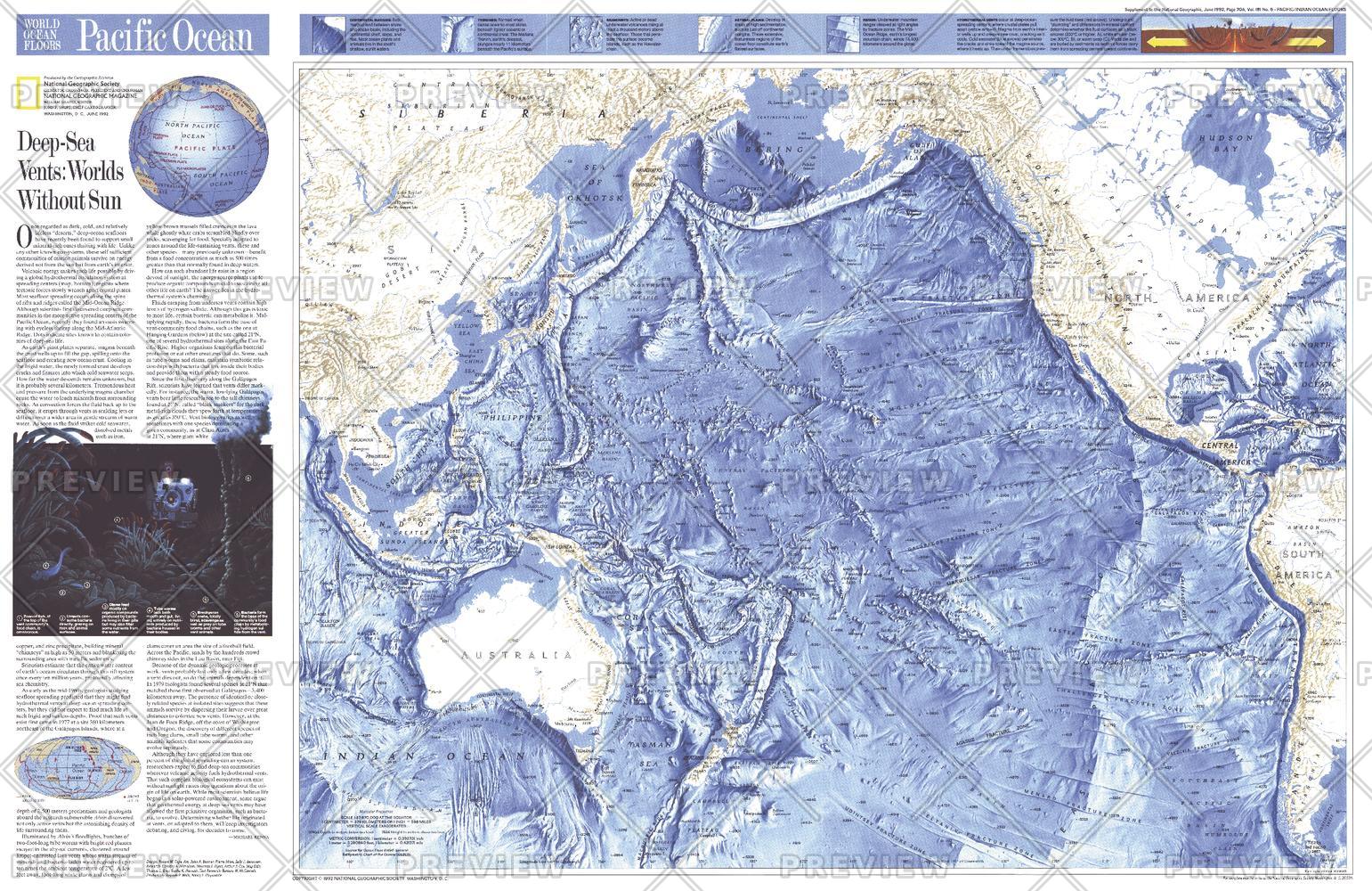
A captivating descent into the hidden landscapes beneath the Pacific, Pacific Ocean Floor reveals a world of depth, pressure, and life beyond sunlight. Published by National Geographic in June 1992, this striking map accompanied the feature article “Deep-Sea Vents: Worlds Without Sun,” bringing to life the extraordinary ecosystems found in Earth’s most remote environments.
From vast trenches to volcanic ridges and hydrothermal vents, it presents the Pacific not as a surface—but as a complex, living terrain below the waves.
Why This Map Stands Out
A rare look beneath the ocean surface
Maps the Pacific seafloor in remarkable detail.
Scientific and visually striking
Combines bathymetry with narrative insight into deep-sea ecosystems.
Linked to groundbreaking research
Highlights discoveries around hydrothermal vent communities.
Part of a broader ocean series
Pairs with the Indian Ocean floor map from the same issue.
A unique collector’s piece
Blends science, exploration, and elegant cartography.
🌊 What the Map Shows
⛰️ Seafloor Topography
- Major underwater features including:
- Deep ocean trenches and troughs
- Mid-ocean ridges and fracture zones
- Extensive seamount chains and submarine plateaus
- A clear visualisation of depth through detailed shading and contouring
🌋 Dynamic Geological Systems
- Plate boundaries and tectonic structures shaping the Pacific Basin
- Volcanic activity beneath the ocean surface
- The formation of ridges, faults, and oceanic crust
🐙 Life in Extreme Environments
- Locations associated with hydrothermal vents
- Insights into ecosystems thriving without sunlight
- A framework connecting geology with deep-sea biology
🌌 Worlds Without Sun
The deep Pacific is one of Earth’s most extraordinary environments:
- Total darkness beyond the reach of sunlight
- Extreme pressure and temperature variations
- Life forms sustained by chemical energy rather than photosynthesis
- Ecosystems unlike anything found on land
This map captures that hidden world—offering a powerful visual of a realm where science continues to uncover new frontiers.
📐 Size & Format
796 mm (W) × 517 mm (H)
Landscape orientation
A clean, display-ready format ideal for:
- Classrooms and science education
- Universities and research spaces
- Offices and environmental organisations
- Interiors seeking a unique scientific focal point
✨ Premium Finishes
| Format | Description |
|---|---|
| 📜 Heavyweight Paper (160 gsm matte) | Archival-quality, low-glare finish—ideal for framing. |
| 🧼 Laminated (True Encapsulation) | 2 × 80-micron gloss laminate, edge-sealed. Durable and wipe-clean. |
| 🪵 Laminated + Timber Hang Rails | Ready-to-hang with lacquered natural timber rails. Allow up to 10 working days. |
| 🖼️ Archival Canvas (395 gsm HP Professional Matte) | Museum-grade finish with pigment-based, fade-resistant inks. |
| 🪵 Canvas + Timber Hang Rails | Gallery-ready presentation. Allow up to 10 working days. |
📊 Specifications
| Feature | Detail |
|---|---|
| Title | Pacific Ocean Floor |
| Publisher | National Geographic |
| Published | 1992 |
| Dimensions | 796 mm × 517 mm |
| Orientation | Landscape |
| Map Type | Physical / Bathymetric |
| Coverage | Pacific Ocean |
| Collections | Oceans, Historical |
| Materials | 160 gsm matte paper · 2 × 80-micron laminate · 395 gsm HP Professional Matte Canvas |
| Inks | Pigment-based, fade-resistant |
| Origin | Printed in Australia |
🎯 Ideal For
- Students and educators of marine science and geology
- Researchers and enthusiasts of deep-sea exploration
- Collectors of National Geographic scientific maps
- Interiors seeking a unique, conversation-starting display piece
- Gift buyers looking for a map with depth—literally and intellectually
🌍 The Hidden Landscape of Earth
Beneath the Pacific lies:
- Mountain ranges larger than those on land
- Trenches deeper than Everest is tall
- Ecosystems thriving in complete darkness
- Geological processes shaping the planet in real time
This map brings that unseen world into view—offering a clear and compelling look at the Earth beneath the ocean’s surface.
🤝 Our Commitment
- Printed in Australia using archival-quality materials
- Faithfully reproduced to preserve depth, colour, and detail
- Premium finishes designed for long-term display
- Each map is hand-checked and carefully packed
🚚 Delivery
- Rolled (Paper, Laminated, Canvas): Dispatch within 1–2 business days
- Hang-Railed Finishes: Made to order — allow up to 10 working days
Dive beneath the surface—
a map that reveals the Pacific as a world of depth, mystery, and discovery.
Original: $50.05
-65%$50.05
$17.52Product Information
Product Information
Shipping & Returns
Shipping & Returns
Description
Deep-Sea Topography & Hydrothermal Worlds | Physical Ocean Wall Map | 796 × 517 mm | Premium Finishes
A captivating descent into the hidden landscapes beneath the Pacific, Pacific Ocean Floor reveals a world of depth, pressure, and life beyond sunlight. Published by National Geographic in June 1992, this striking map accompanied the feature article “Deep-Sea Vents: Worlds Without Sun,” bringing to life the extraordinary ecosystems found in Earth’s most remote environments.
From vast trenches to volcanic ridges and hydrothermal vents, it presents the Pacific not as a surface—but as a complex, living terrain below the waves.
Why This Map Stands Out
A rare look beneath the ocean surface
Maps the Pacific seafloor in remarkable detail.
Scientific and visually striking
Combines bathymetry with narrative insight into deep-sea ecosystems.
Linked to groundbreaking research
Highlights discoveries around hydrothermal vent communities.
Part of a broader ocean series
Pairs with the Indian Ocean floor map from the same issue.
A unique collector’s piece
Blends science, exploration, and elegant cartography.
🌊 What the Map Shows
⛰️ Seafloor Topography
- Major underwater features including:
- Deep ocean trenches and troughs
- Mid-ocean ridges and fracture zones
- Extensive seamount chains and submarine plateaus
- A clear visualisation of depth through detailed shading and contouring
🌋 Dynamic Geological Systems
- Plate boundaries and tectonic structures shaping the Pacific Basin
- Volcanic activity beneath the ocean surface
- The formation of ridges, faults, and oceanic crust
🐙 Life in Extreme Environments
- Locations associated with hydrothermal vents
- Insights into ecosystems thriving without sunlight
- A framework connecting geology with deep-sea biology
🌌 Worlds Without Sun
The deep Pacific is one of Earth’s most extraordinary environments:
- Total darkness beyond the reach of sunlight
- Extreme pressure and temperature variations
- Life forms sustained by chemical energy rather than photosynthesis
- Ecosystems unlike anything found on land
This map captures that hidden world—offering a powerful visual of a realm where science continues to uncover new frontiers.
📐 Size & Format
796 mm (W) × 517 mm (H)
Landscape orientation
A clean, display-ready format ideal for:
- Classrooms and science education
- Universities and research spaces
- Offices and environmental organisations
- Interiors seeking a unique scientific focal point
✨ Premium Finishes
| Format | Description |
|---|---|
| 📜 Heavyweight Paper (160 gsm matte) | Archival-quality, low-glare finish—ideal for framing. |
| 🧼 Laminated (True Encapsulation) | 2 × 80-micron gloss laminate, edge-sealed. Durable and wipe-clean. |
| 🪵 Laminated + Timber Hang Rails | Ready-to-hang with lacquered natural timber rails. Allow up to 10 working days. |
| 🖼️ Archival Canvas (395 gsm HP Professional Matte) | Museum-grade finish with pigment-based, fade-resistant inks. |
| 🪵 Canvas + Timber Hang Rails | Gallery-ready presentation. Allow up to 10 working days. |
📊 Specifications
| Feature | Detail |
|---|---|
| Title | Pacific Ocean Floor |
| Publisher | National Geographic |
| Published | 1992 |
| Dimensions | 796 mm × 517 mm |
| Orientation | Landscape |
| Map Type | Physical / Bathymetric |
| Coverage | Pacific Ocean |
| Collections | Oceans, Historical |
| Materials | 160 gsm matte paper · 2 × 80-micron laminate · 395 gsm HP Professional Matte Canvas |
| Inks | Pigment-based, fade-resistant |
| Origin | Printed in Australia |
🎯 Ideal For
- Students and educators of marine science and geology
- Researchers and enthusiasts of deep-sea exploration
- Collectors of National Geographic scientific maps
- Interiors seeking a unique, conversation-starting display piece
- Gift buyers looking for a map with depth—literally and intellectually
🌍 The Hidden Landscape of Earth
Beneath the Pacific lies:
- Mountain ranges larger than those on land
- Trenches deeper than Everest is tall
- Ecosystems thriving in complete darkness
- Geological processes shaping the planet in real time
This map brings that unseen world into view—offering a clear and compelling look at the Earth beneath the ocean’s surface.
🤝 Our Commitment
- Printed in Australia using archival-quality materials
- Faithfully reproduced to preserve depth, colour, and detail
- Premium finishes designed for long-term display
- Each map is hand-checked and carefully packed
🚚 Delivery
- Rolled (Paper, Laminated, Canvas): Dispatch within 1–2 business days
- Hang-Railed Finishes: Made to order — allow up to 10 working days
Dive beneath the surface—
a map that reveals the Pacific as a world of depth, mystery, and discovery.


