Pakistan Wall Map 914 x 610mm
Physical & Political Detail | Indus Basin to Arabian Sea | Premium Finishes
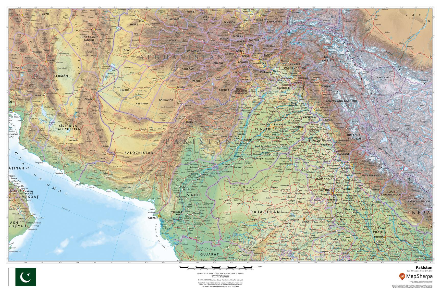
Explore Pakistan in striking wall-ready clarity. This large-format map blends clean political boundaries with beautiful physical cartography—from the Karakoram and western Himalaya to the Balochistan Plateau, Thar Desert, and the Indus River as it flows to the Arabian Sea. Subtle relief shading and elevation colour-bands make landforms instantly legible, while cities, roads, and borders support learning, planning, and elegant display.
🗺️ Map Features
-
Physical + Political Coverage – National borders, provinces (where shown), key cities/towns, highways and rail, layered over refined terrain.
-
Relief Shading & Elevation Tints – Hypsometric colours and hillshading highlight high mountain massifs, plateaus, and coastal plains at a glance.
-
Hydrology & Coastline – Clear depiction of the Indus River system, major tributaries, reservoirs, and the Arabian Sea shoreline.
-
Regional Orientation – Neighbouring context for India, Afghanistan, Iran, China for complete geographic continuity.
-
Wall-Optimised Cartography – Balanced label hierarchy and crisp symbology ensure clarity without clutter at typical viewing distances.
✨ Available Finishes
| Format | Description |
|---|---|
| 📜 Paper (160 gsm) | Heavyweight matte-coated paper—perfect for framing under glass. |
| 🧼 Laminated (Encapsulated) | Fully sealed in 80-micron gloss laminate—durable, wipe-clean, and great for notes. |
| 🪵 Laminated with Wooden Hang Rails | Laminated map mounted with lacquered natural timber rails (top & bottom) and a hanging cord—ready to display. |
| 🖼️ Canvas (395 gsm) | HP Professional Matte Canvas printed with archival pigment-based inks—rich texture, fade-resistant, gallery grade. |
| 🪵 Canvas with Wooden Hang Rails | Canvas finished with lacquered timber rails and a hanging cord—timeless, frame-free presentation. |
🔨 Hang-railed maps are made to order—please allow up to 10 working days for professional mounting.
📐 Specifications
| Feature | Detail |
|---|---|
| Title | Pakistan Wall Map |
| Map Type | Physical / Political |
| Scale | 1:3,000,000 (≈ 1 cm = 30 km) |
| Dimensions | 914 mm (W) × 610 mm (H) |
| Orientation | Landscape |
| Materials | Paper, Laminated, Canvas, With or Without Timber Rails |
| Printing | Archival pigment-based inks, fade-resistant |
💡 Why You’ll Love It
-
Landscape clarity—mountain ranges, deserts, and river plains rendered in elegant relief.
-
Clear political framing to support lessons, planning, and presentations.
-
Five premium finishes to suit classrooms, offices, studios, and homes.
-
Built to last—laminated/canvas options handle frequent use and stay colour-true.
🚚 Delivery
-
Paper, Laminated & Canvas (rolled): Usually ships within 1–2 business days.
-
Hang-railed versions: Made to order; allow up to 10 working days.
-
Packaging: Securely protected to arrive in pristine condition.
Bring Pakistan’s mountains, deserts, and the Indus heartland into focus. Choose your finish, hang with ease, and enjoy a map that’s both beautiful and deeply useful.
Original: $64.36
-65%$64.36
$22.53Product Information
Product Information
Shipping & Returns
Shipping & Returns
Description
Physical & Political Detail | Indus Basin to Arabian Sea | Premium Finishes
Explore Pakistan in striking wall-ready clarity. This large-format map blends clean political boundaries with beautiful physical cartography—from the Karakoram and western Himalaya to the Balochistan Plateau, Thar Desert, and the Indus River as it flows to the Arabian Sea. Subtle relief shading and elevation colour-bands make landforms instantly legible, while cities, roads, and borders support learning, planning, and elegant display.
🗺️ Map Features
-
Physical + Political Coverage – National borders, provinces (where shown), key cities/towns, highways and rail, layered over refined terrain.
-
Relief Shading & Elevation Tints – Hypsometric colours and hillshading highlight high mountain massifs, plateaus, and coastal plains at a glance.
-
Hydrology & Coastline – Clear depiction of the Indus River system, major tributaries, reservoirs, and the Arabian Sea shoreline.
-
Regional Orientation – Neighbouring context for India, Afghanistan, Iran, China for complete geographic continuity.
-
Wall-Optimised Cartography – Balanced label hierarchy and crisp symbology ensure clarity without clutter at typical viewing distances.
✨ Available Finishes
| Format | Description |
|---|---|
| 📜 Paper (160 gsm) | Heavyweight matte-coated paper—perfect for framing under glass. |
| 🧼 Laminated (Encapsulated) | Fully sealed in 80-micron gloss laminate—durable, wipe-clean, and great for notes. |
| 🪵 Laminated with Wooden Hang Rails | Laminated map mounted with lacquered natural timber rails (top & bottom) and a hanging cord—ready to display. |
| 🖼️ Canvas (395 gsm) | HP Professional Matte Canvas printed with archival pigment-based inks—rich texture, fade-resistant, gallery grade. |
| 🪵 Canvas with Wooden Hang Rails | Canvas finished with lacquered timber rails and a hanging cord—timeless, frame-free presentation. |
🔨 Hang-railed maps are made to order—please allow up to 10 working days for professional mounting.
📐 Specifications
| Feature | Detail |
|---|---|
| Title | Pakistan Wall Map |
| Map Type | Physical / Political |
| Scale | 1:3,000,000 (≈ 1 cm = 30 km) |
| Dimensions | 914 mm (W) × 610 mm (H) |
| Orientation | Landscape |
| Materials | Paper, Laminated, Canvas, With or Without Timber Rails |
| Printing | Archival pigment-based inks, fade-resistant |
💡 Why You’ll Love It
-
Landscape clarity—mountain ranges, deserts, and river plains rendered in elegant relief.
-
Clear political framing to support lessons, planning, and presentations.
-
Five premium finishes to suit classrooms, offices, studios, and homes.
-
Built to last—laminated/canvas options handle frequent use and stay colour-true.
🚚 Delivery
-
Paper, Laminated & Canvas (rolled): Usually ships within 1–2 business days.
-
Hang-railed versions: Made to order; allow up to 10 working days.
-
Packaging: Securely protected to arrive in pristine condition.
Bring Pakistan’s mountains, deserts, and the Indus heartland into focus. Choose your finish, hang with ease, and enjoy a map that’s both beautiful and deeply useful.


