Peoples of Africa - Published 1971 by National Geographic
Ethnic Groups, Languages & Cultural Landscapes | Thematic Wall Map | 716 × 575 mm | Premium Finishes
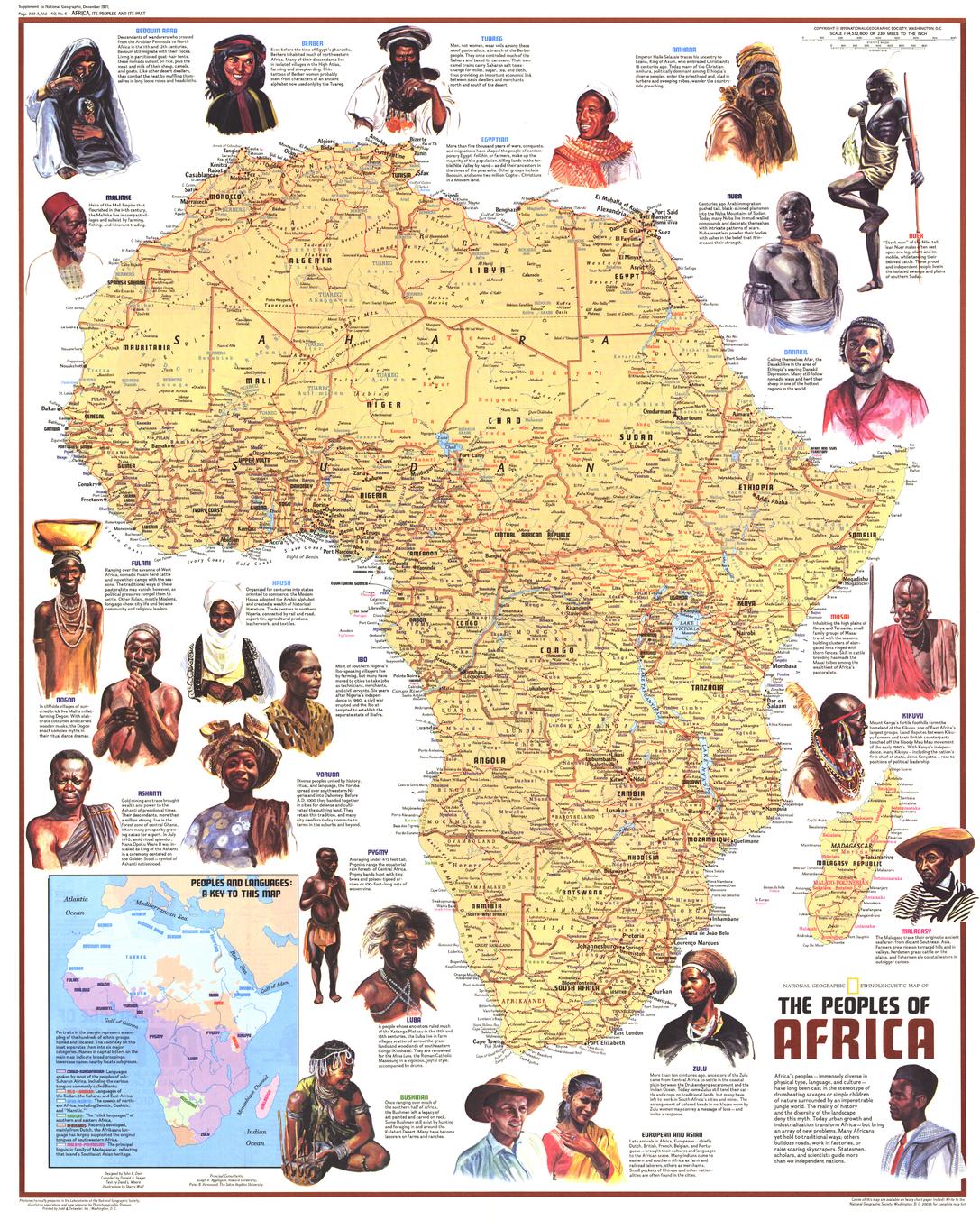
A richly detailed portrait of human diversity across a vast continent, Peoples of Africa maps the intricate tapestry of cultures, languages, and identities that define Africa. Published by National Geographic in December 1971, this map combines cartography, anthropology, and illustration to present a compelling overview of Africa’s peoples.
Issued as part of a two-map set alongside Heritage of Africa, and accompanying the feature article “The Zulus: Black Nation in a Land of Apartheid,” it reflects a moment when global audiences were beginning to engage more deeply with Africa’s cultural complexity.
Why This Map Stands Out
A continent of cultures mapped
Shows ethnic groups identified by name and language.
Anthropological insight
Brings together geography and human diversity in one visual.
Illustrated and informative
Includes artwork and facts that enrich understanding.
Part of a broader narrative
Companion to the Heritage of Africa map.
A distinctive historical piece
Captures perspectives and scholarship of the early 1970s.
🗺️ What the Map Shows
🧑🏾🤝🧑🏿 Ethnic Groups & Languages
- Distribution of major ethnic groups across Africa
- Identification by name and linguistic family
- A visual framework showing how culture and geography intersect
🌍 Cultural Landscapes
- Regional diversity across North, West, East, Central, and Southern Africa
- Patterns of settlement shaped by environment and history
- A continent defined by rich cultural variation rather than uniformity
🎨 Illustrations & Context
- Artistic elements depicting traditional life and identity
- Informative notes adding cultural and historical depth
- A blend of education and visual storytelling
🌐 Understanding Africa’s Diversity
Africa is home to:
- Thousands of distinct ethnic groups
- Hundreds of languages and dialects
- Deep cultural traditions shaped over millennia
- Complex relationships between land, language, and identity
This map captures that diversity—offering a broad yet accessible view of a continent where culture is as varied as the landscape itself.
📐 Size & Format
716 mm (H) × 575 mm (W)
Portrait orientation
A well-balanced format ideal for:
- Classrooms and cultural studies
- Universities and research environments
- Offices and educational spaces
- Home libraries and thoughtful interiors
✨ Premium Finishes & Display Options
Every Peoples of Africa (1971) map is produced using archival-grade materials and precision colour management, ensuring clarity in text, illustration, and thematic detail.
📜 Heavyweight Paper (160 gsm Matte)
Classic. Refined. Frame-ready.
- Premium matte-coated archival paper
- Smooth, low-glare surface for readability
- Ideal for framing under glass
💡 Best for: educational settings and traditional display.
🧼 Laminated (True Encapsulation — 2 × 80 Micron Gloss)
Durable. Practical. Built to last.
- Fully sealed, edge-to-edge protection
- Resistant to handling, moisture, and wear
- Wipe-clean surface for annotation
💡 Best for: classrooms and interactive environments.
🪵 Laminated + Timber Hang Rails
Ready to hang. Clean lines. Contemporary feel.
- Natural timber rails (top & bottom), lacquered finish
- Includes hanging cord
- Keeps map flat without framing
🔨 Please allow up to 10 working days.
💡 Best for: modern, ready-to-hang display.
🖼️ Archival Canvas (395 gsm HP Professional Matte)
Textured. Elegant. Gallery-quality.
- Museum-grade canvas with pigment-based inks
- Subtle texture enhances visual depth
- Non-reflective finish
💡 Best for: feature walls and premium interiors.
🪵 Canvas + Timber Hang Rails
Gallery-ready. Warm. Architectural.
- Canvas paired with timber rails
- Clean, balanced presentation
🔨 Please allow up to 10 working days.
💡 Best for: statement display spaces.
📊 Specifications
| Feature | Detail |
|---|---|
| Title | Peoples of Africa |
| Publisher | National Geographic |
| Published | 1971 |
| Scale | 1:14,572,800 |
| Dimensions | 716 mm × 575 mm |
| Orientation | Portrait |
| Map Type | Thematic |
| Coverage | Africa |
| Collections | Africa, Thematic |
| Materials | 160 gsm matte paper · 2 × 80-micron laminate · 395 gsm HP Professional Matte Canvas |
| Inks | Pigment-based, fade-resistant |
| Origin | Printed in Australia |
🎯 Ideal For
- Students and educators of geography, anthropology, and cultural studies
- Researchers exploring ethnic and linguistic diversity
- Collectors of National Geographic thematic maps
- Interiors seeking a meaningful, educational display piece
- Gift buyers looking for a map with cultural depth
🌍 A Continent of Many Voices
This map reminds us:
- Africa is not one story—but many
- Culture, language, and identity are deeply connected to place
- Diversity is the defining feature of the continent
It’s a map that encourages understanding—offering a clear and compelling view of Africa’s human landscape.
🤝 Our Commitment
- Printed in Australia using archival-quality materials
- Faithfully reproduced to preserve detail and colour
- Premium finishes designed for long-term display
- Each map is hand-checked and carefully packed
🚚 Delivery
- Rolled (Paper, Laminated, Canvas): Dispatch within 1–2 business days
- Hang-Railed Finishes: Made to order — allow up to 10 working days
Explore the diversity of a continent—
a map that brings Africa’s cultures and peoples into clear focus.
Original: $50.05
-65%$50.05
$17.52Product Information
Product Information
Shipping & Returns
Shipping & Returns
Description
Ethnic Groups, Languages & Cultural Landscapes | Thematic Wall Map | 716 × 575 mm | Premium Finishes
A richly detailed portrait of human diversity across a vast continent, Peoples of Africa maps the intricate tapestry of cultures, languages, and identities that define Africa. Published by National Geographic in December 1971, this map combines cartography, anthropology, and illustration to present a compelling overview of Africa’s peoples.
Issued as part of a two-map set alongside Heritage of Africa, and accompanying the feature article “The Zulus: Black Nation in a Land of Apartheid,” it reflects a moment when global audiences were beginning to engage more deeply with Africa’s cultural complexity.
Why This Map Stands Out
A continent of cultures mapped
Shows ethnic groups identified by name and language.
Anthropological insight
Brings together geography and human diversity in one visual.
Illustrated and informative
Includes artwork and facts that enrich understanding.
Part of a broader narrative
Companion to the Heritage of Africa map.
A distinctive historical piece
Captures perspectives and scholarship of the early 1970s.
🗺️ What the Map Shows
🧑🏾🤝🧑🏿 Ethnic Groups & Languages
- Distribution of major ethnic groups across Africa
- Identification by name and linguistic family
- A visual framework showing how culture and geography intersect
🌍 Cultural Landscapes
- Regional diversity across North, West, East, Central, and Southern Africa
- Patterns of settlement shaped by environment and history
- A continent defined by rich cultural variation rather than uniformity
🎨 Illustrations & Context
- Artistic elements depicting traditional life and identity
- Informative notes adding cultural and historical depth
- A blend of education and visual storytelling
🌐 Understanding Africa’s Diversity
Africa is home to:
- Thousands of distinct ethnic groups
- Hundreds of languages and dialects
- Deep cultural traditions shaped over millennia
- Complex relationships between land, language, and identity
This map captures that diversity—offering a broad yet accessible view of a continent where culture is as varied as the landscape itself.
📐 Size & Format
716 mm (H) × 575 mm (W)
Portrait orientation
A well-balanced format ideal for:
- Classrooms and cultural studies
- Universities and research environments
- Offices and educational spaces
- Home libraries and thoughtful interiors
✨ Premium Finishes & Display Options
Every Peoples of Africa (1971) map is produced using archival-grade materials and precision colour management, ensuring clarity in text, illustration, and thematic detail.
📜 Heavyweight Paper (160 gsm Matte)
Classic. Refined. Frame-ready.
- Premium matte-coated archival paper
- Smooth, low-glare surface for readability
- Ideal for framing under glass
💡 Best for: educational settings and traditional display.
🧼 Laminated (True Encapsulation — 2 × 80 Micron Gloss)
Durable. Practical. Built to last.
- Fully sealed, edge-to-edge protection
- Resistant to handling, moisture, and wear
- Wipe-clean surface for annotation
💡 Best for: classrooms and interactive environments.
🪵 Laminated + Timber Hang Rails
Ready to hang. Clean lines. Contemporary feel.
- Natural timber rails (top & bottom), lacquered finish
- Includes hanging cord
- Keeps map flat without framing
🔨 Please allow up to 10 working days.
💡 Best for: modern, ready-to-hang display.
🖼️ Archival Canvas (395 gsm HP Professional Matte)
Textured. Elegant. Gallery-quality.
- Museum-grade canvas with pigment-based inks
- Subtle texture enhances visual depth
- Non-reflective finish
💡 Best for: feature walls and premium interiors.
🪵 Canvas + Timber Hang Rails
Gallery-ready. Warm. Architectural.
- Canvas paired with timber rails
- Clean, balanced presentation
🔨 Please allow up to 10 working days.
💡 Best for: statement display spaces.
📊 Specifications
| Feature | Detail |
|---|---|
| Title | Peoples of Africa |
| Publisher | National Geographic |
| Published | 1971 |
| Scale | 1:14,572,800 |
| Dimensions | 716 mm × 575 mm |
| Orientation | Portrait |
| Map Type | Thematic |
| Coverage | Africa |
| Collections | Africa, Thematic |
| Materials | 160 gsm matte paper · 2 × 80-micron laminate · 395 gsm HP Professional Matte Canvas |
| Inks | Pigment-based, fade-resistant |
| Origin | Printed in Australia |
🎯 Ideal For
- Students and educators of geography, anthropology, and cultural studies
- Researchers exploring ethnic and linguistic diversity
- Collectors of National Geographic thematic maps
- Interiors seeking a meaningful, educational display piece
- Gift buyers looking for a map with cultural depth
🌍 A Continent of Many Voices
This map reminds us:
- Africa is not one story—but many
- Culture, language, and identity are deeply connected to place
- Diversity is the defining feature of the continent
It’s a map that encourages understanding—offering a clear and compelling view of Africa’s human landscape.
🤝 Our Commitment
- Printed in Australia using archival-quality materials
- Faithfully reproduced to preserve detail and colour
- Premium finishes designed for long-term display
- Each map is hand-checked and carefully packed
🚚 Delivery
- Rolled (Paper, Laminated, Canvas): Dispatch within 1–2 business days
- Hang-Railed Finishes: Made to order — allow up to 10 working days
Explore the diversity of a continent—
a map that brings Africa’s cultures and peoples into clear focus.


