Peoples of South Asia - Published 1984 by National Geographic
Ethnic Groups, Religions & Cultural Landscapes | Thematic Wall Map | 720 × 575 mm | Premium Finishes
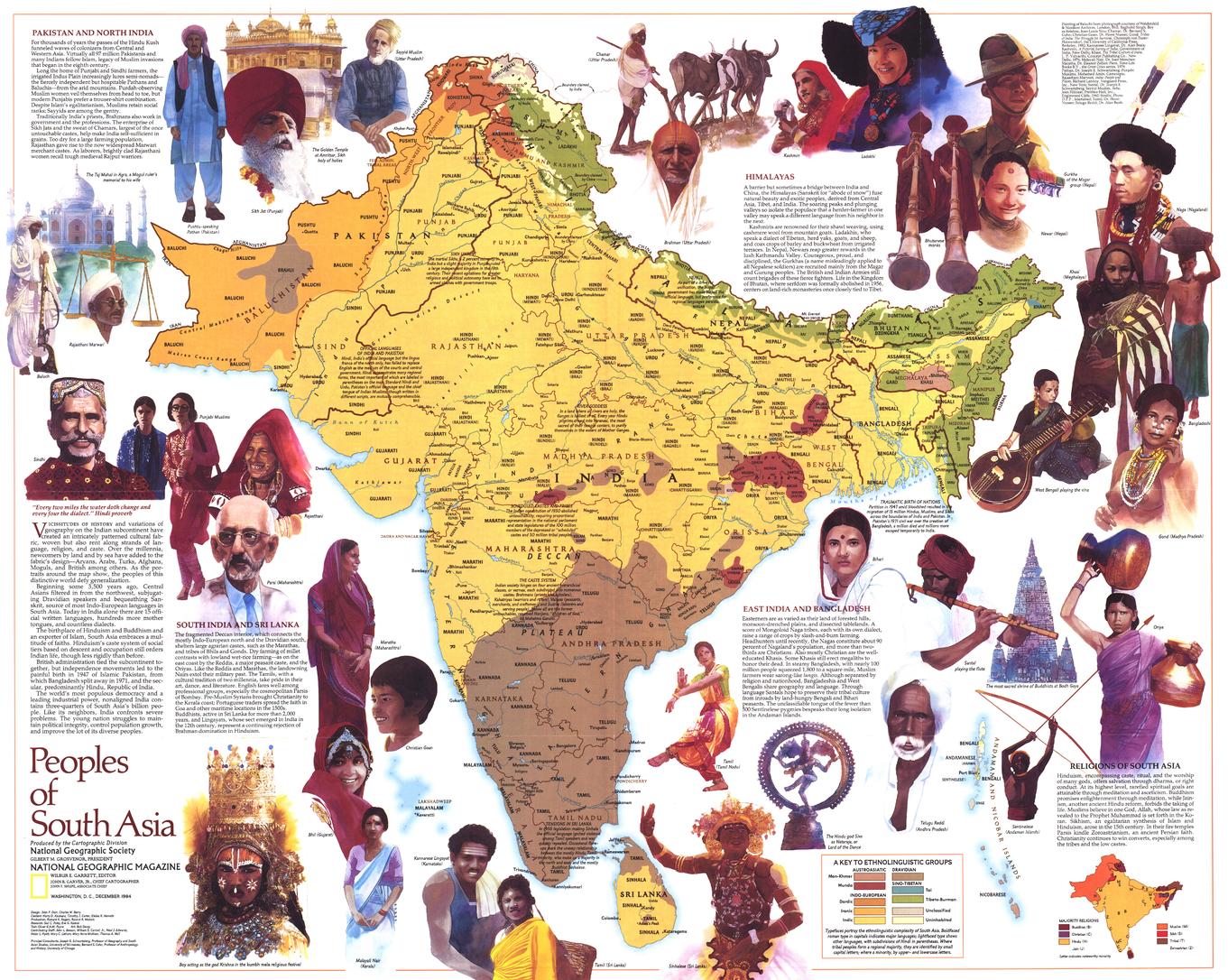
A vivid exploration of one of the world’s most culturally rich regions, Peoples of South Asia reveals the diversity of traditions, languages, and beliefs across South Asia. Published by National Geographic in December 1984, this map blends cartography, anthropology, and illustration to present a layered understanding of the region’s human geography.
Issued as a companion to the South Asia with Afghanistan and Burma map and an article on monsoon systems, it connects people, place, and climate in a compelling visual narrative.
Why This Map Stands Out
A map of cultural depth
Explores ethnic groups, religions, and languages across South Asia.
Richly illustrated
Includes visual elements that bring traditions and daily life into focus.
Context beyond geography
Adds notes on history, belief systems, and ways of life.
Part of a broader regional story
Complements mapping of South Asia’s physical and climatic systems.
A refined educational piece
Balances clarity, detail, and visual appeal.
🗺️ What the Map Shows
🧑🤝🧑 Peoples & Languages
- Distribution of ethnic groups across the region
- Major language families and cultural groupings
- A framework showing how identity is shaped by geography
🕉️ Religions & Traditions
- Key religious landscapes including:
- Hinduism
- Islam
- Buddhism
- Sikhism
- Cultural regions defined by belief systems and heritage
🌏 Regional Coverage
- South Asia, including areas within:
- India
- Pakistan
- Bangladesh
- Nepal
- Sri Lanka
- Afghanistan
- Myanmar (Burma)
- Landscapes shaped by rivers, plains, and mountain systems
🎨 Illustrations & Cultural Insight
- Artwork reflecting traditional life and regional identity
- Informative notes on history, customs, and daily living
- A blend of education and visual storytelling
🌦️ People, Place & Monsoon
South Asia is shaped by powerful forces:
- Seasonal monsoons influencing agriculture and settlement
- River systems supporting dense populations
- Trade routes connecting cultures over centuries
- Deep historical layers shaping modern identity
This map captures those connections—showing how climate, geography, and culture intertwine.
📐 Size & Format
720 mm (W) × 575 mm (H)
Landscape orientation
A versatile size ideal for:
- Classrooms and cultural studies
- Universities and research environments
- Offices and educational spaces
- Home libraries and thoughtful interiors
✨ Premium Finishes & Display Options
Every Peoples of South Asia (1984) map is produced using archival-grade materials and precision colour management, ensuring clarity across text, illustration, and thematic detail.
📜 Heavyweight Paper (160 gsm Matte)
Classic. Refined. Frame-ready.
- Premium 160 gsm matte-coated archival paper
- Smooth, low-glare surface for readability
- Ideal for framing under glass
💡 Best for: educational settings and traditional display.
🧼 Laminated (True Encapsulation — 2 × 80 Micron Gloss)
Durable. Practical. Built to last.
- Fully sealed with 2 × 80-micron laminate
- Edge-to-edge protection against wear and moisture
- Wipe-clean surface for annotation
💡 Best for: classrooms and interactive environments.
🪵 Laminated + Timber Hang Rails
Ready to hang. Clean lines. Contemporary feel.
- Natural timber rails (top & bottom), lacquered finish
- Includes hanging cord for immediate display
- Keeps map flat without framing
🔨 Please allow up to 10 working days.
💡 Best for: modern, ready-to-hang display.
🖼️ Archival Canvas (395 gsm HP Professional Matte)
Textured. Elegant. Gallery-quality.
- Printed on 395 gsm HP Professional Matte Canvas
- Pigment-based inks for long-term colour stability
- Subtle texture enhances visual depth
💡 Best for: feature walls and premium interiors.
🪵 Canvas + Timber Hang Rails
Gallery-ready. Warm. Architectural.
- Canvas paired with natural timber rails
- Clean, balanced presentation
🔨 Please allow up to 10 working days.
💡 Best for: statement display spaces.
📊 Specifications
| Feature | Detail |
|---|---|
| Title | Peoples of South Asia |
| Publisher | National Geographic |
| Published | 1984 |
| Dimensions | 720 mm × 575 mm |
| Orientation | Landscape |
| Map Type | Thematic |
| Coverage | South Asia |
| Collections | Asia, Historical, Thematic |
| Materials | 160 gsm matte paper · 2 × 80-micron laminate · 395 gsm HP Professional Matte Canvas |
| Inks | Pigment-based, fade-resistant |
| Origin | Printed in Australia |
🎯 Ideal For
- Students and educators of geography, religion, and cultural studies
- Researchers exploring ethnic and linguistic diversity
- Collectors of National Geographic thematic maps
- Interiors seeking a meaningful, educational display piece
- Gift buyers looking for a map with cultural depth
🌍 A Region of Layers and Life
South Asia is:
- A meeting place of cultures and civilisations
- A region shaped by climate, especially the monsoon
- Home to deep traditions and diverse identities
- A landscape where history and modern life coexist
This map brings those elements together—offering a clear and compelling view of the peoples who define South Asia.
🤝 Our Commitment
- Printed in Australia using archival-quality materials
- Faithfully reproduced to preserve clarity and colour
- Premium finishes designed for long-term display
- Each map is hand-checked and carefully packed
🚚 Delivery
- Rolled (Paper, Laminated, Canvas): Dispatch within 1–2 business days
- Hang-Railed Finishes: Made to order — allow up to 10 working days
Explore the cultures of a vast region—
a map that brings the peoples of South Asia into clear, human focus.
Original: $50.05
-65%$50.05
$17.52Product Information
Product Information
Shipping & Returns
Shipping & Returns
Description
Ethnic Groups, Religions & Cultural Landscapes | Thematic Wall Map | 720 × 575 mm | Premium Finishes
A vivid exploration of one of the world’s most culturally rich regions, Peoples of South Asia reveals the diversity of traditions, languages, and beliefs across South Asia. Published by National Geographic in December 1984, this map blends cartography, anthropology, and illustration to present a layered understanding of the region’s human geography.
Issued as a companion to the South Asia with Afghanistan and Burma map and an article on monsoon systems, it connects people, place, and climate in a compelling visual narrative.
Why This Map Stands Out
A map of cultural depth
Explores ethnic groups, religions, and languages across South Asia.
Richly illustrated
Includes visual elements that bring traditions and daily life into focus.
Context beyond geography
Adds notes on history, belief systems, and ways of life.
Part of a broader regional story
Complements mapping of South Asia’s physical and climatic systems.
A refined educational piece
Balances clarity, detail, and visual appeal.
🗺️ What the Map Shows
🧑🤝🧑 Peoples & Languages
- Distribution of ethnic groups across the region
- Major language families and cultural groupings
- A framework showing how identity is shaped by geography
🕉️ Religions & Traditions
- Key religious landscapes including:
- Hinduism
- Islam
- Buddhism
- Sikhism
- Cultural regions defined by belief systems and heritage
🌏 Regional Coverage
- South Asia, including areas within:
- India
- Pakistan
- Bangladesh
- Nepal
- Sri Lanka
- Afghanistan
- Myanmar (Burma)
- Landscapes shaped by rivers, plains, and mountain systems
🎨 Illustrations & Cultural Insight
- Artwork reflecting traditional life and regional identity
- Informative notes on history, customs, and daily living
- A blend of education and visual storytelling
🌦️ People, Place & Monsoon
South Asia is shaped by powerful forces:
- Seasonal monsoons influencing agriculture and settlement
- River systems supporting dense populations
- Trade routes connecting cultures over centuries
- Deep historical layers shaping modern identity
This map captures those connections—showing how climate, geography, and culture intertwine.
📐 Size & Format
720 mm (W) × 575 mm (H)
Landscape orientation
A versatile size ideal for:
- Classrooms and cultural studies
- Universities and research environments
- Offices and educational spaces
- Home libraries and thoughtful interiors
✨ Premium Finishes & Display Options
Every Peoples of South Asia (1984) map is produced using archival-grade materials and precision colour management, ensuring clarity across text, illustration, and thematic detail.
📜 Heavyweight Paper (160 gsm Matte)
Classic. Refined. Frame-ready.
- Premium 160 gsm matte-coated archival paper
- Smooth, low-glare surface for readability
- Ideal for framing under glass
💡 Best for: educational settings and traditional display.
🧼 Laminated (True Encapsulation — 2 × 80 Micron Gloss)
Durable. Practical. Built to last.
- Fully sealed with 2 × 80-micron laminate
- Edge-to-edge protection against wear and moisture
- Wipe-clean surface for annotation
💡 Best for: classrooms and interactive environments.
🪵 Laminated + Timber Hang Rails
Ready to hang. Clean lines. Contemporary feel.
- Natural timber rails (top & bottom), lacquered finish
- Includes hanging cord for immediate display
- Keeps map flat without framing
🔨 Please allow up to 10 working days.
💡 Best for: modern, ready-to-hang display.
🖼️ Archival Canvas (395 gsm HP Professional Matte)
Textured. Elegant. Gallery-quality.
- Printed on 395 gsm HP Professional Matte Canvas
- Pigment-based inks for long-term colour stability
- Subtle texture enhances visual depth
💡 Best for: feature walls and premium interiors.
🪵 Canvas + Timber Hang Rails
Gallery-ready. Warm. Architectural.
- Canvas paired with natural timber rails
- Clean, balanced presentation
🔨 Please allow up to 10 working days.
💡 Best for: statement display spaces.
📊 Specifications
| Feature | Detail |
|---|---|
| Title | Peoples of South Asia |
| Publisher | National Geographic |
| Published | 1984 |
| Dimensions | 720 mm × 575 mm |
| Orientation | Landscape |
| Map Type | Thematic |
| Coverage | South Asia |
| Collections | Asia, Historical, Thematic |
| Materials | 160 gsm matte paper · 2 × 80-micron laminate · 395 gsm HP Professional Matte Canvas |
| Inks | Pigment-based, fade-resistant |
| Origin | Printed in Australia |
🎯 Ideal For
- Students and educators of geography, religion, and cultural studies
- Researchers exploring ethnic and linguistic diversity
- Collectors of National Geographic thematic maps
- Interiors seeking a meaningful, educational display piece
- Gift buyers looking for a map with cultural depth
🌍 A Region of Layers and Life
South Asia is:
- A meeting place of cultures and civilisations
- A region shaped by climate, especially the monsoon
- Home to deep traditions and diverse identities
- A landscape where history and modern life coexist
This map brings those elements together—offering a clear and compelling view of the peoples who define South Asia.
🤝 Our Commitment
- Printed in Australia using archival-quality materials
- Faithfully reproduced to preserve clarity and colour
- Premium finishes designed for long-term display
- Each map is hand-checked and carefully packed
🚚 Delivery
- Rolled (Paper, Laminated, Canvas): Dispatch within 1–2 business days
- Hang-Railed Finishes: Made to order — allow up to 10 working days
Explore the cultures of a vast region—
a map that brings the peoples of South Asia into clear, human focus.


